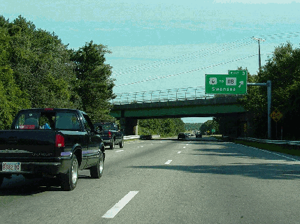
This 2003 photo shows the eastbound Interstate 195 at EXIT 3 (US 6 / GAR Highway) in Swansea. (Photo by Jim K. Georges.)
FROM PROVIDENCE TO CAPE COD: In 1947, the Massachusetts Department of Public Works (MassDPW) announced plans for a "Relocated US 6" that was to handle traffic from the Providence area to Cape Cod. In addition to handling recreational traffic, the proposed route was to revitalize the cities of Fall River and New Bedford, two historic seaports that had fallen on hard times in the postwar era. The expressway was also included as part of a national network devised by the Federal Bureau of Public Roads (BPR).
The first organized effort to construct what would become I-195 came in 1953, when an "Interstate Study Committee" comprised of officials from Massachusetts, Rhode Island, Connecticut and New York announced plans for a 260-mile-long "Cape Cod Expressway." Officials from the MassDPW stated specifically the need for the expressway as follows:
A definite need for a new facility in Massachusetts between Rhode Island and the Cape Cod area is apparent Throughout its entire length, the proposed road would pass through undeveloped areas of potential residential and industrial development, and would be a feeder to the adjacent beach areas without local disturbance.
The necessity for constructing the proposed highway on new location is apparent from the description of the existing US 6. It is a long, winding route of poor alignment and many narrow bridges, and has a great deal of ribbon development throughout its entire length Long and costly delays have occurred as a result of serious traffic congestion in the municipalities along the present US 6, particularly in the cities of Fall River and New Bedford. No control of access is provided, and the intersection of major and minor streets at grade with US 6 has resulted in a serious accident rate throughout the entire route.
Through the commonwealth of Massachusetts, the route of the mainline "Cape Cod Expressway" was to comprise of parts of MA 24 (Fall River Expressway south of I-195), I-195 (east of MA 24), MA 25 and US 6 (Mid-Cape Highway). A "Providence Connection" spur was to extend along the route of the current I-195 west of the Taunton River toward Providence. The $75 million expressway was to be financed by tolls.
In 1956, the MassDPW and the BPR approved parts of the "Cape Cod Expressway" and the "Providence Connection" for inclusion in the Interstate, making them eligible for 90 percent Federal funding, and obviating the need for tolls. The route received a preliminary designation of I-95E, a spur off the mainline I-95.
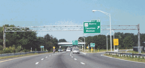
This 2000 photo shows the westbound I-195 at EXIT 8B (MA 24 / Fall River Expressway northbound) in Fall River. The exit for southbound MA 24 is approximately one mile ahead; I-195 and MA 24 overlap along this section. (Photo by Steve Anderson.)
DESIGN AND CONSTRUCTION: Soon after construction began in 1958, the I-95E designation was replaced with I-195. The I-195 designation originally applied only to 25.8 miles of the route from the Massachusetts-Rhode Island border to New Bedford; the remainder of the route was still designated "Relocated US 6." It was not until 1968 when the I-195 designation applied to the then-proposed section east of New Bedford.
Construction progressed on I-195 as follows:
Massachusetts-Rhode Island border in Seekonk to EXIT 3 (US 6 and MA 118) in Swansea: The earliest section of I-195 to open in Massachusetts, this 7.8-mile-long section was constructed between 1958 and 1960, and was completed at a cost of $6 million. According to the Massachusetts Highway Department (MHD), this six-lane section carries approximately 60,000 vehicles per day (AADT).
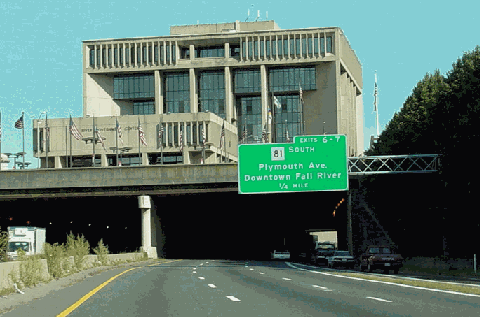
EXIT 3 (US 6 and MA 118) in Seekonk to EXIT 10 (MA 88) in Westport: This six-to-eight lane, 7.1-mile-long section through the city of Fall River was constructed between 1960 and 1965, and was completed at a cost of $40 million. It included the construction of the Charles Braga Bridge, a three-span through-truss bridge over the Taunton River (rebuilt in 1989), and the construction of a new City Hall atop an I-195 tunnel in downtown Fall River, one of the earliest uses of air rights in Massachusetts. For approximately 0.8 mile between EXIT 8A and EXIT 8B, I-195 is multiplexed with MA 24. According to the MHD, this section carries approximately 75,000 vehicles per day.
EXIT 10 (MA 88) in Westport to EXIT 15 (MA 18) in New Bedford: This six-lane, 10.9-mile-long section was constructed between 1963 and 1966, and was completed at a cost of $31 million. According to the MHD, this section carries approximately 55,000 vehicles per day (AADT).
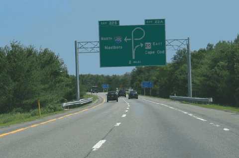
EXIT 15 (MA 18) in New Bedford to EXIT 22 (I-495 / Outer Circumferential Highway and MA 25 Expressway) in Wareham: Narrowing down to four lanes leaving New Bedford, this 14.3-mile-long section, which was not part of the original I-195, was constructed between 1968 and 1974. This section of I-195, which ends at a trumpet interchange, was originally signed "US 6" as shorter sections opened in the early 1970's; it was not until the entire length opened that this section was signed "I-195." According to the MHD, this section carries approximately 30,000 vehicles per day.
When I-195 was first extended into Massachusetts, it continued the sequential exit numbering scheme that began at I-95 in Providence. (However, at that time, exits had not yet been numbered on I-195 in Rhode Island.) Once the expressway was completed in 1974, the sequential exit numbering scheme was reset at the Massachusetts-Rhode Island border.
This 2003 photo shows the eastbound I-195 tunnel beneath Fall River City Hall. The tunnel was completed in 1965. The new city hall, whose predecessor was demolished in 1962 to make way for I-195, was delayed until the mid-1970's. (Photo by Jim K. Georges.)
A NEW CITY HALL FOR FALL RIVER, RIGHT ON TOP OF I-195: To make way for I-195, the old Fall River City Hall was demolished in 1962. Mayor John Arruda persuaded officials to propose a new idea: building a new city hall above I-195. It was to be the first use of air rights above a Massachusetts highway. Although the I-195 tunnel through Fall River was opened to traffic in 1965, the land above the highway remained vacant for several years thereafter.
The city hall proposal did not get far under either Arruda or his successor, Nicholas Mitchell, who added a parking garage to the original plan. It took a third mayor, Wilfred Driscoll, who succeeded Mitchell in 1972, to get construction underway for the new city hall. However, the parking garage was left out of the final proposal.
The design approved by Driscoll resembled a "bridge" that was to reunite neighborhoods divided by construction of I-195 during the 1960's. Problems plagued construction of the six-story building, including distorted beams, cracked concrete and broken windows. The $9 million city hall finally opened in 1976.
CURRENT AND FUTURE IMPROVEMENTS: The MHD and the Southeastern Regional Planning and Economic Development District (SRPEDD) have proposed the following projects along I-195:
In two separate projects, the MHD resurfaced four miles of I-195 in the Seekonk-Swansea area, and another four-mile section in the New Bedford-Fairhaven area. The $11 million combined project, which was completed in late 2002, included the resurfacing of several bridges.
At EXIT 3 (US 6 and MA 118) in Swansea, the SRPEDD recommended a reconstruction of the interchange to include a new westbound off-ramp at MA 118, and a widening of the US 6 overpass at I-195. The interchange, which is chronically congested due to its proximity to the Swansea Mall, has been suggested for inclusion in the MHD Transportation Improvement Program after 2005.
In Fall River, the MHD resurfaced I-195 through the city and rehabilitated the tunnel underneath City Hall. The $13 million project was completed in 2004.
At EXIT 12 (Faunce Corner Road) in Dartmouth, the SRPEDD recommended the construction of new ramps at the existing partial cloverleaf interchange. It recommends the widening of the Faunce Corner Road overpass to four lanes, the signalization of the ramp that serves the eastbound I-195 turning movement to northbound Faunce Corner Road, and the construction of a loop ramp in the northeast quadrant. Geometric improvements were also recommended for the terminus of each existing ramp consistent with current design standards. In 1999, the MHD purchased right-of-way for these improvements. The $18 million reconstruction of EXIT 12, which was originally scheduled for 2005, began in 2008.
To address safety concerns at EXIT 15 (MA 18 / John F. Kennedy Memorial Highway in New Bedford--specifically the traffic conflicts caused by the two loop ramps in close proximity on westbound I-195, the MHD and the SRPEDD developed plans to close the existing loop ramp from northbound MA 18 to westbound I-195. In a two-year study completed in 2002, the report cited 36 crashes within a 400-foot section of westbound I-195 between the two ramps.One proposal has traffic turning right from MA 18 onto Coggeshall Street in the city's north end and then onto the existing slip ramp from Coggeshall Street onto westbound I-195, about one-half mile east of the existing loop ramp. This would be carried out in conjunction with a widened Coggeshall Street. Another proposal features the creation of a new signalized left-turn from northbound MA 18 onto an extended Cedar Grove Street, which would serve as a service road for I-195 and from which a new slip ramp for westbound I-195 would be built.
Finally, the MHD began a $1 million study in 2005 to study possible improvements to EXIT 22 (I-495 and MA 25) in Wareham.
This 2006 photo shows the eastbound I-195 about two miles from its terminus at EXIT 22 (MA 25 Expressway and I-495) in Wareham. (Photo by Steve Anderson.)
The I-195 designation should be extended east along the MA 25 Expressway and the Mid-Cape Highway (US 6) to Orleans. The designation also should apply to a currently unbuilt connection along the Cape Cod Canal between the two expressways.
SOURCES: "New England Road Project Backed," The New York Times (10/29/1953); "New England South Shore Highway," Interstate Study Committee (1953); "Traffic and Highway Study for East Providence, Barrington, Warren and Bristol, Rhode Island," Wilbur Smith and Associates (1955); "A Report of Progress," Massachusetts Department of Public Works (1962); "The Massachusetts Highway Story (1949-1969)," Massachusetts Department of Public Works (1969); "Southeastern Massachusetts Comprehensive Transportation Plan," Massachusetts Department of Public Works (1969); "Proposed Route 25 and Route 28: Final Environmental Impact and Section 4(f) Statement," Federal Highway Administration and Massachusetts Department of Public Works (1978); "City Hall Plan Controversial Right from the Beginning" by Shalise M. Manze, The Providence Journal (9/26/1999); "Bridge Rehab Due" by Mac Daniel, The Boston Globe (2/17/2002); Regional Transportation Plan, Southeastern Massachusetts Metropolitan Planning Organization (2007); Massachusetts Highway Department; Southeastern Regional Planning and Economic Development District; Jay Hogan; Chris O'Leary; Dan Moraseski; Paul Schlichtman; Alexander Svirsky.
I-195 shield by Ralph Herman. Lightposts by Millerbernd Manufacturing Company.