
|
|
||
|
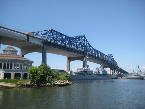
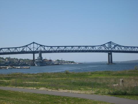
This 2014 photo shows the Charles Braga Bridge (I-195) looking west from Fall River Heritage State Park. The World War II battleship USS Massachusetts (BB-59) shown here in this photo has made Fall River its home since 1965, the year the Braga Bridge was completed. The bridge was repainted blue from its original green in 2013. (Photo by Steve Anderson.) |
||
|
Type of bridge: |
||
|
Cantilver and truss |
||
|
WHERE THE TAUNTON RIVER MEETS NARRAGANSETT BAY: Early planning for what was then known as the "Somerset-Fall River Bridge" began in the 1950s when it was part of a Providence spur to the proposed Cape Cod Expressway, a 260-mile-long toll road connecting New York City with Cape Cod. The securing of Interstate funding for what was initially designated I-95E - which was re-designated I-195 in 1959 - brought the hope of relieving congestion on the nearby Brightman Street Bridge (US 6) closer to reality. |
||
|
It was necessary for engineers to design a high-level bridge to carry I-195 across the busy Taunton River, where many tall vessels served industrial areas and power plants along the Fall River and Somerset sides of the river. Although the Brightman Street Bridge was a double-leaf bascule drawbridge that provided adequate vertical clearance, the old span, which was completed in 1908, had only 98 feet of horizontal clearance. |
||
|
The main bridge over the navigation channel close to the Fall River shoreline is a three-span continuous cantilever-truss (Warren truss) design. The main span measures 840 feet from pier-to-pier and is flanked by two side spans measuring 382 feet in length. At its highest point above the Taunton River, the bridge provides 135 feet of vertical clearance. There are 24 continuous plate-girder approach spans of varying width from 145 feet to 200 feet. |
||
|
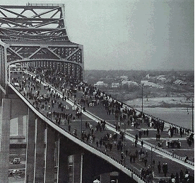
The $22 million Braga Bridge was opened to traffic in 1966. At 5,780 feet from abutment to abutment, the span was the third longest in New England after the Tobin Bridge in Boston and the Jamestown Bridge in Rhode Island; the opening of the Newport (Pell) Bridge in 1969 pushed the Braga Bridge into fourth place. |
||
|
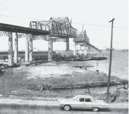
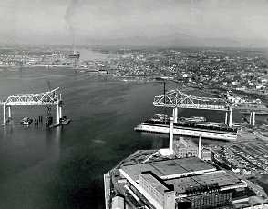
TOP PHOTOS: These two photos from 1964 show the Braga Bridge (I-195) under construction over the Taunton River. |
||
|
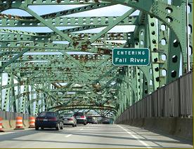
This 2007 photo shows the eastbound Braga Bridge (I-195) approaching Fall River in its original green paint scheme. (Photo by Alex Nitzman, www.aaroads.com.) |
||
|
MAINTAINING THE BRAGA BRIDGE: As the Braga Bridge approached a quarter-century of service in 1989, the MassDPW undertook a comprehensive two-year rehabilitation of the span and approaches. The project included the replacement of the existing deck with a new lightweight deck overlaid with bituminous concrete. Construction crews repaired and repainted structural steel along the length of the mile-long span, a new concrete ("Jersey") barrier was built in the center median, and "suicide fences" were built along the length of the span. |
||
|
In 2003, the Massachusetts Highway Department (MHD) began a three-year, $9 million rehabilitation of the Braga Bridge. The scope of the work was similar to that of the 1989-1990 project, but the new top concrete layer of roadway was given a latex additive that resists water seepage and thus reduces cracking. Originally scheduled for completion in 2005, the end of the project was re-scheduled for 2006 because of delays associated with the nearby Government Center project along I-195 in Fall River. |
||
|
This 2014 photo shows the Charles Braga Bridge (I-195) looking south from the Fall River shoreline. (Photo by Steve Anderson.) |
||

|
SOURCES: "New England Road Project Backed," The New York Times (10/29/1953); "New England South Shore Highway," Interstate Study Committee (1953); "Traffic and Highway Study for East Providence, Barrington, Warren and Bristol, Rhode Island," Wilbur Smith and Associates (1955); "US Steel Low Bid on Superstructure for State Bridge, The Boston Globe (8/10/1961); "A Report of Progress," Massachusetts Department of Public Works (1962); "Big Mamie Getting Spruced Up," The Boston Globe (7/04/1965); "The Massachusetts Highway Story (1949-1969)," Massachusetts Department of Public Works (1969); "Bridge Rehab Due" by Mac Daniel, The Boston Globe (2/17/2002); "Braga Bridge Project Update" by Daniel Barbarisi, The Providence Journal (5/09/2003); "Bridge Work Stalls Commuters" by Bridget Botelho, Providence Business News (4/20/2004); "No Relief for I-195 Commuters" by Steve Urbon, The Standard-Times (6/06/2004); "Future Foggy for Braga" by Gregg M. Miliote, The Herald-News (7/07/2005); "Walk Across the Braga Bridge 50 Year Ago a Day To Remember" by Caitlin Westgate, The Herald-News (4/10/2016); "Sweet Relief: Braga Work Will Be Completed in 2017" by Michael Holtzman, The Herald-News (4/14/2016); Massachusetts Highway Department; Alexander Svirsky. |
||

|
CHARLES BRAGA BRIDGE LINKS: |
||
|
CHARLES BRAGA BRIDGE CURRENT TRAFFIC CONDITIONS: |
||
|
CHARLES BRAGA BRIDGE VIDEO LINKS: |
||

|
|
||

|
Back to The Crossings of Metro Boston home page. |
||
|
Site contents © by Eastern Roads. This is not an official site run by a government agency. Recommendations provided on this site are strictly those of the author and contributors, not of any government or corporate entity. |
||