 |
|
|
|
|
|
|
|
|
|
|
|
|
|
|
|
|
|
|
|
|
|
|
|
|
|
|
|
|
|
|
|
|
|
|
|
|
|
|
|
|
|
|
|
|
|
|
|
|
|
|
|
|
|
|
|
|
|
|
|
|
|
|
|
|
|
|
|
|
|
|
|
|
 |
|
|
|
|
 |
|
 |
|
|
|
|
|
|
|
|
|
|
|
|
|
|
|
|
 |
|
|
|
|
|
|
|
 |
|
|
|
|
|
|
|
|
|
|
|
|
|
|
|
|
|
|
|
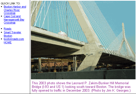
The Leonard P. Zakim-Bunker Hill Memorial Bridge -- Boston's signature span -- takes its place with the city's skyline serving as its backdrop in this 2002 photo. (Photo by Alexander Svirsky.)
|
|
|
|
|
|
|
|
|
 |
|
|
|
|
 |
|
|
|
|
|
|
|
|
Type of bridge
Construction started
Opened to traffic
Length of main span
Length of side spans
Total length of bridge and approaches
Width of bridge
Number of traffic lanes
Height of towers above mean high water
Clearance at center above mean high water
Cost of original structure
|
|
|
|
|
|
|
|
|
Cable-stay
October 1, 1997
March 30, 2003 (northbound)
December 20, 2003 (southbound)
745 feet (227.1 meters)
295 feet (89.9 meters)
1,457 feet (444.1 meters)
183 feet (55.8 meters)
10 lanes
322 feet (north tower)
295 feet (south tower)
40 feet (12.2 meters)
$105,000,000
|
|
|
|
|
|
|
|
|
|
|
|
|
|
|
|
|
|
|
 |
|
|
|
|
|
THE FIRST CHARLES RIVER BRIDGE: Plans for a Charles River Bridge between Boston and Charlestown - the most distant ancestor of the Zakim Bridge - date back to 1720. It took John Hancock and a group of private investors what others had not been able to do in 66 years: build a bridge across the Charles. The 1,503-foot-long wooden bridge opened in 1786. It was supported by 75 piers, and the 42-foot-wide roadway provided a 30-foot-wide carriageway for horse traffic and two pedestrian walkways.
|
|
|
|
|
|
|
|
|
|
|
|
|
|
A BRIDGE FOR THE ELEVATED CENTRAL ARTERY: The commonwealth's 1948 master transportation plan for Boston called for the construction of a new highway bridge between Boston and Charlestown. It was to be built as part of the long-delayed "Central Artery," an elevated highway through downtown Boston that had been in various planning stages since 1930.
The dual-deck Warren steel truss bridge still standing across the Charles River is known officially as the "High Bridge." Now limited to carrying southbound I-93 and US 1 traffic, the High Bridge was built in 1952, but it did not open to traffic until the initial section of the Central Artery was completed two years later.
Originally designed to handle 50,000 vehicles per day (AADT), the bridge had carried more than 200,000 vehicles per day a half-century later. The upper level carried three lanes of northbound traffic, while the lower level carried three lanes of southbound traffic. Less than a quarter-mile separated the Storrow Drive (MA 3) ramps to the south from the Tobin Bridge (US 1) ramps to the north, and poor ramp geometry and a lack of acceleration-deceleration led to hundreds of weaving accidents during the past 50 years.
HIGH BRIDGE IS FALLING DOWN� As the High Bridge neared the end of its design life, the signs of age and deterioration accelerated. Horizontal steel beams grafted to the elevated approaches connected to the rusting main span in almost ad-hoc fashion, and many of the joints showed signs of advanced fatigue.
On May 28, 1999, motorists bound for northern New England for the Memorial Day weekend that Friday afternoon experienced tire blowouts. The Massachusetts State Police shut down the bridge, and inspectors discovered that the upper deck of the High Bridge separated from the roadway by eight inches. The cause: three of the four rusted stringer beams supporting the upper deck had failed.
The High Bridge did not stand for much longer. After traffic was diverted from the old span to the new Zakim Bridge during 2002 and 2003, the old High Bridge was demolished in early 2004.
|
|
|
|
|
|
|
|
|
|
|
|
|
|
 |
|
|
|
|
|
 |
|
|
|
|
|
|
|
|
This 2001 photo shows the northbound I-93 over the old High Bridge. The Leonard P. Zakim-Bunker Hill Memorial Bridge under construction on the left. (Photo by Jim K. Georges.)
|
|
|
|
|
|
|
|
|
|
|
|
|
|
|
|
|
|
|
|
FROM A TO "SCHEME Z": As plans were being developed for putting I-93 underground during 1988 for the "Central Artery / Tunnel Project," attention turned to a new crossing of the Charles River. With state Transportation Secretary Fred Salvucci leading the effort, engineers devised 31 different schemes for crossing the Charles including a wide tunnel, a box girder span, an arch span, a suspension span and a cable-stay span.
|
|
|
|
|
|
|
|
|
|
|
|
|
|
The inability to come to a consensus infuriated the Reagan Administration, over whose veto Congress approved the multi-billion dollar "Big Dig" in 1987. Republican officials leaned on the Democratic State House to get the mega-project underway immediately, or risk losing funding.
With the entire Big Dig threatened, Salvucci felt compelled to make a snap decision on the Charles River Crossing. He offered "Scheme Z," an all-bridge design that featured 18 travel lanes on six levels. While it was the most environmentally friendly to the Charles River, it was so aesthetically unfriendly that it received poor marks from not only the U.S. Environmental Protection Agency (EPA), but also Salvucci's own design team.
|
|
|
|
|
|
|
|
|
|
|
|
|
|
By 1991, with William Weld pushing Michael Dukakis out of the State House, Salvucci no longer held his post as Transportation Secretary. This meant that the Charles River Crossing once again was up for grabs. During the next two years, a 42-member design committee met with community, business and environmental groups to decide upon a new design. The result was an $800 million bridge-and-tunnel design called "8.1.d Mod 5."
Even this latest design did not pass muster with James Kerasiotes, the new Transportation Secretary under Governor Weld. Kerasiotes had his own team of engineers review designs. By 1994, after six years of hearings and false starts, planners finally arrived at a design for the Charles River Crossing. The design received final state and Federal environmental approval in June of that year.
|
|
|
|
|
|
|
|
|
|
|
|
|
|
|
|
|
|
|
|
|
|
|
THE "BABY BRIDGE": Just west of the cable-stay bridge is a four-lane bridge connecting I-93 in Somerville with Storrow Drive and Leverett Circle in Boston. Such a connector had been planned as early as the 1950s, but opposed by wealthy Bostonians who feared that the connector would feed too much traffic into Beacon Hill and Back Bay. By the time the connector was finally approved in 1994, such resistance had waned.
|
|
|
|
|
|
|
|
|
|
|
|
|
|
The steel box-girder span was approved in April 1997 as the low-bid contender for the Storrow Drive Connector, and work on the bridge began soon thereafter. During the summer of 1998, nine large "tub" girders measuring from 9 to 18 feet deep - in cross-section the largest in North America - were shipped by barge from Tampa to Boston, and carefully maneuvered along the Charles River locks. The nine girders, which together form a trapezoid, were raised into place by cranes and jacks onto concrete piers.
The 830-foot-long Storrow Drive Connector opened to traffic on October 7, 1999, several weeks ahead of schedule. It boasts a 380-foot-long main span and 225-foot-long back span, and its 76-foot-width carries four lanes of traffic between I-93 and Storrow Drive. In 2001, the connector won the "prize bridge" award in the medium-long span category from the National Steel Bridge Alliance (NSBA).
CONSTRUCTION PROGRESS ON THE MAIN SPAN: The erection of the two main towers began in the waning days of 1998. During early 1999, work began on the approaches to the bridge. Construction of new ramps to the southern approach was complicated by the presence of the existing elevated ramps connecting the old Central Artery with Leverett Circle. Eventually, the old ramps were closed and demolished.
With the towers completed by late 1999, workers began to construct the main roadway and connecting cables. Engineers cut 70 small diamond- and hexagonal-shaped holes into the bridge's deck to allow light to reach the river below. By the summer of 2001, with the project nearing completion, engineers discovered a flaw: workers were forced to tear up a large section of the bridge deck when it was discovered that the concrete had not adhered properly to the steel rebar inside.
THE BRIDGE OPENS: The bridge was near completion on May 12, 2002, when it opened to the public (that is, to pedestrians) for the first time. It was formally dedicated on October 6, 2002 to the memory of Leonard P. Zakim, the executive director of the New England office of the Anti-Defamation League of B'nai B'rith who died in 1999. The bridge also honors the memory of those who fought in the nearby Battle of Bunker Hill in 1775. (However, local traffic reporters prefer the moniker "Zakim Bridge" rather than the longer formal name.) A second bridge walk and a concert by Bruce Springsteen, a favorite performer of Zakim's, marked the formal dedication.
On March 30, 2003, the Zakim Bridge opened to northbound I-93 traffic for the first time. The opening coincided with the completion of the new northbound Central Artery ("Liberty") Tunnel. The southbound lanes of the bridge and the southbound tunnel opened to traffic on December 20, 2003.
On November 1, 2009, the newly formed Massachusetts Department of Transportation (MassDOT) assumed jurisdiction over the bridge and its approaches from the former Massachusetts Turnpike Authority, which ceased to exist effective on that date.
BLENDING INTO THE COMMUNITY: To mitigate the impact of the new span, officials decided to use subtle blue and white lighting to illuminate the towers and cables. The lighting scheme is intended to accentuate, but not drown out the Boston skyline.
After the High Bridge was demolished in 2004, workers began construction of a $96 million park that contains 40 acres of parkland, seven miles of pedestrian and bicycle paths, and marinas. The park, also called "contract 29F" and part of the Rose Kennedy Greenway that opened in 2008, was built mostly on right-of-way from the old High Bridge.
|
|
|
|
|
|
|
|
|
|
|
|
|
|
|
 |
|
|
|
|
|
|
|
|
This 2003 photo shows the Storrow Drive Connector, looking south toward downtown Boston The connector was opened to traffic in 1999, four years before the Zakim Bridge. (Photo by Jim K. Georges.)
|
|
|
|
|
|
|
|
|
|
|
|
|
|
|
|
|
|
|
 |
|
|
|
 |
|
|
|
|
|
SOURCES: "Central Artery (I-93) and Third Harbor Tunnel (I-90), Boston, Massachusetts: Final Supplemental Environmental Impact Statement," Federal Highway Administration, Massachusetts Department of Public Works and Massachusetts Turnpike Authority (1991); Rescuing Prometheus by Thomas P. Hughes, Pantheon Books (1998); The Big Dig by Dan McNichol, Silver Lining Books (2001); "Bridging the Big Dig" by John Nordell, The Christian Science Monitor (3/22/2001); "Flaws Exposed on Zakim Bridge" by Thomas C. Palmer, Jr., The Boston Globe (7/28/2001); "Out of the Tunnel, Into the Light" by Elizabeth Wray, Bechtel Briefs (August 2001); "A Walk into the Future" by Raphael Lewis, The Boston Globe (5/09/2002); "Span Links Vision, Reality" by Doug Hanchett, The Boston Globe (10/06/2002); "New I-93 Tunnel Has Curves and Learning Curves" by Mac Daniel, The Boston Globe (4/06/2003); "Other Green Monster Falls: Central Artery Demolition To Be Complete Within a Year" by Anthony Flint, The Boston Globe (10/28/2003); "End of the Road: Artery Closes, Tunnel Opens" by Dave Wedge, The Boston Herald (12/20/2003); Massachusetts Turnpike Authority; Alexander Svirsky.
I-93 and US 1 shields by Ralph Herman.
Lightposts by Millerbernd Manufacturing Company.
|
|
|
|
|
|
|
|
|
|
|
|
|
|
|
|
 |
|
 |
|
|
|
|
|
|
|
|
|
|
|
|
|
|
|
|
|
|
|
|
|
 |
|
|
|
|
|
|
|
|
|
 |
|
|
|
|
|
|
|
|
 |
|
|
|
|
|
|
|
|
|
|
|
|
Site contents © by Eastern Roads. This is not an official site run by a government agency. Recommendations provided on this site are strictly those of the author and contributors, not of any government or corporate entity.
|
|
|
|
|
|
|
|
|
|