This 2003 photo shows the northbound Northeast Expressway (US 1) approaching the Western Avenue exit in Chelsea. From the late 1950s through the early 1970s, this section of the Northeast Expressway was designated I-95 in anticipation of its completion north to the MA 128 / I-95 interchange in Peabody. (Photo by Jim K. Georges.)
OVER THE MYSTIC RIVER TO THE NORTH SHORE: In 1948, officials from the Massachusetts Department of Public Works (MassDPW) proposed an expressway to connect downtown Boston and the Central Artery with the North Shore area. The plan included a new dual-deck, six-lane bridge connecting Charlestown with Chelsea.
The MassDPW cited its case for the Northeast Expressway as follows:
Traffic flow in the northeast section is divided between a route through Everett and the North Shore route through Chelsea, Revere and Lynn. This traffic is presently served by Rutherford via Sullivan Square, Broadway in Everett, Chelsea Street through Charlestown, Broadway through Chelsea and Revere, and US 1 (Newburyport Turnpike) and MA 1A to points north and northeast.
In considering the need for an expressway to the northeast, it was found that one expressway between these two routes could serve this entire area. This location coincides with that now being developed for the new six-lane, high-level Mystic River (Tobin) Bridge between Charlestown and Chelsea. At the present time, a considerable amount of traffic that would otherwise use this proposed route travels via MA 1A and the Sumner Tunnel due to the congestion encountered in passing through Charlestown and Chelsea via the Mystic River Bridge. When the new Northeast Expressway is completed, a large portion of this traffic would be diverted from the Sumner Tunnel because of the more direct route provided. Therefore, the new Northeast Expressway will furnish needed relief for the Sumner Tunnel.
DESIGN AND CONSTRUCTION: Under the original 1948 plan, the six-lane Northeast Expressway was to follow its current alignment through Revere to US 1 (then designated C-1), an existing four-lane divided highway. A four-lane expressway spur was to be constructed from just south of MA 60 (Squires Road) east to MA 1A (North Shore Road) in Revere Beach. The mainline Northeast Expressway was expected to carry approximately 40,000 vehicles per day (AADT), while the Revere Beach Spur was expected to carry approximately 10,000 vehicles per day.
Interchanges were to be constructed at the following locations:
Central Artery (I-93), Charlestown
City Square, Charlestown Everett Avenue, Chelsea Fifth Street, Chelsea Revere Beach Parkway (MA 16), Revere Park Avenue, Revere (later moved to Sargent Avenue, Revere) Squire Road (MA 60) / Cutler Circle, Revere Broadway (MA 107), Revere North Shore Road (MA 1A), Revere
Excluding the Tobin Bridge, the Northeast Expressway and the Revere Beach Spur - totaling 4.9 miles in length - were estimated to cost $15 million.
Construction of the Tobin Memorial Bridge and its approaches began in 1948, and two years later, the span was opened to traffic. Immediately thereafter, work began on constructing the connections to the south. While the ramps to the dual-deck "High Bridge" of the Central Artery were completed in 1953, they did not open to traffic until the first section of the Central Artery opened in 1955.
North of the Mystic River, work began on extending the Northeast Expressway in 1953. From 1953 to 1956, the MassDPW constructed a six-lane elevated expressway through Chelsea, and from 1956 to 1958, extended the expressway (as a combination of embankment and depressed sections) into Revere. By 1958, the length of the expressway from Charlestown to Revere (as it exists today) had opened to traffic.
YESTERDAY AND TODAY
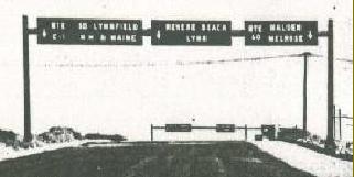
TOP: This 1958 photo shows the unfinished northbound Northeast Expressway approaching its terminus at MA 60 in Revere. The sign for "Revere Beach / Lynn" was covered when the expressway opened; it was to lead to the unbuilt section of expressway north of Revere. (Photo by Massachusetts Department of Public Works; supplied by Dan Moraseski.)
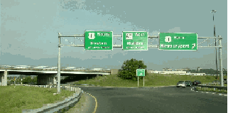
BOTTOM: This 2000 photo shows the Cutler Circle (US 1-MA 60) interchange in Revere. (Photo by Jim K. Georges.)
ONCE AN INTERSTATE: While the Federal Bureau of Public Roads (BPR) included the Northeast Expressway as part of the preliminary Interstate highway network in 1955, the expressway, which received the I-95 designation by the end of the 1950's, does not meet contemporary Interstate standards. Like most expressways of the pre-Interstate era, the Northeast Expressway has limited sight distances, sharp curves, inadequate shoulders, and substandard acceleration-deceleration lanes.
In 1973, the I-95 designation on the Northeast Expressway was removed following the cancellation of I-95 within MA 128 (Yankee Division Highway). The US 1 designation first appeared on the expressway in 1976.
In the early 1980s, the MassDPW rebuilt the elevated section through Chelsea. During the $12 million project, construction crew removed the entire pavement (which had been plagued with potholes over the years), leaving only the steel support beams and girders, and installed a new six-lane roadway.
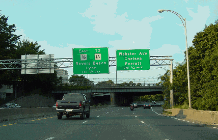
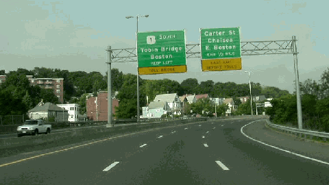
This 2000 photo shows the southbound Northeast Expressway (US 1) at the Carter Street exit in Chelsea. (Photo by Jim K. Georges.)
"LOWERING CANA" THROUGH CHARLESTOWN: Beginning in 1977, the MassDPW began to study ways to improve the interchange between US 1 and I-93, just north of the Charles River. The study evolved into the "Central Artery North Area project," and the MassDPW released final plans in 1981 as follows:
The existing "Y"-interchange between US 1 and I-93 was to be replaced with a double-decked, high-speed loop between I-93 and US 1 (to accommodate northbound-to-northbound and southbound-to-southbound traffic). The existing setup had created a serious merge weave problem on I-93 over the High Bridge (Charles River): traffic from Storrow Drive had to negotiate three lanes of I-93 traffic in order to reach the approach for the Tobin Bridge (US 1). The new loop ramp was to be constructed over the Boston and Maine (MBTA) railroad yard, and the double-deck design of the loop was to match the existing I-93 design. The Northeast Expressway (US 1) was to be tunneled (using a pair of three-lane tunnels) beneath City Square in Charlestown. Once the tunnel was completed, the elevated highway was to be torn down, freeing up 12 acres for parkland and other development, and reconnecting Chelsea Street in the process.
The project was originally estimated to cost $140 million and take four years, but spiraling costs and complications in obtaining right-of-way hiked the estimates to $230 million and seven years.
Work on the project finally got underway in 1987. The Massachusetts Highway Department (MHD) constructed a 710-foot-long, seven-span structure looping from the I-93 roadway to the US 1 approach to the Tobin Memorial Bridge. Temporary piers supported the structure prior to the completion of the Leonard P. Zakim-Bunker Hill Bridge in 2002. The MHD also constructed a pair of three-lane tunnels beneath City Square, and created City Square Park on the site of the former elevated highway. The "Central Artery North Area project" was completed in September 1994.
According to the Massachusetts Department of Transportation (MassDOT), the successor to the MHD, the Northeast Expressway carries approximately 75,000 vehicles per day (AADT).
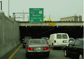
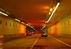
These 2002 photos show the Northeast Expressway (US 1) through the City Square Tunnel in Charlestown (left photo is the southbound portal, right photo is the northbound tunnel). The tunnel was completed in 1994 as part of the "Central Artery-North Area" project. (Photos by Jim K. Georges.)
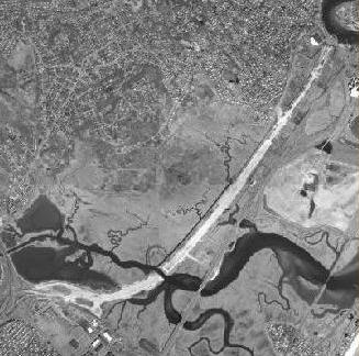
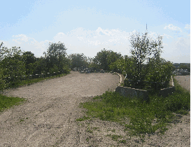
This aerial photo shows the graded embankment of what was to be the Northeast Expressway (I-95) extending north of the MA 60 (Cutler Circle) interchange and the Pines River into Saugus. (Photo by John D. Evans, Massachusetts Institute of Technology.)
AN UPGRADE TO EXISTING ROUTE 1: The 1948 Master Highway Plan for the Boston Metropolitan Area advocated that the existing US 1 (Newburyport Turnpike) be upgraded to freeway standards from the northern terminus of the Northeast Expressway in Revere to beyond the then-proposed MA 128 (Yankee Division Highway) in Peabody. Specifically, the report made the following recommendation:
An examination of existing US 1 from the new expressway to MA 128 indicates that while this highway is adequate insofar as lane capacity is concerned, further improvements are necessary if it is to continue as a safe, efficient artery for the large volumes of high-speed traffic using this interstate route. Studies of various locations and comparisons of cost estimates have led to the conclusion that in this instance, it would be more economical and expeditious to improve the existing highway to interstate standards as a limited-access facility than to construct a new, modern highway in a new location requiring the taking of expensive rights-of-way. This can be accomplished by acquiring the necessary property on one side of the existing highway sufficient in width to provide for service roads and other features necessary in the development of a limited-access facility.
The expressway was to utilize the following interchanges at existing locations:
Broadway (MA 99), Saugus
Essex Street, Saugus Main Street, Saugus Walnut Street (MA 129), North Saugus Salem Street (MA 129), South Lynnfield
The report estimated that it would cost $5.3 million to improve the 6.6 miles of US 1 to six-lane, controlled-access standards, complete with service roads and grade separations.
EXTENDING THROUGH SAUGUS, LYNN AND PEABODY: When state and Federal officials approved I-95 through Boston in the late 1950's, they selected a new route through Saugus, Lynn and Peabody. Extending north of MA 128 (Yankee Division Highway), I-95 was to be routed parallel to the existing US 1 to the newly opened "US 1 Relocation" (which was re-designated I-95) in Danvers.
The six-lane Northeast Expressway was to be widened to eight lanes in Saugus, where the route was to intersect a proposed extension of the East Boston Expressway (MA 1A). To minimize right-of-way acquisition costs, the expressway was to be routed through the Lynn Woods Reservation.
Construction of the section of I-95 in Revere and Saugus began in 1967 with the placement of large quantities of fill in the Saugus Marsh. However, this ended up being the only work completed along the route.
REVISING THE ROUTE OF I-95: In 1968, two decades after it released the Master Highway Plan, the MassDPW updated its highway plans in the Recommended Highway and Transit Plan. To alleviate congestion along substandard sections of the existing Northeast Expressway and the Central Artery - both of which had been designated I-95 at the time - the report advocated the construction of a new "Third Harbor Tunnel" and "Shore Expressway" (to be constructed roughly along MA 1A) to handle I-95 traffic.
From the Recommended Highway and Transit Plan:
The existing I-95 from Cutler Circle to the Chelsea approach to the Tobin Bridge was built before the start of the Interstate highway program, and is substandard according to Interstate design standards. Raising this section of roadway to Interstate standards, however, would be virtually impossible on the present alignment and would elevate the cost of improvement to an unjustified amount. Less costly improvements, such as the addition of acceleration-deceleration lanes to meet higher standards, better gradients on some approach ramps, and partial reconstruction of the Revere Beach Parkway (MA 60) interchange, would substantially increase the safety of this roadway.
I-95 in Charlestown between the Tobin Bridge and the Storrow Drive exit ramps from the Central Artery is presently a source of frustration to peak-period motorists. Severe congestion also occurs in the Sumner and Callahan tunnels, as commuters frequently face long lines of stopped traffic stretching the length of the tunnel. It is clear that major harbor crossing improvements are needed to handle today's traffic satisfactorily, let alone the increases projected to occur by 1990.
From Saugus north to Danvers, the late 1950's proposal to construct an eight-lane I-95 remained intact. According to the 1968 master plan, this section of the Northeast Expressway was estimated to carry approximately 145,000 vehicles per day (AADT) by 1990. The plan also estimated that it would cost $79 million to construct the 13.4 miles of I-95 on new right-of-way from Revere north to Danvers, and $22 million to upgrade the existing Northeast Expressway through Revere and Chelsea.
CONTROVERSY THROUGH LYNN WOODS: In 1970, Governor Francis Sargent ordered a moratorium on all new expressway construction within MA 128 (Yankee Division Highway), and ordered a review of expressway and transit plans in the Boston area. The Boston Transportation Planning Review (BTPR) was birthed from the governor's action. Through the North Shore, the particular issue was the controversial alignment of I-95 through the Lynn Woods Reservation, the Walden Reservoir and the wetlands along the Saugus River.
The conclusion of the BTPR Phase I report (dated December 29, 1971) made the following recommendation for the I-95 alignment north of Revere:
Either a four-lane expressway, or a six-lane expressway in which two lanes are reserved for buses and other special purpose vehicles, is being considered. Both the originally proposed alignment for I-95 through Lynn and Peabody, and the newly developed (existing) US 1 alignment, remain in consideration at this time. Priority attention will be given to the US 1 alignment to determine whether it is a feasible and prudent alternative, while work proceeds on an improved design through Lynn Woods. Sub-options of US 1 alternative include rebuilding within the existing right-of-way, as well as constructing a new parallel facility.
During BTPR Phase II studies in June 1972, Governor Sargent announced the elimination of the originally proposed route of the I-95 (Northeast Expressway) section through Saugus Marsh and the Lynn Woods Reservation, citing that no "feasible and prudent" alternative route could be constructed through the area. The final BTPR study also recommended an $18 million "non-Interstate arterial" upgrade to the existing US 1 from Revere north to Danvers. Subsequently, in 1973, I-95 was routed along the existing MA 128 (Yankee Division Highway). The end of the Northeast Expressway story came on May 23, 1974, when Federal funds from the unbuilt I-95 and I-695 were officially transferred to the Massachusetts Bay Transportation Authority (MBTA).
Today, vestiges such as unused bridges, closed exit ramps and graded embankments reveal long-abandoned attempts to extend I-95 north of Cutler Circle in Revere.
ABORTED ATTEMPT TO UPGRADE US 1: Soon after the "Lynn Woods" segment of I-95 was canceled, the MassDPW proposed a freeway upgrade of the existing US 1 from Cutler Circle in Revere north to MA 128 (Yankee Division Highway) in Lynnfield. US 1 was to be converted into a 2-2-2-2 configuration along the existing grade: the inner lanes were to be controlled-access, and the outer lanes were to be service roads for the businesses that line the route. The proposal was abandoned quickly amid business protests of right-of-way acquisition.
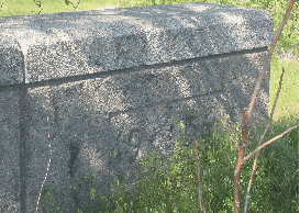
These 2005 photos show the some of the unused roadways, bridges, and graded areas that were to carry the Northeast Expressway (I-95) north of Revere. Note the 1956 construction date on the bridge parapet. (Photos by Steve Anderson.)
SOURCES: Master Highway Plan for the Boston Metropolitan Area, Massachusetts Department of Public Works (1948); "A Report of Progress," Massachusetts Department of Public Works (1962); "Inner Belt and Expressway System," Massachusetts Department of Public Works (1962); Recommended Highway and Transit Plan, Massachusetts Department of Public Works (1968); "The Massachusetts Highway Story (1949-1969)," Massachusetts Department of Public Works (1969); "Drive in Boston May Bring a New Urban Transit Mix" by Bill Kovach, The New York Times (7/24/1970); "Mass Transit Plan for Massachusetts" by Bill Kovach, The New York Times (11/30/1972); Boston Transportation Planning Review: Final Study Summary Report, Massachusetts Department of Public Works (1972); "Route 1 Corridor Rebuild," Massachusetts Department of Public Works (1972); "I-93 / US 1 Interchange, Draft Environmental Impact and Section 4(f) Statement," Federal Highway Administration and Massachusetts Department of Public Works (1977); "A Highway Without Potholes? Yes, But Only Because Pavement's Gone, Too," The Boston Globe (4/18/1981); "Central Artery North Area Project, Final Environmental Impact and Section 4(f) Statement," Federal Highway Administration and Massachusetts Department of Public Works (1981); "I-93 Meets US 1: Checkered Past Led to Chaotic Present" by Peter J. Howe, The Boston Globe (11/26/1987); "Salem-Beverly Transportation Project," Massachusetts Department of Public Works (1990); "City Square Vent Sets Wright Tone" by Robert Campbell, The Boston Globe (7/30/1993); "More Ramps Off Tobin Open," The Boston Globe (9/08/1994); "New Ramps Are a Turn-Off" by Tom Palmer, The Boston Globe (11/02/1994); Massachusetts Highway Department; Dan Moraseski; Ron Newman; Scott Oglesby; Fred Salvucci; George Sanborn; Paul Schlichtman; Matt Smith; Jack Suslak; Alexander Svirsky; Yanni Tsipis.
US 1 and I-95 shields by Ralph Herman. Lightposts by Millerbernd Manufacturing Company.


