Bookmark and Share

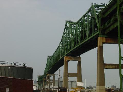
This 2002 photo shows the main cantilever span of the Maurice J. Tobin Bridge (US 1) from the Mystic River waterfront in Chelsea. (Photo by Jim K. Georges.)

Type of bridge:
Construction started:
Opened to traffic:
Length of main cantilever span
("Big Mystic"):
Length of side cantilever spans
("Big Mystic"):
Length of main truss span
("Llittle Mystic"):
Total length of bridge and approaches:
Width of bridge:
Width of roadways:
Number of decks:
Number of traffic lanes:
Height of towers above mean high water:
Clearance at center above mean high water
("Big Mystic"):
Clearance at center above mean high water
("Little Mystic"):
Cost of original structure:

Cantilever and truss
April 12, 1948
February 27, 1950

800 feet (243.8 meters)

362 feet, 6 inches (110.5 meters)

439 feet (133.8 meters)
11,906 feet (3,628.9 meters)
42 feet (12.8 meters)
36 feet (11.0 meters)
2 decks
6 lanes (3 upper, 3 lower)
254 feet (77.4 meters)

135 feet (41.1 meters)

100 feet (30.5 meters)
$27,000,000

Passenger car pay-by-plate toll (both directions):
Passenger car EZ-Pass toll (both directions):

$1.55
$1.25
(Commuter discounts available)

REQUIEM FOR THE OLD CHELSEA NORTH BRIDGE: Plans for a high-level fixed highway span across the Mystic River between Charlestown and Chelsea date back to 1933, when a state legislative commission recommended its construction. At that time, motorists depended on the Chelsea North Bridge, a two-lane swing span built in 1910 that connected Chelsea Street in Charlestown with Broadway in Chelsea.

With the commonwealth lacking funds during the Great Depression, it decided instead to rehabilitate the existing Chelsea North Bridge. The bridge was closed during much of 1935 while the steel swing span was refurbished and the steel roadway deck (supported by heavy timber trestles) was rebuilt. The bridge reopened the following year, but it did not take long before a major shipping accident shut down the span once again. In May 1936, the freighter Californian rammed into the bridge's draw section and caused significant structural damage.

PART OF A HIGHWAY LINK TO THE NORTH SHORE: The surge in traffic that came with the end of World War II brought a new sense of urgency to local and state officials to build a new fixed span across the Mystic River. The surge in postwar traffic volume from the developing North Shore suburbs, combined with the frequent openings (as many as 7,000 per year) of the Chelsea Street swing span resulted in a traffic nightmare. It was estimated that 54% of the traffic accidents in Chelsea were attributed to congestion leading to the bridge.

In 1946, the Massachusetts State Legislature set up an independent commission to finance and build the Mystic River Bridge. The proposed bridge was incorporated into the state's plans for express highway network serving Boston and its environs, and was to connect the Central Artery with the Northeast Expressway.

The new bridge also was planned to relieve congestion on the two-lane Sumner Tunnel. From the
Master Highway Plan for the Boston Metropolitan Area:

In considering the need for an expressway to the northeast, it was found that one expressway between these two routes could serve this entire area. This location coincides with that now being developed for the new six-lane, high-level Mystic River (Tobin) Bridge between Charlestown and Chelsea. At the present time, a considerable amount of traffic that would otherwise use this proposed route travels via MA 1A and the Sumner Tunnel due to the congestion encountered in passing through Charlestown and Chelsea via the Mystic River Bridge. When the new Northeast Expressway is completed, a large portion of this traffic would be diverted from the Sumner Tunnel because of the more direct route provided. Therefore, the new Northeast Expressway will furnish needed relief for the Sumner Tunnel.

The superstructure was built under the auspices of the Mystic River Bridge Authority (later part of the Massachusetts Port Authority, or Massport), while the expressway approaches were designed under the jurisdiction of the Massachusetts Department of Public Works (MassDPW).

DESIGN AND CONSTURCTION: To accommodate navigable vessels on the Mystic River, engineers designed a cantilever bridge with a main span of 800 feet. The bridge has a minimum clearance of 135 feet above the Mystic River. Concrete piers support from below the steel superstructure of the cantilever bridge. Two large concrete piers, each dug 85 feet beneath sea level, also provide support for the span's 254-foot-tall towers. The maximum height of the truss on the main Mystic River span is 115 feet.

A smaller Warren-truss span was designed to carry traffic over the Little Mystic River. The Warren truss has a main span length of 439 feet, and because the Little Mystic is less heavily trafficked by navigable vessels, the truss has a minimum clearance of only 100 feet above the water. Two concrete piers support each end of the Warren-truss span. The maximum height of the truss on the Little Mystic River span is 65 feet.

The approaches are comprised of 36 plate-girder spans on the Chelsea side of the bridge, and 32 plate-girder spans on the Charlestown side of the bridge. A 12-span plate-girder bridge, on which the southbound toll plaza is located, connects the cantilever (Mystic River) and Warren-truss (Little Mystic River) span. Each of the plate-girder spans has an average length of about 100 feet. Steel piers support each of the viaduct spans.

The bridge was designed with two vehicular traffic decks: the upper deck for southbound traffic, the lower deck for northbound traffic. Each of the traffic decks is 36 feet wide, and both decks are flanked by three-foot-wide emergency walkways. On the 12-span toll plaza, the roadway of the upper deck widens to 102 feet to accommodate seven toll collection lanes. (At the time of the bridge's opening, the 15-cent tolls also were collected on the lower level.) One consideration in favor of building a double-deck bridge was that it required the condemnation of fewer properties.

After two years of construction, the Mystic River Bridge opened to traffic on February 27, 1950. In the years immediately following the opening of the span, connections were constructed to the Central Artery (I-93 and US 1) and the Northeast Expressway (US 1). During its first full year of operation, the bridge carried approximately 13.5 million vehicles. The original plan called for Massport to remove the tolls and hand over jurisdiction of the bridge to the commonwealth once the last of the $27 million in bonds were retired in 1978.

RENAMED TO HONOR GOVERNOR TOBIN: In 1967, the Mystic River Bridge was renamed in honor of Maurice J. Tobin, former Boston mayor and Massachusetts governor. During his one term in office (1945-1946), Tobin created Massport and ordered construction of the Mystic River Bridge. Tobin went on to serve as labor secretary under President Harry Truman before he died in 1953.

LEFT: This 2002 photo shows the cantilever span of the Tobin Bridge from the Charlestown side of the Mystic Bridge. Note the elevated toll plaza on the upper deck of the viaduct. RIGHT: This 2002 photo shows the truss span over the Little Mystic River from the Charlestown side of the bridge. (Photos by Jim K. Georges.)

ONCE PART OF THE INTERSTATE SYSTEM: The Federal Bureau of Public Roads (BPR) included the bridge part of the preliminary Interstate highway network in 1955, and soon received the I-95 designation. In 1973, the I-95 designation on the bridge was removed following the cancellation of "Lynn Woods" section of the Northeast Expressway. The US 1 designation first appeared on the bridge in 1976.

COLLAPSE SHUTS DOWN SPAN: On September 10, 1973, an overloaded truck traveling northbound on the Tobin Bridge rammed into a support beam, knocking the southbound deck on the viaduct section onto the northbound deck and creating a traffic mess. The collapse shut down the bridge for more than two months as worked repaired both decks of the collapsed viaduct section. The bridge finally reopened to traffic on December 1, 1973.

TURNPIKE AUTHORITY SEEKS TO BUY BRIDGE, BUT THEN BALKS: During the mid-1990s, Governor William Weld proposed ambitious legislation to resolve funding troubles on the Central Artery-Tunnel ("Big Dig") project. Under the legislation, the Massachusetts Turnpike Authority would not only take over the "Big Dig" project, but also purchase the Tobin Bridge from the Massport for $74 million. The deal would have given Massport a windfall profit after paying off $48 million in remaining bridge debt, and compensation for the communities of Charlestown and Chelsea to compensate for the impact of the bridge.

However, officials the Turnpike Authority balked at the plan when they determined that the Tobin Bridge, which only had a 50-cent one-way toll at the time, generated $6 million in tolls, but had an annual maintenance and repair costs of $7.5 million. The $1.5 million loss did not include more than $100 million in major rehabilitation and repainting work planned for the bridge.

REHABILITATING THE TOBIN BRIDGE: Since the early 1990s, there has been more than $100 million in major rehabilitation work done on the Tobin Bridge. Some of these projects are as follows:

  • In 1993, Massport completed the rehabilitation of the Tobin Bridge toll plaza. The project included the construction of a wide lane for oversize vehicles, new tollbooths and electronic toll collection machines (to accommodate Fast Lane, and later EZ-Pass), and a new administration building.

  • Shortly thereafter, Massport began a decade-long repainting project. During the nine-stage project, which was completed in 2004, older coats of lead-based paint were removed and an environmentally-friendly paint mixture was applied. To protect residents along the Charlestown and Chelsea approaches, Massport ordered full site containment with mechanical ventilation, recovery of removed paint as hazardous waste, and on-site environmental monitoring.

  • In the late 2000s, Massport undertook a $30 million rehabilitation of the two traffic decks.

The Tobin Bridge carries approximately 85,000 vehicles per day (AADT), and approximately 60% of vehicles use the Fast Lane / EZ-Pass toll collection system. On January 1, 2010, the newly formed Massachusetts Department of Transportation's (MassDOT) highway division took over jurisdiction of the bridge from Massport.

YOU CAN'T MISS THE TOLLS NOW: In 2016, the MassDOT installed new all-electronic tolling (AET) equipment above both the northbound and southbound lanes of the bridge, replacing the toll plaza at mid-span. Prior to the AET installation, tolls were collected only in the southbound direction.

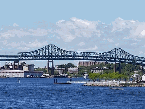
This 2017 photo shows the main cantilever span of the Tobin Bridge (US 1) from Boston Harbor. (Photo by Steve Anderson.)

SOURCES: Master Highway Plan for the Boston Metropolitan Area, Massachusetts Department of Public Works (1948); "Bridge for Boston" by John H. Fenton, The New York Times (2/28/1950); "Why We Don't Fly Out of Hegenberger Airport" by Peter J. Howe, The Boston Globe (4/23/1989); "Weld Offers Highway Solution" by Peter J. Howe, The Boston Globe (1/13/1995); "Mass Turnpike Authority Balks at Buying Bridge" by Laura Brown, The Boston Globe (2/12/1995); "Boston's Maurice J. Tobin Memorial Bridge Gets Rehabilitation for Its 50th Birthday" by John Gartner, Roads and Bridges (March-April 2000); Boston's Bridges by Alexander Svirsky, Arcadia Publishing (2004); "Everybody on the Tobin Bridge Will Soon Have To Pay Tolls" by John R. Ellement, The Boston Globe (6/07/2016); Bay State Design; Massachusetts Department of Transportation; Michael G. Koerner; Dan Moraseski; Alexander Svirsky.

  • US 1 shield by Ralph Herman.
  • Lightposts by Millerbernd Manufacturing Company.

MAURICE J. TOBIN (MYSTIC RIVER) BRIDGE LINKS:

TOBIN BRIDGE CURRENT TRAFFIC CONDITIONS:

TOBIN BRIDGE VIDEO LINKS:

Back to The Crossings of Metro Boston home page.

Site contents © by Eastern Roads. This is not an official site run by a government agency. Recommendations provided on this site are strictly those of the author and contributors, not of any government or corporate entity.