 |
|
|
|
|
|
|
|
|
|
|
|
|
|
|
|
|
|
|
|
|
|
|
|
|
|
|
|
|
|
|
|
|
|
|
|
|
|
|
|
|
|
|
|
|
|
|
|
|
|
|
|
|
|
|
|
|
|
|
|
|
|
|
|
|
|
|
|
|
|
|
|
|
|
|
|
|
|
|
|
|
 |
|
|
|
|
 |
|
 |
|
|
|
|
|
|
|
|
|
|
|
|
|
|
|
|
 |
|
|
|
|
|
|
|
 |
|
|
|
|
|
|
|
|
|
|
|
|
|
|
|
|
|
|
|
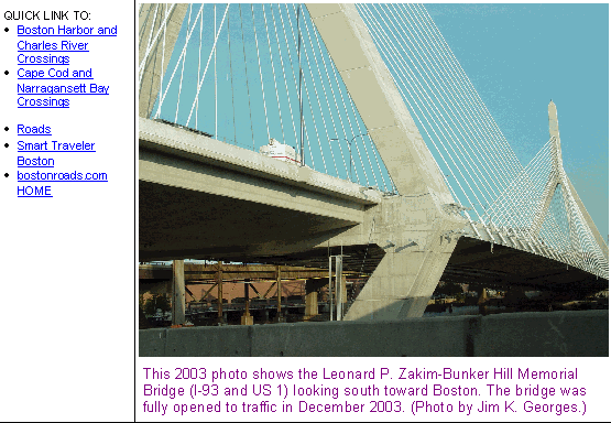
This 2003 portal shows the South Boston portal of the Ted Williams Tunnel (I-90). (Photo by Jim K. Georges.)
|
|
|
|
|
|
|
|
|
 |
|
|
|
|
 |
|
|
|
|
|
|
|
|
Construction started:
Opened to traffic:
Number of tubes:
Number of traffic lanes:
Length between portals:
Operating headroom of tunnel:
External diameter of tunnel:
Maximum depth, mean high water to roadway:
Length of each immersed tunnel section:
Number of immersed tunnel sections:
Total weight of immersed tunnel sections:
Total concrete used in approaches:
Total material dug for tunnel:
Total number of tiles:
Supply and exhaust fans:
Cost of original structure:
|
|
|
|
|
|
|
|
|
December 19, 1991
December 15, 1995
2 tubes
4 lanes
8,500 feet (2,590.8 meters)
13 feet, 6 inches (4.1 meters)
40 feet (12.2 meters)
100 feet (30.5 meters)
325 feet (99.1 meters)
12 sections
396,000 tons (359,245 metric tons)
450,000 cubic yards (344,050 cubic meters)
890,000 cubic yards (680,454 cubic meters)
1,400,000 tiles
34 fans
$1,900,000,000
|
|
|
|
|
|
|
|
|
|
|
|
|
|
|
|
|
|
|
|
|
|
|
Passenger car pay-by-plate toll (both directions):
Passenger car non-MA EZ-Pass toll (both directions):
Passenger car MA EZ-Pass toll (both directions):
|
|
|
|
|
|
|
|
|
$2.05
$1.75
$1.50
(Commuter discounts available)
|
|
|
|
|
|
|
|
|
|
|
|
 |
|
 |
|
|
|
|
|
Hazmat and height restrictions apply.
|
|
|
|
|
|
|
|
|
|
|
|
|
|
|
|
|
 |
|
|
|
|
|
NEARLY 35 YEARS IN PLANNING: When ground broke for the Callahan Tunnel (MA 1A) back in 1957, officials from the Massachusetts Department of Public Works (MassDPW) had forecast the need for a third tunnel underneath Boston Harbor, this time connecting South Boston with East Boston. However, the state did not develop any studies at the time.
|
|
|
|
|
|
|
|
|
|
|
|
|
|
The first specific plans for the tunnel surfaced in 1968, when the state released its Recommended Highway and Transit Plan for the Boston metropolitan area. The "New Harbor Crossing," as it was called in the report, was to connect the Massachusetts Turnpike (I-90) and the John F. Fitzgerald Expressway / Central Artery (then I-95, now I-93) in South Boston with a proposed extension of the East Boston Expressway (MA 1A) in East Boston. The proposed $144 million tunnel also was to provide direct access to Logan International Airport.
The report described the need for a new tunnel as follows:
Traffic using the Tobin Bridge and the Sumner and Callahan tunnel currently amounts to approximately 120,000 vehicles per day. Improvement of the approach facilities and elimination of restrictions caused by toll collection would allow a total flow of about 160,000 vehicles per day (100,000 on the Tobin Bridge, and 60,000 in the Sumner and Callahan tunnels) at the lowest acceptable level of service.
The daily crossings of the Boston Harbor and Mystic River in 1990 will amount to approximately 186,000 vehicles without a New Harbor Crossing, and 203,000 vehicles with a New Harbor Crossing, according to forecasts made by a consultant for the Massachusetts Turnpike Authority. Based on the overload on present facilities by 1990 of 26,000 to 43,000 daily trips, a New Harbor Crossing would be necessary some time after 1975. Unless another harbor crossing is included in the future expressway system, additional capacity will have to be provided on the bridge or the tunnels, and improvements will have to be made to the Central Artery in addition to those already anticipated.
Financial studies by the Massachusetts Turnpike Authority's consultant indicate that anticipated toll revenue from this new crossing, if constructed by the Turnpike Authority, would not be adequate to construct the approaches necessary to ensure efficient operation of the roadway system at both ends of the crossing. The possibility of getting Interstate designation for this New Harbor Crossing should be investigated. If this designation is obtained, the construction of this facility could be advanced to the 1968-1975 program to provide relief to the present harbor crossing facilities and the Central Artery at an earlier date.
|
|
|
|
|
|
|
|
|
|
|
|
|
|
|
|
|
The 1968 plan also called for the tunnel and its approaches to carry the I-95 designation, taking traffic away from the already congested Central Artery (which at the time was I-95). From there, I-95 was to continue to the southwest via the Southwest Expressway, and to the northeast via the East Boston and Northeast expressways. The cancellation of these feeder expressways during the early 1970s meant a return to the drawing board.
During 1971 and 1972, the Boston Transportation Planning Review (BTPR) recommended construction of the "New Harbor Crossing," even as it dashed plans for most new expressway construction inside Route 128. It presented the following alternatives for the tunnel:
|
|
|
|
|
|
|
|
|
|
|
|
 |
|
|
|
|
|
|
|
|
|
|
HERE'S THE SCOOP: On December 19, 1991, Governor William Weld began the "visible" construction of the Central Artery / Tunnel project - the official name of the "Big Dig" - by smashing a champagne bottle into a large piece of construction equipment known as a "Super Scoop." The world's largest dredging vessel, the "Super Scoop," which is owned by the Dutra Group, was used to dig a 50-foot-deep, 100-foot-wide trench for three-quarters of a mile beneath Boston Harbor. Workers dug the trench to accommodate the 12 immersed tube tunnel (ITT) sections that would comprise the main underwater tunnel.
|
|
|
|
|
|
|
|
|
|
|
|
|
|
As work began on digging the trench, engineers encountered the problem of what to do with the dredged material. In addition to rock, clay and soft sediments, the dredged material contained oil, heavy metals and other materials. The Army Corps of Engineers denied a permit of disposal of the material 20 miles offshore, but Massport was willing to take the material as landfill for its airport expansion plans. To mitigate the environmental impact on the immediate area, workers lined the disposal site with two layers of plastic sheeting, applied the site with lime to soak up moisture and prevent runoff, and topped off the site with another laying of plastic sheeting and earthen fill. A total of 890,000 cubic yards of material was moved to dig the trench.
Even the fish were given considerable attention in preparing the trench. Prior to rock blasting in the harbor, a $1 million electronic "noise" device was used to send an ultrasonic pulse that would scare fish away from the blasting zone.
THE TUNNEL ARRIVES, SECTION BY SECTION: Beginning in September 1992, the first of the 12 ITT sections arrived in the Reserve Channel. Each of the twin-tube tunnel sections measures 325 feet long and weighs 7,500 tons. Each tube within the ITT section has a diameter of 40 feet, enough to accommodate two traffic lanes. The ITT sections were prefabricated at the Bethlehem Steel shipyard in Baltimore, and sent by barge at a rate of one a month 400 miles north to the tunnel site at Black Falcon Terminal.
The Black Falcon Terminal resembled one large floating assembly line. When each section arrived, it was placed at the end of the dock where the "assembly line" began. Assembly teams placed 25,000 tons of concrete roadway deck and 33,000 tons of steel reinforcement bars inside each ITT section. The concrete and steel were placed carefully so as not to capsize the ITT section that was being floated. When each section was finished, it was floated out by barge to the trench in Boston Harbor, and the next section was pushed up the "assembly line."
Before the first ITT section was shipped out to the harbor, a cement truck was taken apart on the dock and its contents were placed inside the ITT section. The truck was reassembled once the ITT section was lowered into place.
|
|
|
|
|
|
|
|
|
|
|
|
|
|
 |
|
 |
|
|
|
|
|
|
|
|
LEFT: This 1993 photo shows the beginning of the ITT sections at the East Boston portal. The East Boston land tunnel approach was built to connect to the main underwater tunnel. RIGHT: This 1994 photo shows the construction of the South Boston cofferdam, where the underwater tunnel meets the South Boston land tunnel approach. (Photos by Peter Vanderwalker, from the Big Dig / Ted Williams Tunnel photo gallery at www.masspike.com/bigdig; website no longer active.)
|
|
|
|
|
|
|
|
|
|
|
|
|
|
|
|
|
|
|
|
AT THE BOTTOM OF BOSTON HARBOR, A MIX OF HIGH TECH AND HARD LABOR: Once each section was sent to the trench, it was maneuvered into place by a "laybarge," which resembled one large catamaran, at a depth of up to 100 feet beneath the water's surface. Straddling the ITT section with its pontoons, the laybarge lowered each section into place by cables. To help the laybarge get each ITT section in the proper place, a laser beam was shot underneath the harbor along the centerline of the tunnel's alignment, and a global positioning system (GPS) was used to determine the exact location of each section. All 12 ITT sections had been lowered into the trench by the fall of 1994.
|
|
|
|
|
|
|
|
|
|
|
|
|
|
As each section was lowered, underwater construction divers aligned the ITT sections into their final placement. However, they had to work in less than optimal conditions. Since the water temperature was usually less than 60 degrees Fahrenheit, they had hot water pumped into their suits. They often had less than 12 inches of visibility, so they had lights attached to the exterior of their diving helmets. Many divers kept their eyes closed, instead relying on their sense of touch. They made sure that the connections between the ITT sections were secure and airtight.
Work later began on making the final connections between the ITT sections. Water, sand and rock trapped between the sections were sucked out with pumps, pipes and values until a hydrostatic seal - a pressurized, airtight seal in which air and water pressures are kept at equilibrium - permanently connected each ITT section. Granite boulders were placed around and above each section for protection.
Once this was done, welders, carpenters and cement mixers worked at connecting each tunnel section from the inside. Ironworkers removed the steel bulkhead at the end of each ITT section, while the gaps between each section were filled with concrete and steel. The 12 ITT sections were finally connected by the summer of 1995.
BUILDING THE CONNECTING LAND TUNNELS: Construction of the South Boston and East Boston land tunnels began during the summer of 1992 and took three years to complete. A total of 450,000 cubic yards of concrete were used for these approaches. The land tunnels, which were to connect to the main underwater tunnel, proved difficult to build.
Both approaches were to plow through weak soil that was 100 percent landfill. To stabilize the soil, engineers employed a Japanese technique of soil stabilization that had never been used in the eastern United States. It was a three-step process involving liquefying the soil, mixing the soil with concrete and freezing the soil-concrete mix. The material dug from the land tunnels were sent to Spectacle Island, the site of a former city dump that is being converted into a 100-acre public park.
For the South Boston approach, engineers designed the approach tunnel with a 17-inch-thick roadway surface called a gravity slab, which was tied by cables to the bedrock below, to prevent the tunnel from sinking. They also built a 250-foot-diameter, 85-foot-deep cofferdam - the largest ever built in North America - so that a short connecting tunnel could be built between the main underwater tunnel and the South Boston approach. The cofferdam has 13-foot-thick walls to restrain tidal forces.
Engineers also had to be careful when building the East Boston ("Bird Island Flats") land tunnel approach, which went through Logan Airport property. An additional four feet of concrete were laid atop the tunnel to support a runway above. Connecting underground ramps were built from the tunnel to the airport terminals above. During construction, all vehicles had to pass through security checkpoints, which often slowed progress.
Two ventilation buildings were built atop the land tunnel approaches. The East Boston building has 14 exhaust and ten supply fans, while the South Boston building has six exhaust and four supply fans.
|
|
|
|
|
|
|
|
|
 |
|
|
|
|
|
 |
|
|
|
|
|
|
|
|
This 2003 photo shows the eastbound Ted Williams Tunnel (I-90). A direct exit for Logan Airport -- EXIT 137 (former EXIT 26) on the Massachusetts Turnpike -- is provided in the East Boston land tunnel approach. (Photo by Jim K. Georges.)
|
|
|
|
|
|
|
|
|
|
|
|
|
|
|
|
|
|
|
|
|
|
|
|
|
|
|
|
|
|
"It's taken 30 years to give the people of Massachusetts some relief. This is going to be terrific for the region's economy and quality of life. We've had a resource in Logan airport that been rendered less useful over the years, as a result of congestion. Now the airport is once again just minutes from the core city, and that's an economic treasure." - James J. Kerasiotes, state transportation secretary, upon the completion of the Ted Williams Tunnel (1995)
|
|
|
|
|
|
|
|
|
|
|
|
|
|
A LAST-MINUTE PROBLEM: Prior to the opening of the tunnel, thousands of gallons of saltwater seeped into the South Boston approach, causing tiles to fall off and discoloring the tunnel walls. Workers injected thousands of gallons of grout into the tunnel walls, which stopped the seepage. Several years later, the same problem delayed the opening of the Fort Point Channel tunnel, which connects the Ted Williams Tunnel approach with the Massachusetts Turnpike to the west.
THE TUNNEL OPENS: The Ted Williams Tunnel opened on the morning of December 15, 1995. Joining the onetime Red Sox player known as "The Kid" - who was the last major league player to hit .400 for an entire season - were former governors (and adversaries) Dukakis and King, along with Governor Weld.
The 8,500-foot-long tunnel was completed at a cost of $1.9 billion, more than 13 times the original 1968 cost estimate. It won the 1996 Outstanding Civil Engineering Achievement award from the American Society of Civil Engineers (ASCE).
For more than seven years after its completion, the Ted Williams Tunnel was only open to taxis, buses and commercial vehicles on weekdays, but open to all vehicles on weekends. The restrictions kept average daily traffic volumes to about 15,000 vehicles per day, far below the 90,000 vehicles per day that were expected upon completion of the tunnel. The restrictions were lifted during the weekend of January 18-19, 2003, when the Fort Point Channel tunnel was completed, finally linking the Ted Williams Tunnel with the rest of I-90.
"BIG DIG" TUNNEL ROOF COLLAPSE PROMPTS INVESTIGATION: Late in the evening on July 10, 2006, a three-ton concrete ceiling panel measuring 20 feet by 40 feet collapsed onto a car traveling on the two-lane ramp connecting northbound I-93 (Southeast Expressway) to eastbound I-90 (Massachusetts Turnpike) in South Boston, which is known as "Ramp A." The collapse killed a passenger in the car, while the motorist escaped with minor injuries. Officials promptly closed not only "ramp A," but also "ramp D" (connecting westbound I-90 to both directions of I-93) and the I-90 tunnel beneath Fort Point Channel. However, they did not close the nearby Ted Williams Tunnel because its design did not require the use of heavy ceiling panels.
Immediately after the collapse, Governor Mitt Romney dismissed Turnpike Authority Chairman Matthew Amorello and took over the post-collapse investigation. Engineers pinpointed the failure to stress in the vertical ceiling bolts and inadequately applied epoxy used to hold up the bolts. Upon further inspection, engineers found that a total of 3,300 bolts needed to be replaced. They also found workers needed to install hundreds of additional diagonal bolts to prevent the collapse of additional concrete ceiling tiles during an earthquake.
After months of repairs, the eastbound and westbound lanes of I-90 reopened on January 14, 2007. On June 2, 2007, the final tunnel - an HOV ramp connecting northbound I-93 to the Ted Williams Tunnel - was reopened to traffic.
On November 1, 2009, the newly formed Massachusetts Department of Transportation (MassDOT) assumed jurisdiction over the tunnel and its approaches from the former Turnpike Authority, which ceased to exist effective on that date.
CASHLESS TOLLS: In 2016, the MassDOT installed new all-electronic tolling (AET) equipment above both the eastbound and westbound lanes at the South Boston tunnel approach, replacing the toll plaza at the same location.
|
|
|
|
|
|
|
|
|
|
|
|
|
|
|
 |
|
|
|
|
|
|
|
|
This 2003 photo shows the East Boston portal of the westbound Ted Williams Tunnel. This point marks the beginning of westbound Interstate 90. (Photo by Jim K. Georges.)
|
|
|
|
|
|
|
|
|
|
|
|
|
|
|
|
|
|
|
 |
|
|
|
 |
|
|
|
|
|
SOURCES: Recommended Highway and Transit Plan, Massachusetts Department of Public Works (1968); Boston Transportation Planning Review: Final Study Summary Report, Massachusetts Department of Public Works (1972); "Harbor Crossing Draft Environmental Impact Statement and Section 4(f) Statement," Massachusetts Department of Public Works (1972); "Skepticism Is As Deep As Any Tunnel," The New York Times (11/08/1987); "Highway Project: A 10-Year Plague?" by Jennifer A. Kingston, The New York Times (8/02/1988); "State, City OK Design for Artery" by Peter J. Howe, The Boston Globe (111/18/1988); "$250 Million Job on Tunnel Up for Bid" by Peter J. Howe, The Boston Globe (5/20/1991); Harbor Tunnel Dredging To Start Late" by William P. Coughlin, The Boston Globe (1/06/1992); "Harbor Tunnelers Position First of 12 Tubes" by Tom Palmer, The Boston Globe (2/04/1993); "Third Harbor Tunnel Is Cold, Damp and Not Ready for Cars" by Tom Palmer, The Boston Globe (3/07/1994); "The Ted Williams Tunnel" by Tom Palmer, The Boston Globe (12/14/1995); "Answers to the Top Tunnel Questions" by Tom Palmer, The Boston Globe (12/15/1995); The Big Dig by Dan McNichol, Silver Lining Books (2001); "Tunnel Connecting Ted Williams Tunnel, Turnpike Opens," The Boston Globe (1/19/2003); "Section of Ceiling Collapses in Tunnel" by John R. Ellement, The Boston Globe (7/11/2006); "Key Ramp May Stay Shut Past Holiday" by Mac Daniel and Raja Mishra, The Boston Globe (8/23/2006); "Romney Says Connector Needs More Supports" by Mac Daniel, The Boston Globe (9/01/2006); "I-90 Tunnel Connector East To Reopen Today" by Nathan Hurst, The Boston Globe (1/14/2007); "Final Big Dig Section To Open" by Sean P. Murphy, The Boston Globe (6/02/2007); "All-Electronic Tolling - and New Rates - Begin in Massachusetts on October 28" by Zeninior Enwemeka, WBUR-FM (8/22/2016); Massachusetts Department of Transportation; Fred Salvucci.
I-90 shield by Ralph Herman.
Ted Williams Tunnel shield photo by Dan Moraseski.
Lightposts by Millerbernd Manufacturing Company.
|
|
|
|
|
|
|
|
|
|
|
|
|
|
|
|
 |
|
 |
|
|
|
|
|
|
|
|
|
|
|
|
|
|
|
|
|
|
TED WILLIAMS TUNNEL CURRENT TRAFFIC CONDITIONS:
|
|
|
|
|
|
|
|
|
|
|
 |
|
|
|
|
|
TED WILLIAMS TUNNEL VIDEO LINKS:
|
|
|
|
|
|
|
|
|
|
|
|
 |
|
|
|
|
|
|
|
|
 |
|
|
|
|
|
|
|
|
|
|
|
|
Site contents © by Eastern Roads. This is not an official site run by a government agency. Recommendations provided on this site are strictly those of the author and contributors, not of any government or corporate entity.
|
|
|
|
|
|
|
|
|
|