 |
|
|
|
|
|
|
|
|
|
|
|
|
|
|
|
|
|
|
|
|
|
|
|
|
|
|
|
|
|
|
|
|
|
|
|
|
|
|
|
|
|
|
|
|
|
|
|
|
|
|
|
|
|
|
|
|
|
|
|
|
|
|
|
|
|
|
|
|
|
|
|
|
|
|
|
|
|
|
|
|
|
|
|
|
|
|
|
|
|
|
 |
|
|
|
|
 |
|
|
|
|
|
|
|
|
|
|
|
|
|
|
|
|
|
 |
|
|
|
|
|
|
|
|
|
|
|
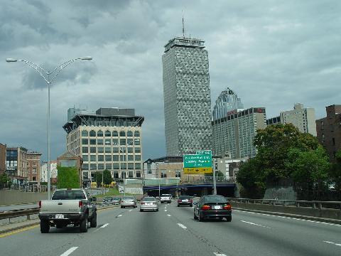
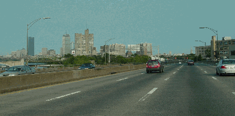
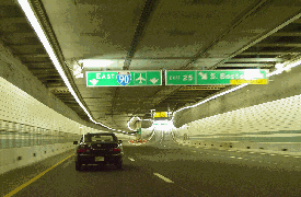
This 2005 photo shows the eastbound Massachusetts Turnpike (I-90) approaching EXIT 22 (Prudential Center / Copley Square) and the "Prudential Tunnel" in Boston. (Photo by Jim K. Georges.)
|
|
|
|
|
|
|
|
|
 |
|
|
|
|
 |
|
|
|
|
|
|
|
|
|
138.1 miles (222.3 kilometers)
1955-2003
|
|
|
|
|
|
|
|
|
 |
|
|
|
|
|
|
|
|
|
$7.10 (eastbound)
$10.60 (westbound)
|
|
|
|
|
|
|
|
|
|
|
Passenger car EZ-Pass toll:
|
|
|
|
|
|
|
|
|
$6.85 (eastbound)
$9.85 (westbound)
|
|
|
|
|
|
|
|
|
|
|
|
|
|
|
|
|
 |
|
|
|
|
|
PLANNING AN EXPRESSWAY FROM BOSTON TO THE WEST: As early as 1948, the Massachusetts Department of Public Works (MassDPW) proposed a controlled-access route to link downtown Boston with its rapidly growing western suburbs. Eventually, the "Western Expressway" was to be the Interstate highway continuing along the US 20 corridor to Worcester, Springfield and points west.
|
|
|
|
|
|
|
|
|
|
|
|
|
|
The 1948 Master Highway Plan for the Boston Metropolitan Area described the Western Expressway as follows:
The heaviest desire line of travel in the metropolitan area is in the western section. Traffic in this area is served by the Worcester Turnpike, Beacon Street, Commonwealth Avenue, Washington Street, North Beacon Street, Arsenal Street and Western Avenue. While several of these arteries are multi-lane facilities, they cannot be improved to expressway standards except at tremendous cost for rights-of-way. An alternate solution was adopted involving the construction of a new expressway through this area to supplement MA 9, and to connect with US 20 and MA 30. It is recommended that this expressway be considered as the new limited-access Interstate highway via Worcester to the west.
Under the original plan, the 7.7-mile-long, six-lane Western Expressway was to carry approximately 55,000 vehicles per day (AADT). Beginning at the Inner Belt (unbuilt I-695) near the River Street Bridge in Cambridge, the Western Expressway was to cross the Charles River several times between Cambridge, Boston and Watertown before terminating at Newton.
Interchanges were to be constructed at the following locations:
Inner Belt (I-695), Cambridge
River Street, Cambridge
North Harvard Street, Boston
Arsenal Street, Watertown
North Beacon Street, Boston
Galen Street, Watertown
Waltham Street, Newton
River Street and Rumford Avenue, Newton
Yankee Division Highway (I-95 / MA 128) and Commonwealth Avenue (MA 30), Newton
A future extension of the Western Expressway was to continue west along the US 20 corridor, but details on this extension were vague. However, both the expressway and its western extension across Massachusetts to the New York State border were included in preliminary Interstate highway plans developed by the Federal Bureau of Public Roads (BPR).
|
|
|
|
|
|
|
|
|
|
|
|
|
|
|
|
|
The proposed $18.1 million Western Expressway did not include an eastern extension to downtown Boston and the Central Artery (I-93), a fact that was not lost on MassDPW commissioner William F. Callahan. Callahan, whom many portrayed as Boston's version of Robert Moses, saw the expressway as an opportunity to create an "economic lifeline" for Boston, whose fortunes sank precipitously with the decline of rail and sea freight, and the lack of modern highway access.
A report published by the MassDPW described the need for the highway as follows:
|
|
|
|
|
|
|
|
|
|
|
|
|
|
|
|
|
|
|
|
|
|
|
|
|
The present east-west interstate highway between
Boston and the New York state line
is obsolete, inadequate, deficient and outmoded from a standpoint of traffic safety, efficiency, public convenience and modern engineering standards. This highly important route, which is vital to the highway transportation needs of the state and nation, has been overtaken by rapid functional obsolescence.
Governor Paul Dever, a fellow Democrat, liked the idea of a modern highway link from Boston to the west, as did other state lawmakers. However, the state's precarious economic position, aggravated by its heavy debt load, precluded more traditional means of financing the project.
|
|
|
|
|
|
|
|
|
|
|
|
|
|
 |
|
 |
|
|
|
|
|
|
|
|
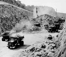
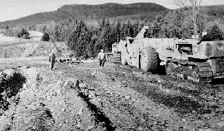
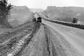
Two views of the Massachusetts Turnpike under construction in Brimfield (left photo) and Westfield (right photo). The initial 123 miles of the Mass Pike, from West Stockbridge to Weston, was completed over a 26-month period from 1955 to 1957. (Photos by Massachusetts Turnpike Authority.)
|
|
|
|
|
|
|
|
|
|
|
|
|
|
|
|
|
|
|
|
CALLAHAN'S TOLL ROAD: In 1952, Callahan proposed the creation of a new authority to oversee the proposed turnpike, Initially called the Boston-Springfield Highway Authority, it was renamed the Massachusetts Turnpike Authority when Callahan introduced (and Springfield representative Phillip Kimball supported) legislation for its creation in the Massachusetts State House.
|
|
|
|
|
|
|
|
|
|
|
|
|
|
|
|
|
The legislation "authorized and empowered" the authority "to construct, maintain, repair and operate
a toll express highway
from a point in the vicinity of the city of Boston to a point at or near the New York State border." The only power that the state had was the gubernatorial appointment of the authority's three-member board to eight-year terms. When the legislation passed, Governor Dever named Callahan - who was already MassDPW commissioner - the chairman of the Massachusetts Turnpike Authority. (Callahan subsequently resigned his MassDPW post.)
DESIGN AND INITIAL CONSTRUCTION: The proposed Massachusetts Turnpike was to incorporate not only the original Western Expressway route, but also another expressway route - the Springfield Bypass - that was to provide a bypass of the existing US 20 through the Springfield area. In accordance with the 1944 Federal Highway Act, the authority drew a tentative line connecting the cities of Boston, Worcester and Springfield.
Expressway connections were to be provided with the following routes:
Central Artery (now I-93)
Inner Belt (unbuilt I-695)
Yankee Division Highway (MA 128, now I-95)
Worcester-Providence Turnpike (MA 146)
Worcester Expressway connection (MA 12, now I-290 / I-395)
Wilbur Cross Highway (MA 15, now I-84)
Springfield Expressway connection (now I-291)
Proposed Pittsfield Expressway connection (unbuilt US 7)
The turnpike was to accommodate eight lanes (four in each direction) from Boston west to Springfield, and six lanes (three in each direction) from Springfield west to the Berkshire Extension of the New York State Thruway; it was to have ten-foot-wide left and right shoulders throughout the entire length. Grades on the new turnpike were not to exceed three percent.
Callahan divided the project into two phases in order to ease the financial burden on the new authority. This decision also allowed the authority to work out an optimal alignment for the turnpike. The two sections each had a unique character, and each demanded the undivided attention of the authority:
Along the 123.3-mile-long western section from West Stockbridge to Weston, which largely passed through undeveloped farmland, interchanges were widely spaced. Tolls were to be collected on a ticket system at each interchange.
Along the 11.3-mile-long eastern section from Newton to Boston, interchanges were more closely spaced. Two barrier tolls (one in Newton, the other in Boston) were to handle cash collections.
In May 1954, the Massachusetts Turnpike Authority floated a $239 million bond issue to finance the proposed turnpike. Following the success of other turnpike issues in the Northeast, the Mass Pike bonds were sold out in three hours. The authority was projected to take in $500 million in revenue from both tolls and turnpike concessions over a 30-year period.
Construction of the initial section of turnpike from West Stockbridge to Weston began in earnest in January 1955. The Massachusetts Turnpike Authority let out simultaneous contracts for multiple road sections, ensuring that the turnpike would not only be built expeditiously, but also generate revenue as early as possible. The original turnpike opened on May 15, 1957 (only 26 months after construction began) at a cost of $257 million.
The original turnpike was not constructed to the original six-lane and eight-lane configurations, but to a four-lane configuration (two lanes in each direction) throughout the 123 miles. However, other specifications - 12-foot-wide lanes, 10-foot-wide inside and outside shoulders, 1,200-foot-long acceleration and deceleration lanes, and a guardrail-separated median - complied with modern turnpike standards. Bridges were constructed to permit an additional travel lane in each direction. The Massachusetts Turnpike Authority also constructed service areas to serve motorists while generating additional revenue.
|
|
|
|
|
|
|
|
|
|
|
|
|
|
 |
|
 |
|
|
|
|
|
|
|
|
|
|
|
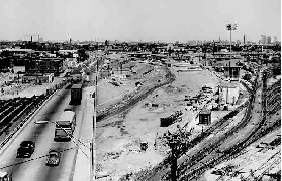
LEFT: This photo from the early 1960s shows construction of the Boston Extension of the Massachusetts Turnpike. This section, which paralleled the New York Central Railroad (now the MBTA Framingham-Worcester Line), was completed in 1965. RIGHT: This photo from the late 1960's shows the widening project that brought the Mass Pike from four to six lanes between EXIT 9 (I-84) in Sturbridge and EXITS 14-15 (I-95 / MA 128 / MA 30) in Weston. (Photos by Massachusetts Turnpike Authority.)
|
|
|
|
|
|
|
|
|
|
|
|
|
|
|
|
|
|
|
|
SHOULD THE BOSTON EXTENSION BE FREE OR TOLL? Since its creation, the Turnpike Authority had intended to extend the original turnpike from its terminus at the Yankee Division Highway (MA 128) east to downtown Boston. While no one doubted the need for an expressway between Newton and Boston, the controversy focused on the following question, "Should the road be financed with Turnpike Authority bonds backed by tolls, or should it be constructed on a 'pay-as-you-go' basis by the MassDPW?" From 1955 to 1962, there seemed no clear answer to this question.
|
|
|
|
|
|
|
|
|
|
|
|
|
|
SHOULD THE BOSTON EXTENSION BE FREE OR TOLL? Since its creation, the Turnpike Authority had intended to extend the original turnpike from its terminus at the Yankee Division Highway (MA 128) east to downtown Boston. While no one doubted the need for an expressway between Newton and Boston, the controversy focused on the following question, "Should the road be financed with Turnpike Authority bonds backed by tolls, or should it be constructed on a 'pay-as-you-go' basis by the MassDPW?" From 1955 to 1962, there seemed no clear answer to this question.
At the onset, Callahan proposed that the proposed Boston Extension of the Massachusetts Turnpike cut through downtown Boston and end at the John F. Fitzgerald Expressway (Central Artery) then under construction. Callahan's successor at the MassDPW, John A. Volpe, had a different vision. He proposed that the road - the free "Western Expressway" - be constructed from Route 128 east to the proposed Inner Belt, some two miles west of the Central Artery. Callahan enjoyed an early advantage: while Volpe's Western Expressway and Inner Belt existed only as preliminary plans on paper, the Central Artery was well on the way to becoming reality, and plans for the turnpike extension were in the advanced planning stages.
Callahan had also planned to capitalize on the decline of the railroads. During the 1950's, the Boston and Albany Railroad first put its 28-acre Back Bay rail yard up for sale, then cut back service along its Boston-Worcester commuter line, giving Callahan a readily available right-of-way (and potentially minimizing community impact and opposition). In 1956, Callahan met in secret with Alfred Perlman, the president of the Boston and Albany Railroad, to discuss his plan to acquire the right-of-way. The news of the secret meeting had been leaked to The Newton Graphic, unleashing opposition in that town.
CALLAHAN STUMBLES
AND FIGHTS BACK: Just as it appeared the Callahan had gained the upper hand, two developments in 1956 had negative implications for his turnpike extension. They were as follows:
During the spring of 1956, the Prudential Insurance Company announced its intentions to purchase the 28-acre Back Bay rail yard. The deal was touted as a critical step in the development of the "new Boston." However, the property was right in the path of the proposed turnpike extension to the Central Artery.
On June 28, 1956, President Dwight Eisenhower signed the Federal Highway Act into law, granting states the ability to construct new highways while paying only ten percent of their cost. The Federal government was to pay the remaining 90 percent of the cost of the new roads.
With the promise of new highways paid for by "10-cent dollars," the estimated $150 million price tag for the turnpike extension no longer seemed so lofty. This provided Volpe the ammunition to aggressively push not only for his free Western Expressway, but also for other highways proposed in the 1948 Master Highway Plan. Robert Kretschmar, executive director of the Massachusetts chapter of the American Automobile Association (AAA), joined Volpe in support of a freeway (rather than a turnpike) as follows:
The Bay State's greatest highway need is for a limited access expressway to serve all the people who live in the suburban towns west of Boston and must commute between their homes and the city. A free public artery will serve the needs of Greater Boston residents far better than a toll road.
Callahan promptly responded to these setbacks as follows:
In the closing days of 1956, and throughout 1957, Callahan entered into negotiations with the Boston and Albany Railroad, and with Prudential over the Back Bay property. After his initial cool response to the Prudential deal, he realized that both the turnpike extension and the Prudential development were crucial to Boston's renaissance, and held that the two projects should not be mutually exclusive. Both the Massachusetts Turnpike Authority and Prudential developed engineering studies for the development, the turnpike and its access ramps.
On the Volpe front, Callahan went on the offensive, claiming that due to a lack of funds - only $525 million out of an expected $850 million had been allocated for implementing the Master Highway Plan - there would be "no road for ten years" along the Newton-Boston corridor. While the MassDPW responded that the Federal Bureau of Public Roads (BPR) had planned to appropriate the entire $850 million amount, Callahan's Democratic allies on Beacon Hill - notably Governor Furcolo - ignored calls from officials in Boston and Newton to oppose the extension of the Massachusetts Turnpike into downtown Boston.
In the fall of 1958, Callahan cleared another major stumbling block. The original charter of the Massachusetts Turnpike Authority required that the MassDPW, an agency that had grown somewhat antagonistic to Callahan's desires, approve any alignment. Fortunately for Callahan, Anthony DiNatale, the new MassDPW commissioner and a close acquaintance of the turnpike commissioner, was heavily involved in other projects around the state. Seeking an expeditious resolution, DiNatale approved the alignment of the Boston Extension along the Boston and Albany railroad right-of-way to the Central Artery. It appeared that construction of the turnpike would be imminent, and that the worst fears of those who lived along the route in Boston and Newton would be realized.
|
|
|
|
|
|
|
|
|
|
|
|
|
|
 |
|
 |
|
|
|
|
|
|
|
|
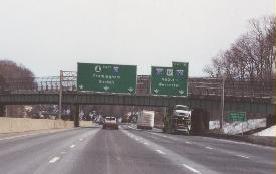
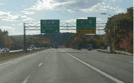
These 2001 photos show the eastbound Mass Pike (I-90) at EXIT 10 (I-290 / I-395 / Worcester Expressway) in Auburn (left photo), and at EXIT 11A (I-495 / Outer Circumferential Highway) in Hopkinton (right photo). (Photos by Steve Anderson.)
|
|
|
|
|
|
|
|
|
|
|
|
|
|
|
|
|
|
|
|
MORE OBSTACLES FOR CALLAHAN: By the end of the 1950s, it appeared that Callahan was ready to build his Boston Extension. However, the disappointing performance of the initial 123-mile-long turnpike, coupled with the moribund market for new turnpike revenue bonds (thanks to the development of the pay-as-you-go Interstate highway system), posed new financing challenges.
|
|
|
|
|
|
|
|
|
|
|
|
|
|
New challenges lay ahead for Callahan in the spring of 1960. At that time, former MassDPW commissioner Volpe, who was now chairman of the Greater Boston Chamber of Commerce, announced his gubernatorial candidacy to run as a "reform Republican" who, in Eisenhower fashion, would spend aggressively on public works projects. While Volpe won the gubernatorial campaign, Callahan had the support of newly elected President John F. Kennedy, a fellow Democrat. Callahan had another important ally - Fred Smith, the vice president of Prudential Insurance Company - to thwart Volpe's repeated overtures to stop construction of the turnpike (and thereby access to the Prudential development.)
By January 1961, Volpe yielded to Callahan, admitting that it "was a choice between the Prudential and the freeway." One month later, Mayor Donald Gibbs, who stood alone in his opposition to the turnpike through Newton, caved in and entered negotiations with the Massachusetts Turnpike Authority to leverage some concessions, including air rights over the turnpike and dropping plans for a service area in Newton. The Newton-Boston route was to be constructed as a toll road.
Nevertheless, Callahan faced the problem of financing the Boston Extension, a problem that was aggravated by two failed attempts at selling Massachusetts Turnpike Authority bonds. Volpe, his patience tested by the failed sale, joined the Greater Boston Chamber of Commerce in resuming his calls for a freeway in the following joint statement:
Highway planning and construction to the west of Boston are too important to be left to the uncertain vicissitudes of the bond market for another interminable period. Seven valuable years have already been lost, and we strongly urge the State Department of Public Works and all those involved to proceed ahead in the fastest possible manner.
In the fall of 1961, Volpe ordered MassDPW to revive engineering studies on the free "Western Expressway" proposal, in defiance of the Massachusetts Turnpike Authority's legislative authorization to construct a toll road from Route 128 to downtown Boston, and asked Attorney General McCormack his opinion whether the legislative authorization constituted an exclusive privilege. However, McCormack held that the Massachusetts Turnpike Authority - and no one else - had the authority to construct and maintain the Newton-Boston route.
FINALLY, A RESOLUTION ON THE EXTENSION: The third time proved the charm in the municipal bond market for Callahan. In January 1962, the Massachusetts Turnpike Authority successfully sold $180 million of bonds that featured a two-tier structure and the promise of a deferred lump-sum payment to lure investors. On March 5, 1962, less than two months after the bond sale, the authority broke ground on the Boston Extension.
Callahan did not live to see his turnpike completed. In September 1964, five months after Callahan died, the Boston Extension was completed to east to EXIT 18 (Allston-Brighton-Cambridge). The entire 135-mile length of the Massachusetts Turnpike opened to traffic on February 18, 1965 with the completion of the Prudential Tunnel and the interchange with the Central Artery (I-93).
Six lanes (three in each direction) were provided from the Route 128 barrier toll plaza east to Newton Center (EXIT 17), and eight lanes (four in each direction) were provided from Newton Center east to the Central Artery. Along the Boston Extension, the lack of adequate shoulders and acceleration-deceleration lanes were characteristic of early-Interstate era construction through urban areas.
Not all of the Boston and Albany Railroad right-of-way had been acquired for the Boston Extension. Limited commuter rail service continued along this corridor after the turnpike opened, and service has since been expanded as part of the MBTA (Massachusetts Bay Transportation Authority) Framingham-Worcester commuter line.
|
|
|
|
|
|
|
|
|
|
|
|
|
|
|
 |
|
|
|
|
|
|
|
|
This 2003 photo shows the eastbound Massachusetts Turnpike (I-90) just beyond the toll plaza at EXIT 18 (Allston-Brighton-Cambridge). (Photo by Jim K. Georges.)
|
|
|
|
|
|
|
|
|
|
|
|
|
|
|
|
|
|
|
|
|
|
|
|
|
|
|
|
|
|
IMPROVEMENTS TO THE MASS PIKE: To accommodate ever-increasing traffic demands in the New York-to-Boston corridor, and to provide improved connections to other controlled-access highways, the Massachusetts Turnpike Authority has completed the following improvement projects over the years:
|
|
|
|
|
|
|
|
|
|
|
|
|
|
In 1965, improvements were made at EXIT 10 (I-290 / I-395 / MA 12) in Auburn to provide connections to the newly built I-290 (Worcester Expressway), and future connections to I-395.
In 1969, a new interchange in Hopkinton - EXIT 11A - provided a connection to the newly constructed I-495 (Outer Circumferential Highway), and furnished a connection for long-distance travelers to northern New England and Cape Cod.
In 1970, the Massachusetts Turnpike Authority widened the original turnpike from EXIT 9 (I-84 / Wilbur Cross Highway) in Sturbridge east to EXITS 14-15 (I-95 / MA 128 / Yankee Division Highway) in Weston.
In 1998, after ten years of study and construction, a new $33 million interchange in Millbury - EXIT 10A - provided a connection to MA 146 (Worcester-Providence Turnpike), which was upgraded to a freeway facility.
The Massachusetts Turnpike Authority upgraded facilities and constructed new buildings at the nine service plazas. McDonald's Corporation, which won the contract for the Mass Pike concessions from Host Marriott in 2000, added new services to the plazas.
Along various sections of the mainline turnpike, the Massachusetts Turnpike Authority is currently rehabilitating bridges; adding a new concrete "Jersey" median barrier; and improving lighting, signing and other safety features. The most recent project - a $12 million project completed in 2004 - involved the replacement of a 27-inch-high steel guardrail with a 42-inch-high concrete "Jersey" barrier.
|
|
|
|
|
|
|
|
|
|
|
|
|
|
 |
|
 |
|
|
|
|
|
|
|
|
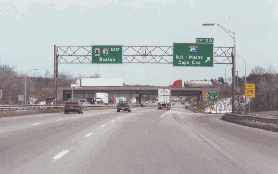
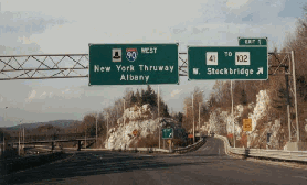
LEFT: This 2001 photo shows the westbound Mass Pike (I-90) at EXIT 9 (I-84 / Wilbur Cross Highway) in Sturbridge. (Photo by Mike Tantillo.) RIGHT: This 2000 photo shows the westbound Mass Pike (I-90) at EXIT 1 (MA 41) in West Stockbridge. The Mass Pike continues west as the Berkshire Thruway (I-90) into New York State. (Photo by Douglas Kerr, gribblenation.com.)
|
|
|
|
|
|
|
|
|
|
|
|
|
|
|
|
|
|
|
|
THE FINAL SECTION OF I-90: As early as 1957, the MassDPW recognized the eventual need for a third tunnel under Boston Harbor to supplement the Sumner and Callahan tunnels, as well as the Tobin Bridge. The completion of the Massachusetts Turnpike and other roads, as well as growth in downtown Boston and at Logan Airport, had taxed the capacity of the existing facilities by 1970.
|
|
|
|
|
|
|
|
|
|
|
|
|
|
During the early 1970s, the Boston Transportation Planning Review (BTPR) evaluated several proposals for a third tunnel under Boston Harbor. At that time, Governor Sargent recommended the construction of a special-use tunnel (for transit and emergency vehicles only) from South Boston to Logan Airport, and sought 90 percent Federal funding for the tunnel. John A. Volpe, then Transportation Secretary under President Nixon, granted the I-90 designation for the proposed extension. From the mid-1970's through the early 1980's, the MassDPW evaluated five "Third Harbor Tunnel" alternative alignments in conjunction with an underground replacement of the Central Artery (I-93).
Fred Salvucci, who served as transportation secretary under Governor Michael Dukakis, quietly worked to seek support from a broad coalition to construct a combined Central Artery replacement and "Third Harbor Tunnel." Salvucci, whose grandmother was evicted from a Boston neighborhood to make way for the Boston Extension in 1962, saw to it that his plan would not destroy neighborhoods, particularly in politically sensitive East Boston. He also saw the potential benefits of the tunnel and its approaches for redeveloping South Boston.
Despite friction from Governor Dukakis, Salvucci sold the governor on the ambitious plan in 1983. On April 2, 1987, after four years of rancorous debate (and over the veto of President Ronald Reagan), Congress approved the "Big Dig" as part of an omnibus transportation bill.
DESCRIPTION OF THE PROJECT: In a variation of "tunnel alternative 3," the Massachusetts Turnpike (I-90) was to be extended east of the Central Artery for three and one-half miles. The turnpike was to cross under Fort Point Channel, and re-emerge in South Boston before making the 8,500-foot-long journey under Boston Harbor through the four-lane Ted Williams Tunnel. The turnpike extension was to resurface as a six-lane route through Logan Airport before terminating at the East Boston Expressway (MA 1A).
On December 19, 1991, Governor William Weld broke ground for the Ted Williams Tunnel and the I-90 extension to Logan Airport. To expedite the work, construction crews dug a trench and placed 12 pre-cast tunnel sections into the trench. Under separate contracts, crews constructed the approaches to South Boston and East Boston. The two sides were connected in the summer of 1995.
On December 15, 1995, the Ted Williams Tunnel opened to commercial and transit vehicles. (At the onset, passenger cars were limited to using the tunnel during off-peak periods.) The legendary Boston Red Sox slugger joined Governor Weld for the dedication ceremonies.
A TECHNOLOGICAL CHALLENGE: To link the Massachusetts Turnpike and I-93 with the Ted Williams Tunnel approach in South Boston, construction crews had to dig a tunnel underneath nearby Fort Point Channel. Including through travel lanes and ramps, the proposed 1,100-foot-long tunnel was to have 11 lanes.
Before digging began, workers had to find a way to stabilize the soft soil, which was actually fill dumped into Boston Harbor during the nineteenth century. Facing cost overruns of nearly $500 million on the Fort Point Channel section, engineers discovered a new method of soil stabilization by way of Japan: a three-step process involving liquefying the soil, mixing the soil with concrete and freezing the soil-concrete mix. Large machines churned the mixture churned the soil, concrete and cold saltwater through 120-foot-tall booms.
The original design for the Fort Point Channel link called for the conventional floating and installation of six 27-foot-high, steel-and-concrete immersed tunnel tubes (ITT's), as had been done with the Ted Williams Tunnel several years earlier. However, the low clearance of the existing bridges across Fort Point Channel, as well as the proximity of nearby rail and subway lines, precluded such an installation. To circumvent these problems, crews constructed the six twin-tube ITT sections on site. Doing so required the construction of cofferdams and nearly one-half mile of slurry walls. Four of the six ITT sections were placed under the Fort Point Channel, requiring the temporary relocation of water flow through the channel. The tubes were then floated to the bottom of the channel with the falling tide. The remaining ITT sections west of the channel were "jacked" into place underneath the Amtrak-MBTA commuter rail tracks, and just above the MBTA-Red Line subway. Engineers dug 110 concrete shafts (each six feet in diameter) more than 100 feet into the bedrock to provide additional support for the six ITT sections. All six ITT sections were set into place by late 2000.
Once the ITT sections were in place, workers raced against the clock to connect the six sections to the Ted Williams Tunnel approach and the reconstructed I-90 / I-93 interchange, and to plug up leaks with a cement and foam-like grout. The final section of the Massachusetts Turnpike opened during the weekend of January 18-19, 2003, finally linking I-90 to the Ted Williams Tunnel and Logan International Airport (where Massport officials had just completed a $176 million overhaul of the airport's roadway system). The $6.5 billion final cost of the final 3.5-mile-long I-90 link (including the Ted Williams Tunnel) made it the most expensive highway per mile in North America.
|
|
|
|
|
|
|
|
|
|
|
|
|
|
 |
|
 |
|
|
|
|
|
|
|
|
BEFORE AND AFTER
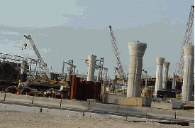
LEFT: This 2000 photo shows the construction of columns for elevated roadways and ramps at the rebuilt I-90 / I-93 interchange. RIGHT: This 2003 photo shows the recently completed Fort Point Tunnel section of the Massachusetts Turnpike connecting the I-90 / I-93 interchange with South Boston. (Photos by Jim K. Georges.)
|
|
|
|
|
|
|
|
|
|
|
|
|
|
|
|
|
|
|
|
THE MASS PIKE TODAY: According to the Massachusetts Highway Department (MHD), the Massachusetts Turnpike carries approximately 20,000 vehicles per day (AADT) at the Massachusetts-New York border, rising to approximately 50,000 vehicles per day through the Springfield area, approximately 85,000 vehicles per day in the Worcester area, and 105,000 vehicles per day through the city of Boston.
|
|
|
|
|
|
|
|
|
|
|
|
|
|
During the early 1990s, the speed limit on the Massachusetts Turnpike was raised to 65 MPH from the Massachusetts-New York border east to EXIT 10 (I-290 / I-395 / MA 12) in Auburn. The 65 MPH limit was extended east to EXIT 14 (I-95 / MA 128 / Yankee Division Highway) during the mid-1990s.
HOW DID THE MASS PIKE GET ITS LOGO? The original logo for the Massachusetts Turnpike depicted Paul Revere on horseback with the words "Massachusetts Turnpike" in a circle around him. Sometime in the late 1950's, the logo was changed to a Pilgrim hat and Indian arrow, commemorating the arrival of the Pilgrims in 1620. (However, some say that Callahan created the "arrow through the Pilgrim hat" logo to symbolize the power of the Irish piercing the traditional WASP lock on political power in Massachusetts.) The logo was streamlined to a simple black Pilgrim hat during the late 1990s.
|
|
|
|
|
|
|
|
|
|
|
|
HOV ON THE MASS PIKE? In the early 1990's, the Massachusetts Turnpike Authority studied the possibility of constructing a new reversible center lane for HOV use from EXIT 14 (I-95 / MA 128 / Yankee Division Highway) east to EXIT 18 (Allston-Brighton), and two new HOV lanes from EXIT 18 east to EXIT 24 (I-93 and US 1 / Central Artery). The project, which was estimated to cost $150 million and slated for completion by 2000, was shelved in a favor of a more cost-effective plan to construct 1,500 new park-and-ride spaces.
|
|
|
|
|
|
|
 |
|
|
|
|
|
|
|
|
|
|
MAKING TOLLS LESS TAXING: In a joint venture with Fleet Bank (now part of Bank of America), the Massachusetts Turnpike Authority implemented the Fast Lane electronic toll collection system in 1998. At that time, the authority also eliminated tolls for automobiles traveling the mainline turnpike between EXIT 1 (MA 41) in West Stockbridge and EXIT 6 (I-291) in Springfield, and for all vehicles at EXIT 16 (MA 16) in Newton. One year later, the Fast Lane system became interoperable with the EZ-Pass electronic toll collection system.
On October 18, 2006, the authority voted to eliminate tolls along the original 123-mile-long section from West Stockbridge to Weston. The $199 million in outstanding debt along this section is likely to be paid from the authority's cash revenues, as well as from bonds secured by contract revenue from the turnpike service areas. The tolls were due to be removed in 2007, but as of mid-2008 tolls still were applied for travel between EXIT 6 and EXIT 14 (I-95 / MA 128).
FUTURE INTERCHANGES? Local officials have proposed that new interchanges be constructed to spur development. The interchanges would be built at EXIT 2A (US 20 and MA 8) in West Becket, EXIT 2B (MA 23) in Blandford, EXIT 8A (MA 19) in Warren, and EXIT 9A (MA 56) in Oxford. The city of Springfield owns land around the Blandford site, while the Massachusetts Turnpike Authority owns land around the Warren and Oxford sites.
|
|
|
|
|
|
|
|
|
|
|
|
|
|
|
 |
|
|
|
|
|
|
|
|
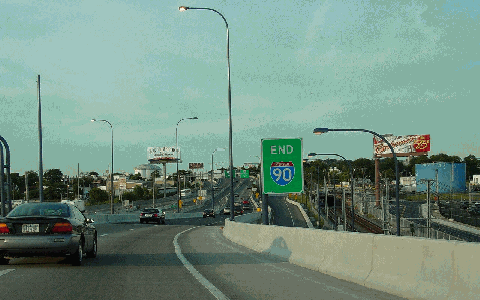
THE END OF I-90: This 2003 photo shows the new eastern terminus of the Massachusetts Turnpike (I-90) at the East Boston Expressway (MA 1A) just beyond Logan International Airport. (Photo by Jim K. Georges.)
|
|
|
|
|
|
|
|
|
|
|
|
|
|
|
|
|
|
|
|
"BIG DIG" TUNNEL ROOF COLLAPSE PROMPTS INVESTIGATION: Late in the evening on July 10, 2006, a three-ton concrete ceiling panel measuring 20 feet by 40 feet collapsed onto a car traveling on the two-lane ramp connecting northbound I-93 (Southeast Expressway) to eastbound I-90 (Massachusetts Turnpike) in South Boston, which is known as "Ramp A." The collapse killed a passenger in the car, while the motorist escaped with minor injuries.
|
|
|
|
|
|
|
|
|
|
|
|
|
|
Officials promptly closed not only "ramp A," but also "ramp D" (connecting westbound I-90 to both directions of I-93) and the I-90 tunnel beneath Fort Point Channel. However, they did not close the nearby Ted Williams Tunnel because its design did not require the use of heavy ceiling panels.
Immediately after the collapse, Governor Mitt Romney dismissed Turnpike Authority Chairman Matthew Amorello and took over the post-collapse investigation. Engineers pinpointed the failure to stress in the vertical ceiling bolts and inadequately applied epoxy used to hold up the bolts. Upon further inspection, engineers found that a total of 3,300 bolts needed to be replaced. They also found that hundreds of additional diagonal bolts needed to be installed to prevent the collapse of additional concrete ceiling tiles during an earthquake. The improvements took nearly one year to complete; the last section to be remediated - the I-90 HOV eastbound tunnel - was reopened on June 2, 2007.
|
|
|
|
|
|
|
|
|
|
|
|
|
|
|
|
|
|
|
 |
|
|
|
 |
|
|
|
|
|
SOURCES: Master Highway Plan for the Boston Metropolitan Area, Massachusetts Department of Public Works (1948); "New Toll Road" by John H. Fenton, The New York Times (6/22/1952); "Trans-State East-West Toll Road Study," Massachusetts Department of Public Works (1952); "Bay State's Turnpike Link" by Joseph C. Ingraham, The New York Times (5/12/1957); "Boston Survives a Renewal Crisis" by John H. Fenton, The New York Times (3/05/1961); "Massachusetts Turnpike Chief Criticized in Raising Scandals" by Anthony Lewis, The New York Times (6/20/1961); "A Report of Progress," Massachusetts Department of Public Works (1962); "Inner Belt and Expressway System," Massachusetts Department of Public Works (1962); "Turnpike Air Rights May Provide Revenue" by Edward C. Burks, The New York Times (5/30/1965); Recommended Highway and Transit Plan, Massachusetts Department of Public Works (1968); "The Massachusetts Highway Story," Massachusetts Department of Public Works (1969); Boston Transportation Planning Review: Final Study Summary Report, Massachusetts Department of Public Works (1972); "Two Key Interstate Links in Massachusetts" by John A. Volpe, The New York Times (2/24/1984); "Central Artery (I-93) and Third Harbor Tunnel (I-90), Boston, Massachusetts: Final Environmental Impact Statement and Section 4(f) Evaluation," Federal Highway Administration, Massachusetts Department of Public Works and Massachusetts Turnpike Authority (1985); "Why We Don't Fly Out of Hegenberger Airport" by Peter J. Howe, The Boston Globe (4/23/1989); "Central Artery (I-93) and Third Harbor Tunnel (I-90), Boston, Massachusetts: Final Supplemental Environmental Impact Statement," Federal Highway Administration, Massachusetts Department of Public Works and Massachusetts Turnpike Authority (1991); "High Occupancy Lane Feasibility Study," Massachusetts Turnpike Authority (1994); "Six Lanes, Five Miles, A Decade of Controversy: The Mass Pike Through Newton" by Toby Berkman, The Concord Review (1997); Divided Highways by Tom Lewis, Viking-Penguin Books (1997); "The Big Dig," The History Channel (1998); Rescuing Prometheus by Thomas P. Hughes, Pantheon Books (1998); "The Last Road to Boston" by Yanni Tsipis, Massachusetts Institute of Technology (1999); "Links Set for Pike and Tunnel" by Thomas C. Palmer, Jr., The Boston Globe (6/09/2001); "Frequent Pike Users May Get Toll Breaks," WCVB-TV (8/09/2001); "Leak Sinks Projected Opening of I-90 Link" by Thomas C. Palmer, Jr., The Boston Globe (10/19/2001); The Big Dig by Dan McNichol, Silver Lining Books (2001); "Hike Exacts Toll from Hub Motorists" by Robin Washington, The Boston Herald (7/02/2002); Building the Mass Pike by Yanni Tsipis, Arcadia Publishing (2002); "Pike Extension Opening Will Amaze, Official Says" by Doug Hanchett, The Boston Globe (1/12/2003); "Tunnel Connecting Ted Williams Tunnel, Turnpike Opens," The Boston Globe (1/19/2003); "Boston Unveils $6.5 Billion Section of Central Artery Job" by William J. Angelo, Engineering News-Record (1/20/2003); "Springfield Amassing Blandford Property" by Anthony Flint, The Boston Globe (5/12/2003); "Plan Would Remove Most Tolls on Pike by Brian McGrory, The Boston Globe (8/29/2003); "Section of Ceiling Collapses in Tunnel" by John R. Ellement, The Boston Globe (7/11/2006); "Key Ramp May Stay Shut Past Holiday" by Mac Daniel and Raja Mishra, The Boston Globe (8/23/2006); "Romney Says Connector Needs More Supports" by Mac Daniel, The Boston Globe (9/01/2006); "Final Big Dig Section To Open" by Sean P. Murphy, The Boston Globe (6/02/2007); "Turnpike Boss OK's Studying Interchange" by Betty Lilyestrom, The Worcester Telegram and Gazette (4/24/2008); Massachusetts Highway Department; Massachusetts Turnpike Authority; Steve Alpert; John F. Carr; Jay Hogan; Scott Kozel; Dan Moraseski; Scott Moore; Mike Natale; Fred Salvucci; George Sanborn; Paul Schlichtman; Alexander Svirsky.
I-90 shield by Ralph Herman.
Massachusetts Turnpike shield by James Lin.
Lightposts by Millerbernd Manufacturing Company.
|
|
|
|
|
|
|
|
|
|
|
|
|
|
|
|
 |
|
 |
|
|
|
|
|
|
|
|
|
|
|
|
|
 |
|
|
|
|
|
|
|
|
|
 |
|
|
|
|
|
|
|
|
|
 |
|
|
|
|
|
|
|
|
 |
|
|
|
|
|
|
|
|
 |
|
|
|
|
|
|
|
|
|
|
|
|
Site contents © by Eastern Roads. This is not an official site run by a government agency. Recommendations provided on this site are strictly those of the author and contributors, not of any government or corporate entity.
|
|
|
|
|
|
|
|
|
|