
|
|
||
|
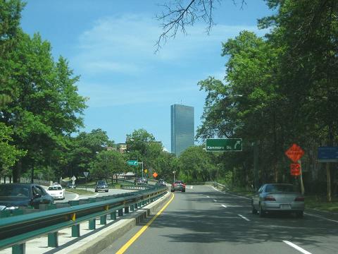
This 2015 photo shows the eastbound Storrow Drive at the exit for Kenmore Square (Charlesgate / Bowker Overpass). (Photo by Steve Anderson.) |
||
|
Length: |
||
|
2.0 miles (3.2 kilometers) |
||
|
Passenger cars only. Height restrictions apply. |
||

|
BUILDING THE CHARLES RIVER ESPLANADE: The first mention of a highway along Boston's Charles River waterfront came in 1929, when the newly created Metropolitan District Commission (MDC) hired landscape architect Arthur Shurcliff to devise plans for "Charlesbank." The Charlesbank development was a comprehensive plan to widen the waterfront park designed by noted landscape architect Frederick Law Olmstead, and supported originally in the 1900s and 1910s by prominent lawyer, investment banker, and Boston City Council member James Storrow. In addition to new playground space, marinas, and bathing facilities, the updated plan called for a four-lane, grade-separated parkway for automobile-exclusive use. The parkway was to stretch from the Longfellow Bridge west to the Boston University Bridge, where it was to connect to Soldiers Field Road. |
||
|
When James Storrow died in 1926, his wife, Helen Obsorne Storrow, became active in the plans for Charlesbank. In 1931, Storrow $1 million to the Commonwealth of Massachusetts to complete the Charlesbank development, with the stipulation that none of the widened parkland be used for a highway. Despite the objections raised by Storrow, city officials and business leaders continued to press for a waterfront highway. In 1936, the Boston Chamber of Commerce announced a set of recommendations designed to improve traffic flow, and in turn increase business activity and real estate values. The highway, which was planned initially as "Embankment Road," was singled out by the Chamber such that it formed a subcommittee to petition the city for its construction. |
||
|
The traffic analysis indicates a very heavy desire line paralleling the Charles River Basin. Much of this traffic is predominantly local in character, and is now using Commonwealth Avenue and Beacon Street. There is considerable cross conflict on these streets which delays the major stream of traffic moving eat and west. |
||
|
This project, in supplementing the Belt Route, will serve as useful function in moving traffic between downtown Boston and areas which cannot otherwise be served by existing highways or the expressways, and it is recommended that it be included as an essential part of the Master Highway Plan. |
||
|
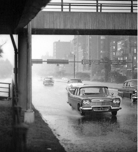
This 1959 photo shows Storrow Drive looking east toward the Copley Square (Clarendon Street) exit. (Photo from the Nick DeWolf photo archive [www.nickdw.com]; maintained by Steve Lundeen at Flickr.) |
||
|
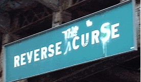
This 2003 photo shows the "Reverse Curve" sign mounted from the Longfellow Bridge that warned westbound Storrow Drive motorists of a "reverse curve" ahead, but over the years was altered by graffiti taggers to read "Reverse the Curse." This referred to the "Curse of the Bambino" and the World Series drought for the Boston Red Sox following Babe Ruth's trade to the New York Yankees in the 1919-1920 off-season. When the "curse" was lifted after the Red Sox won the World Series in 2004, Governor Mitt Romney altered the sign in a ceremony to read, "Reversed the Curse." The sign has since been removed. (Photo by Steve Alpert, www.alpsroads.net.) |
||
|
BUILDING THE RIVERFRONT PARKWAY: Construction of what was then known as "Embankment Road" began on October 10, 1949, as workers removed trees and relocated an eight-foot-wide sewer line to the planned alignment of the parkway. The parkway, which had a speed limit of 35 MPH, was built with the following lane configurations: |
||
|
The first section of the parkway, which now had the "Storrow Drive" designation over the objection of the late Helen Storrow, was opened to traffic in November 1950. The initial segment covered the western two-thirds of the route from Soldiers Field Road east to Dartmouth Street, where temporary entrance and exit ramps were built. A three-block long extension was opened east to the Copley Square interchange at Beacon Street in January 1951. On June 15, 1951, when Governor Paul Dever held an official ribbon-cutting ceremony, most of Storrow Drive had been completed, except for two sections: a tunnel under the Copley Square interchange for eastbound traffic, and ramps connecting to and from the Charles Circle interchange. This work was completed in November 1952. By the time Storrow Drive had been completed in its entirety to Leverett Circle, it already had reached its 1970 design capacity. POST-COMPLETION IMPROVEMENTS: Following completion of Storrow Drive, additional projects included the Arthur Fiedler Footbridge, a curved girder footbridge completed in 1953 that was dedicated to the longtime conductor of the Boston Pops, whose concerts took place along the Esplanade. At the eastern end of Storrow Drive, a twin-tube tunnel connecting the Leverett Circle to the John F. Fitzgerald Expressway / Central Artery (I-93) opened in 1954, coinciding with the completion of the Central Artery and the nearby High Bridge. Including improvements, the cost of Storrow Drive had doubled to $16 million. An elaborate interchange with the Charlesgate had been planned for Storrow Drive since it opened in 1952. This plan also called for the construction of a half-mile-long overpass connecting Storrow Drive over Charlesgate Park and the Boston and Albany Railroad right-of-way to Boylston Street and the Fenway. This connecting highway was delayed for more than a decade due to increased costs related to construction of the original Storrow Drive, residual steel shortages following the Korean War, and a lack of coordination between the MDC and the Massachusetts Turnpike Authority, which planned to build its extension from Weston (the 1957 terminus of the Mass Pike / I-90) east into downtown Boston along the Boston and Albany Railroad right-of-way. With work underway on the Massachusetts Turnpike extension, the MDC approved a revised plan for the Charlesgate overpass, which included accommodation for the Mass Pike right-of-way and a partial interchange at Commonwealth Avenue (northbound exit, southbound entrance). Construction of the connecting highway, which was renamed the Bowker Overpass after the former MDC Commissioner, began in 1963, and was completed on December 17, 1965. Importantly, the Bowker Overpass was completed one year before Section 4(f) of the Federal Highway Act, which placed severe restrictions on highway construction through parkland, became law. NOT AN APRIL FOOL'S JOKE: On April 1, 1960, a soup-like mixture of cement and construction aggregate burst through the road surface on Storrow Drive near the Boston University Bridge, creating geysers shooting nine feet into the air. The geysers, which closed portions of Storrow Drive and Soldiers Field Road for nearly a week, resulted from construction work to build a new $6 million sewer line some 15 feet below the roadway surface. Subsequent excavation work found wood pilings and granite blocks from the old Cottage Farm Bridge, which was demolished after the completion of the Boston University Bridge in 1928, and even old cider jugs. |
||
|
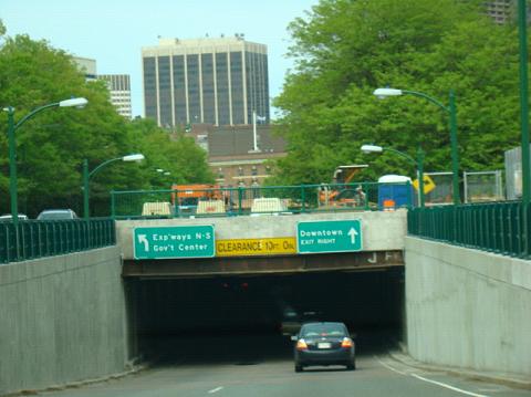
This 2009 photo shows the eastbound Storrow Drive approaching the Copley Square tunnel. Traffic bound for Copley Square exits right, while through traffic bound for Leverett Circle and the Central Artery (I-93) stays to the left. (Photo by David Golub, www.eastcoastroads.com.) |
||


|
FORMER ROUTE DESIGNATIONS: As Storrow Drive opened, Routes C-1 and C-9 were diverted from city streets onto the new parkway. The state signed Route C-1 and Route C-9 as alternate routes through the city of Boston, though maintenance of those routes were assigned to other jurisdictions. In this case, the MDC maintained jurisdiction over Routes C-1 and C-9. |
||

|
The Massachusetts Department of Public Works (MassDPW) removed the C-1 and C-9 designations in 1971, replacing them with the US 1 designation. In 1989, the MassDPW removed the US 1 designation from all MDC roadways, including Storrow Drive, the VFW Parkway, and the Jamaicaway, as none of these roadways were open to commercial traffic. The US 1 designation was shifted thereafter onto I-93 from Dedham north to Charlestown. |
||
|
PLANNED IMPROVEMENTS: Since 2003, the Massachusetts Department of Conservation and Recreation (DCR), which was formed through the merger of the MDC and the state's Department of Environmental Management, has had jurisdiction over Storrow Drive. The two exceptions to the DCR's jurisdiction are the eastbound tunnel under the Copley Square interchange, and the Bowker Overpass leading from the Charlesgate / Kenmore Square interchange, both of which are under the jurisdiction of the Massachusetts Department of Transportation (MassDOT). According to the DCR and MassDOT, Storrow Drive carries about 130,000 vehicles per day (AADT). |
||
|
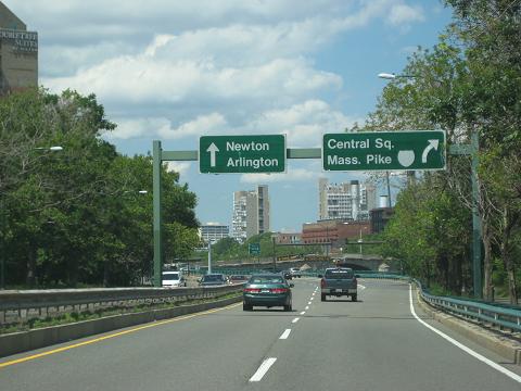
This 2015 photo shows the westbound Storrow Drive at the exit for Cambridge Street (Central Square / Mass Pike). Storrow Drive continues west as Soldiers Field Road. (Photo by Steve Anderson.) |
||

|
SOURCES: "Plan Outlined To Aid Traffic," The Boston Globe (11/24/1936); "Plan Eight Boston Speed Highways," The Boston Globe (2/15/1948); "Legislative Body Oks $6,200,000 Boston Parkway," The Boston Globe (3/23/1948); "New Charles River Embankment Road Killed in Senate," The Boston Globe (5/25/1948); Master Highway Plan for the Boston Metropolitan Area, Massachusetts Department of Public Works (1948); "Start of Many Master Plan Highways in 1950 Forecast," The Boston Globe (3/04/1949); "Embankment Road Approved by House in Stormy Session" by Samuel Cutler, The Boston Globe (4/29/1949); "Will Embankment Road Ease Downtown Traffic?" by Gene R. Casey, The Boston Globe (5/01/1949); "Tearing Up of Esplanade Begun for New Highway," The Boston Globe (10/11/1949); "Completed Section of Storrow Drive To Open Friday," The Boston Globe (10/31/1950); "Embankment Road Work Recalls Filling of Back Bay 95 Years Ago" by Stanley Howard, The Boston Globe (11/04/1950); "Embankment Road Opens One Way to Beacon at Noon," The Boston Globe (1/17/1951); "Embankment Road Opens Tomorrow to Two-Way Traffic," The Boston Globe (6/14/1951); "First Steps in Breaking the Charles Street Bottleneck for 50,000 Autos" by K.S. Bartlett, The Boston Globe (11/16/1952); "Storrow's Geysers Plugged--Temporarily" by A.S. Plotkin, The Boston Globe (4/06/1960); Gaining Ground: A History of Landmaking in Boston" by Nancy S. Seasholes, MIT Press (2003); "State Narrows Options on Crumbling Storrow Drive Tunnel" by Mac Daniel, The Boston Globe (6/21/2007); "Storrow Tunnel May Need Replacing" by Michael Levenson, The Boston Globe (7/24/2007); "Revived Plan for Detour on Esplanade Stirs Outrage" by David Abel, The Boston Globe (8/16/2007); "The Parkway Known As Storrow Drive" by David Boeri, The Boston Globe (7/17/2009); Charles River Esplanade Study Report, Boston Landmarks Commission-City of Boston (2009); "Pothole Renews Debate on Overpass" by Eric Moskowitz, The Boston Globe (3/12/2011); "Storrow Drive Tunnel To Close Weekday Nights" by Martine Powers, The Boston Globe (10/08/2012); "Charlesgate: Palimpsest of Urban Planning" by Allan Lasser, New Errands: The Undergraduate Journal of American Studies (Fall 2013); "The Evolution of Storrow Drive" by Dialynn Dwyer, The Boston Globe (7/29/2015); "New Pedestrian Bridge Begins To Swoop Across Storrow Drive," Universal Hub (10/28/2017); "Footbridge Over Storrow Drive Remains Unfinished Ahead of July 4 Festivities," WBZ-TV (7/03/2018); Esplanade Association; Massachusetts Department of Conservation and Recreation; Massachusetts Department of Transportation; George Sanborn. |
||
|
STORROW DRIVE LINKS: |
||
|
STORROW DRIVE CURRENT TRAFFIC CONDITIONS: |
||
|
STORROW DRIVE VIDEO LINKS: |
||

|
THE EXITS OF METRO BOSTON: |
||
|
Back to The Roads of Metro Boston home page. |
||
|
Site contents © by Eastern Roads. This is not an official site run by a government agency. Recommendations provided on this site are strictly those of the author and contributors, not of any government or corporate entity. |
||