Aerial view of the I-95 / MA 128 modified cloverleaf interchange in Canton. Note the abandoned carriageways extending north of the interchange that would have taken the Southwest Expressway (I-95) north into the city of Boston. (Photo by John D. Evans, Massachusetts Institute of Technology.)
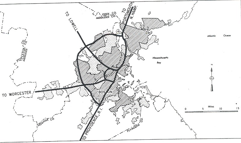
AN EXPRESSWAY FOR THE SOUTHWEST CORRIDR: In 1948, William F. Callahan, commissioner of the Massachusetts Department of Public Works (MassDPW), released for Master Highway Plan for Metropolitan Boston, which was to provide a blueprint for highway construction in the Boston area over the next 25 years. One of the radial expressways was to serve the Southwest Corridor along an old railroad right-of-way from Roxbury south to Route 128 at the current I-95 / I-93 interchange in Dedham.
The Southwest Expressway was to connect the urban core of Boston with the southwest suburbs, and eventually extend to Providence. It was to provide a continuous express route for both cars and commercial vehicles through an area where no continuous route existed before.
The Master Highway Plan further stated the route of the Southwest Expressway as follows:
Two very heavy desire lines of travel begin at the business district of Boston and extend to the southwest through Roxbury, Dorchester and Hyde Park sections of Boston, and through the towns of Milton and Dedham. US 1 from Providence, MA 138 (MA 24) from Taunton and Fall River, and MA 28 from Brockton and New Bedford contribute considerable traffic to this area. Traffic volumes appear to be insufficient to require the development of two expressways, and therefore the selection of a route was based upon finding a location that would lie generally between these two desire lines, serve the entire southwest area and not parallel existing usable arteries.
Washington Street and Blue Hill Avenue serve the majority of truck traffic through this area, while a large portion of the pleasure car traffic uses the Veterans of Foreign Wars Parkway (former US 1). It was felt that a new location should be developed between these two highways, to which existing thoroughfares could be connected to attract traffic to the new route. Because of the heavy concentration of population within the entire area traversed, selection of a suitable route was difficult. However, by studying a number of locations one was found where, by utilizing existing highways and vacant areas, and by traversing sections where property values were lowest, it was possible to find a route that could be developed at a reasonable cost.
THE ORIGINAL ALIGNMENT: The 10.3-mile-long Southwest Expressway was to begin at an interchange with the Southeast Expressway (I-93, US 1, and MA 3) and the Inner Belt (unbuilt I-695), in the vicinity of Massachusetts Avenue and Southampton Street in Roxbury. The six-lane expressway was to be extended along Blue Hill Avenue through Roxbury, and along the eastern edge of Franklin Park in Dorchester. Continuing south of Franklin Park to Cummings Highway in Hyde Park, the entire length of the American Legion Parkway was to be converted to expressway standards. Just south of Cummings Highway, a 1.1-mile-long, four-lane spur was to connect to Neponset River Parkway, while the mainline expressway (now reduced to four lanes) was to continue south, following the New York, New Haven and Hartford Railroad right-of-way through vacant land. About two and one-half miles to the south, the expressway was to terminate at US 1 in Dedham.
Interchanges were to have been built at the following locations:
Southeast Expressway (I-93) / Inner Belt (unbuilt I-695), Roxbury Massachusetts Avenue, Roxbury Seaver Street (MA 28) / Blue Hill Avenue, Dorchester Cummings Highway, Hyde Park Neponset River Parkway, Hyde Park Gordon Avenue, Hyde Park Milton Street (MA 135), Dedham East Street, Dedham Yankee Circumferential Highway (MA 128), Dedham US 1, Dedham
DESIGN CONVENTIONS: The Southwest Expressway was to adhere to the design conventions recommended in the 1948 Master Highway Plan: six 12-foot-lanes separated by a variable median, 12-foot-wide emergency shoulders and flanking service roads within a 300-foot-wide right-of-way. However, along the depressed sections in more heavily urbanized areas, the six-lane expressway was to be constructed within a 170-foot-wide right-of-way. South of the Neponset River Parkway connection in Milton, the expressway was to narrow to four lanes, but maintain a 300-foot-wide right-of-way.
The expressway, which had a design speed of 50 MPH, was designed to handle approximately 45,000 vehicles per day (AADT) along the six-lane section, and approximately 25,000 vehicles per day along the four-lane section. More specific, Interstate-compatible design recommendations called for 16-foot bridge clearances (this was higher than the 14½-foot standard because of the route's significance as a defense route) and continuous shoulders on viaducts.
To avoid physical obstructions and minimize community disruption, planners incorporated a number of curves into the route. However, the general alignment of the entire Southwest Expressway varied only slightly from a straight line.
This artist's conception from 1965 shows the terminus of the Southwest Expressway (I-95) at the Inner Belt Expressway (I-695) in the Roxbury neighborhood of Boston. (Figure by Massachusetts Department of Public Works.)
PART OF THE INTERSTATE NETWORK: From the beginning, the MassDPW included the Southwest Expressway as part of the proposed Interstate highway network. In 1955, the Federal Bureau of Public Roads (BPR) included the Inner Belt as part of the preliminary national network, ensuring that the MassDPW would be reimbursed for 90 percent of the $24 million cost. The route was to be part of I-95, which was originally planned to run 78 miles through the commonwealth.
CHANGES IN ALIGNMENT AND SCOPE: In 1962, the MassDPW released a comprehensive report on the Inner Belt and connecting radial routes, including the Southwest Expressway. The report, which was submitted to the BPR, included the following changes to the route:
The length of the Southwest Expressway had been shorted to 10.0 miles. Beginning at a "semi-directional T" interchange with the Inner Belt Expressway (I-695) in the vicinity of Columbus Avenue (MA 28) and Ruggles Street in Roxbury, the Southwest Expressway was to run parallel to the New York, New Haven and Hartford (Penn Central) Railroad right-of-way through Jamaica Plain and Forest Hills. At Hyde Park, the alignment was to veer east of the railroad right-of-way, and cross Fowl Meadows Reservation before terminating at Yankee Division Highway (MA 128). I-95 (which was under construction south of MA 128 at the time) was to continue to Providence and points south.
The expressway was to be constructed within a wider 400-foot right-of-way. This right-of-way was to accommodate four 12-foot-wide lanes in each direction, 12-foot-wide inner and outer shoulders in each direction, flanking service roads, landscaped areas between the expressway and service roads, and a 50-foot-wide median to accommodate two MBTA-Orange Line tracks. The eight-lane expressway was designed to handle approximately 200,000 vehicles per day (AADT). (A subsequent 1968 MassDPW report recommended an extension of the Orange Line along the Southwest Expressway corridor to MA 128.)
The MassDPW also contemplated a possible northern extension of the Southwest Expressway along Columbus Avenue. The "South End Bypass," which was to have connected the I-95 / I-695 interchange in Roxbury with the Massachusetts Turnpike (I-90), did not have a route designation.
The MassDPW reiterated its support for the Southwest Expressway as follows:
There are no adequate existing major thoroughfares connecting the inner core of Boston with Route 128 in the Southwest Corridor. All streets and thoroughfares that serve this quadrant of the Boston metropolitan area have either one of the following two limitations:
Narrow, two-lane, heavily congested streets (such as Washington Avenue and Hyde Park Avenue) serve mainly high-density residential and commercial areas.
Major four-lane thoroughfares (such as the VFW Parkway, the Jamaica Way and Blue Hill Avenue) do not offer a continuous route into Boston, and pass through points of heavy traffic congestion and high-density commercial development.
The main line of the New York, New Haven and Hartford Railroad extends in a direct line between the Inner Belt and Route 128, and occupies the most favorable connecting natural or topographic avenue. The area on each side of the railroad contains many hills, abrupt changes in elevation, ledge outcroppings and other difficult topographic features that have an important bearing on construction costs, and consequently, on location selection.
The new Southwest Expressway was scheduled for completion in 1969. By the late 1960's, spiraling construction and right-of-way expenditures sent the cost of the expressway from $24 million (the original 1948 cost) to $159 million. Its completion date had been pushed back to 1975. At one point, tolls were even proposed as a means of financing the Southwest Expressway.
A NEW URBAN PARADIGM: This 1970 model shows the proposed Southwest Expressway (I-95) through the Roxbury-Forest Hills corridor. A 50-foot-wide median was to be reserved for two MBTA-Orange Line rapid transit tracks. Air rights over the expressway were to be used for residential areas and parks. (Photo by Massachusetts Department of Public Works.)
THE FIGHT OVER THE SOUTHWEST CORRIDOR BEGINS: The early experiences with the elevated Central Artery (I-93, earlier designated I-95) through downtown Boston compelled community activists to fight the Inner Belt Expressway (I-695) through much of the 1960's. By the end of the decade, these forces moved their fight to the Southwest Expressway, where construction crews had torn down residential units along the right-of-way in Roxbury and Jamaica Plain. It was already apparent that the expressway that create a "Chinese Wall" through well-established communities in the South End. The neighborhood of Hyde Park, where demolition had not yet taken place, even threatened to secede from the city of Boston over the Southwest Expressway issue.
In an early attempt to address community concerns, the MassDPW devised an engineering solution. The depressed ten-foot profile (that is, ten feet below street level) was to "offer communities the advantage of better pollution protection" while presenting "realistic opportunities for the communities to span the corridor with air rights developments that are independent of roadway construction." Industrial and commercial developments were proposed at highway access points, while the areas between access points (where the air rights developments were to be placed) were to provide continuity of residential zones and provide new housing. Stations for the relocated MBTA-Orange Line were to be located "in response to community needs." Nevertheless, community activists remained skeptical of MassDPW plans for the Southwest Corridor.
LEFT: This 2001 photo shows an abandoned ramp at the I-95 / MA 128 / I-93 interchange in Canton. RIGHT: This 2001 photo shows the abandoned northbound lanes of the Southwest Expressway (I-95) just north of MA 128 in Canton. (Photos by Dan Moraseski.)
BALANCING CONCERNS OF ROADS, RAILS AND COMMUNITIES: In February 1970, Governor Francis Sargent ordered a moratorium on all new expressway construction within MA 128 (Yankee Division Highway), and ordered a review of expressway and transit plans in the Boston area. From the governor's action, the Boston Transportation Planning Review (BTPR) was born.
Governor Sargent had the following early comments on the Southwest Corridor:
My new Balanced Transportation Development Program will embrace the Southwest Expressway corridor. The state now owns three-quarters of the land in that corridor. We are committed to use that corridor. Plans now call for massive highway construction there: an eight-lane highway, plus four extra breakdown lanes.
The old plan does call for rapid transit in the Southwest Corridor. However, it does not consider its proper integration, or other innovative transportation alternatives now available to us. Furthermore, it does not consider the impact on the environment, on land use, on housing and on people. I have decided that it must. My new program will be broad in scope and will consider all aspects of development of a transportation system in the corridor, for a new transportation line must be constructed there.
In the BTPR Phase II report, which was released in December 1971, Governor Sargent modified plans for the Southwest Corridor. Instead of the eight-lane expressway originally planned, the governor called for the construction of a six-lane expressway. Four of the lanes were to be for general use, while the two innermost lanes in each direction were to be reserved for HOV use.
Sargent maintained his steadfast desire for mass transit in the Southwest Corridor:
The Orange Line will be routed along the Penn Central (Amtrak) right-of-way from the South Cove Tunnel to Forest Hills, with extensions to West Roxbury and Needham, and to Route 128 in Canton. Right-of-way will also be reserved for high-speed ground transportation between Boston and New York City. Options for improved commuter rail service will also be investigated in this corridor.
Near the conclusion of BTPR studies in November 1972, Governor Sargent eliminated the entire Southwest Expressway (I-95) from further consideration, citing that no "feasible and prudent" alternative route could be constructed through the area. He explained his reasoning as follows:
Following my determination in December 1971 that no further effort be made to design expressways for the accommodation of peak-hour, general-purpose traffic demand, BTPR planners developed several plans for mini-expressways that were indeed far more appropriate to the transportation needs of the region than the larger expressways for whose re-examination I had called in 1970. If designed and managed so as to minimize disruption and competitiveness with the transit system, they could have provided some genuine benefits.
They were also extremely costly, however. It was found that the costs inevitably associated with these facilities would have exceeded their benefits. The costs I have in mind are not simply dollar costs, though these would have been extremely great. Even more significantly, I have borne in mind the impacts that construction of these facilities would have had upon the social, economic and environmental impact of the region.
The Southwest Expressway, for example, would have involved running an elevated highway through the Fowl Meadow Reservation, a major water resource, wildlife sanctuary and recreational open space facility. It would have also involved the further dislocation of about 370 families and 800 jobs. Finally, it would have involved overruling the clear preference of most elected officials and private citizens in the Southwest Corridor who have made their views known.
In 1973, the I-95 designation was rerouted along MA 128 (Yankee Division Highway), avoiding the city of Boston entirely. On May 23, 1974, the unbuilt I-95 and I-695 through Boston were among the first Interstates to be traded in for transit funds under the Federal Highway Act of 1973.
In 1977, the MassDPW converted the existing cloverleaf interchange at the I-95 / I-93 junction in Canton into a "trumpet" interchange. The southbound I-93 cloverleaf loop ramp to southbound I-95 was replaced with a two-lane "trumpet" ramp. In 1985, the MassDPW dismantled a section of the unused flyover ramp that was to carry traffic from the Southwest Expressway to MA 128 southbound (now I-93 northbound).
WHAT WOULD HAVE BEEN: This 2001 photo shows the overhead sign at the intersection of MA 28 (Blue Hills Parkway), MA 138 (Blue Hill Avenue) and Truman Highway in Milton )(Mattapan), just over the Neponset River from Boston (Hyde Park). The sign on the right was to read "READVILLE-- TO I-95 DEDHAM." (Photo by Dan Moraseski.)
NEW LIFE FOR THE SOUTHWEST CORRIDOR: The 1972 BTPR study that recommended scrapping the Southwest Expressway cleared the way for a groundbreaking transit, commuter rail and parks project. Planning for the Southwest Corridor project included over 1,000 meetings with communities along the corridor to discuss everything from station location and design to flow of related automobile traffic, construction materials, landscaping materials, installation of station art, and use of adjacent parkland. After seven years of planning, the Massachusetts Bay Transportation Authority (MBTA) began construction of the project in 1979.
The 4.7-mile-long project, which replaced the existing Amtrak-MBTA commuter rail tracks and the nearby Washington Street elevated transit line, entailed construction of tunnels for the MBTA-Orange Line, the MBTA-Providence commuter rail line and the Amtrak-Northeast Corridor line. Designed to serve up to one-quarter of Boston's population, the Southwest Corridor project also included the construction of nine new Orange Line stations and the creation of a 52-acre linear park.
After eight years of construction, the tunnels opened to rail traffic on May 4, 1987. At a cost of $743 million, the Southwest Corridor project was at that time the largest construction project in state history. In 1988, the project won the "Outstanding Civil Engineering Achievement" award from the American Society of Civil Engineers (ASCE).
SOURCES: Master Highway Plan for the Boston Metropolitan Area, Massachusetts Department of Public Works (1948); "A Report of Progress," Massachusetts Department of Public Works (1962); "Inner Belt and Expressway System," Massachusetts Department of Public Works (1962); "Boston Regional Survey: Highways," Mass Transportation Commission, Commonwealth of Massachusetts (1962); "Boston Inner Belt Expressway," Massachusetts Department of Public Works (1965); Recommended Highway and Transit Plan, Massachusetts Department of Public Works (1968); "The Massachusetts Highway Story," Massachusetts Department of Public Works (1969); "Drive in Boston May Bring a New Urban Transit Mix" by Bill Kovach, The New York Times (7/24/1970); "Southwest Corridor Study," Massachusetts Department of Public Works (1970); "Southwest Expressway," Massachusetts Department of Public Works (1971); Rites of Way: The Politics of Transportation in Boston and the U.S. City by Alan Lupo, Frank Colcord and Edmund P. Fowler, Little, Brown and Company (1971); "Mass Transit Plan for Massachusetts" by Bill Kovach, The New York Times (11/30/1972); Boston Transportation Planning Review: Final Study Summary Report, Massachusetts Department of Public Works (1972); "Boston's Southwest Corridor: How an Interstate Gave Way to a Linear Park," Urban Parks Online (April 1997); "Washington Street: The Struggle for Equity in Transit Planning" by John Kyper, The Massachusetts Sierran (June 1998); Massachusetts Bay Transportation Authority; John Cairns; Daniel DeAmicis; Neil Kelly; Dan Moraseski; Scott Moore; Ron Newman; Fred Salvucci; George Sanborn; Paul Schlichtman; Garrett Wollman.
I-95 shield by Ralph Herman. Lightpost by Millerbernd Manufacturing Company. HOV sign by C.C. Slater.


