
|
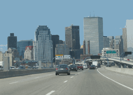
This 2006 photo shows the northbound Southeast Expressway (I-93) at the rebuilt EXIT 20 (I-90 / Massachusetts Turnpike) in Boston. At this point, I-93 transitions to the John F. Fitzgerald Expressway / Central Artery. (Photo by Steve Anderson.) |
||

|
FROM DOWNTOWN BOSTON TO THE SOUTH SHORE: In 1948, William F. Callahan, commissioner of the Massachusetts Department of Public Works (MassDPW), proposed a controlled-access route to link downtown Boston with towns and cities along the South Shore. The Southeast Expressway was to not only provide commuter access to the South Shore, but also facilitate traffic movements headed to and from Cape Cod. |
||
|
The 1948 Master Highway Plan for the Boston Metropolitan Area described the Southeast Expressway as follows: |
||
|
Interchanges were to be built at the following locations: |
||
|
Another interchange may have been proposed with the Yankee Circumferential Highway (MA 128); however, no specific location was provided in the 1948 Master Highway Plan. |
||
|
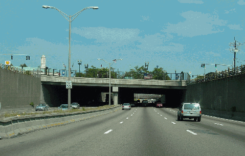
This 2003 photo shows the northbound Southeast Expressway (I-93, US 1, and MA 3) at the Adams Street underpass in Milton. (Photo by Jim K. Georges.) |
||
|
DESIGN AND CONSTRUCTION: For the most part, the Southeast Expressway adhered to the design conventions recommended in the 1948 Master Highway Plan: six 12-foot-lanes separated by a variable median, 12-foot-wide emergency shoulders and flanking service roads within a 300-foot-wide right-of-way. Most of the route was to be constructed on embankments of varying height to keep the grade line well above the frequent high tides. However, along the depressed sections through Quincy, the six-lane expressway was to be constructed within a 170-foot-wide right-of-way. |
||
|
The original expressway design called for creating a parkway-like atmosphere, complete with lush landscaping and stone-arch overpasses. When the expressway was constructed, however, the MassDPW constructed conventional steel-girder and concrete overpasses. Moreover, a fixed-level bridge - not a moveable bridge - was built over the Neponset River. |
||
|
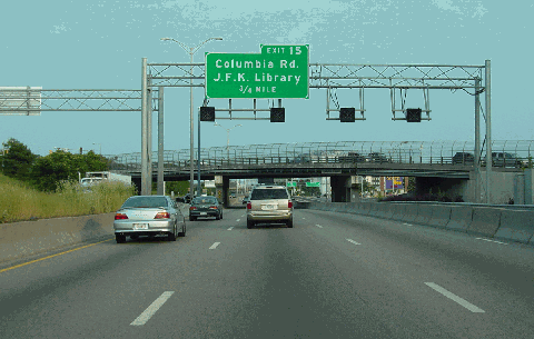
This 2003 photo shows the southbound Southeast Expressway (I-93, US 1, and MA 3) approaching EXIT 15 (Columbia Road) near the Uphams Corner neighborhood of Boston. (Photo by Jim K. Georges.) |
||
|
CHANGES IN DESIGNATION: Originally opened as part of MA 3, the Southeast Expressway added the extended I-93 designation in the early 1970's upon the recommendation of the Boston Transportation Planning Review (BTPR). The BTPR advocated the cancellation of the Southwest Expressway (I-95) through Canton-Milton-Boston, and suggested the Southeast Expressway as a substitute Interstate corridor. In 1989, the Southeast Expressway added the (relocated) US 1 designation. |
||
|
RELIEF AND RECONSTRUCTION: As early as 1968, transportation planners considered a variety of improvements along the Southeast Expressway corridor to relieve congestion. Citing the impracticality of upgrading existing routes such as MA 3A (Hancock Street) and Morrissey Boulevard to provide a continuous, high-standard arterial route, the MassDPW suggested providing additional expressway lanes, and reconstructing entrance and exit ramps (which would be metered to control access). |
||
|
In 1971, with traffic volumes exceeding 110,000 vehicles per day, the MassDPW tested exclusive bus lanes (XBL) along the left lanes of the Southeast Expressway during the morning and evening peak travel periods. The two-month trial of the XBL lanes, in which the six-lane expressway was reconfigured 4-2 (northbound-southbound) during the morning rush and 4-2 (southbound-northbound) during the afternoon rush, met with mixed reviews. Traffic cones separated the exclusive bus lanes from opposing flows, raising safety concerns. |
||

|
The XBL lanes, another recommendation from the ambitious BTPR project of the early 1970's, were to be implemented on a permanent basis in place of the canceled Southwest Expressway (I-95). Specifically, the BTPR made the following recommendation: |
||
|
In 1995, after one year of construction, the Massachusetts Highway Department (MHD) completed the construction of a six-mile-long reversible HOV lane. The HOV lane is separated from the regular travel lanes by moveable concrete barriers. Before the morning rush, two computer-controlled transfer machines move 12 miles of concrete barrier (weighing a total of 28,500 tons) a distance of 14 feet across the roadway to create an additional lane in the northbound direction. The process is reversed in the southbound direction for the evening rush. When it opened, the reversible HOV lane was reserved for buses, motorcycles and vehicles with three or more occupants. The restriction has since been loosened to vehicles with two or more occupants. |
||

|
The Southeast Expressway corridor received additional relief with the MHD conversion of the existing emergency shoulders as travel lanes from the Neponset River Bridge south to EXIT 7 (MA 3 / Pilgrims Highway). The use of the shoulders, which is permitted only during the morning and afternoon peak travel periods, has come under criticism from transportation safety experts. |
||
|
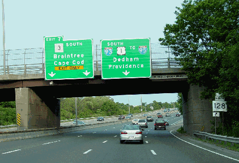
This 2003 photo shows the southbound Southeast Expressway (I-93, US 1, and MA 3) approaching the "Braintree Split" (EXIT 7 / MA 3-Pilgrims Highway). (Photo by Jim K. Georges.) |
||

|
SOURCES: Master Highway Plan for the Boston Metropolitan Area, Massachusetts Department of Public Works (1948); "A Report of Progress," Massachusetts Department of Public Works (1962); "Inner Belt and Expressway System," Massachusetts Department of Public Works (1962); Recommended Highway and Transit Plan, Massachusetts Department of Public Works (1968); "The Massachusetts Highway Story," Massachusetts Department of Public Works (1969); "Rush Hour Lanes for Buses Are Tested on Expressway on Boston," The New York Times (7/11/1971); Boston Transportation Planning Review: Final Study Summary Report, Massachusetts Department of Public Works (1972); "Southeast Expressway: Corridor Transportation Management for Highway Reconstruction," Federal Highway Administration and Massachusetts Department of Public Works (1986); "Highway Needs Cause Safety Breakdown" by Mac Daniel, The Boston Globe (2/10/2002); Barrier Systems, Incorporated; Massachusetts Highway Department; Dan Moraseski; Scott Moore; George Sanborn; Paul Schlichtman; Alexander Svirsky; Yanni Tsipis. |
||


|
SOUTHEAST EXPRESSWAY LINKS: |
||
|
SOUTHEAST EXPRESSWAY CURRENT CONDITIONS: |
||

|
THE EXITS OF METRO BOSTON: |
||
|
VIEW OR SUBMIT YOUR RATING TO RATETHEROADS.COM: |
||
|
|
||

|
Back to The Roads of Metro Boston home page. |
||
|
Site contents © by Eastern Roads. This is not an official site run by a government agency. Recommendations provided on this site are strictly those of the author and contributors, not of any government or corporate entity. |
||