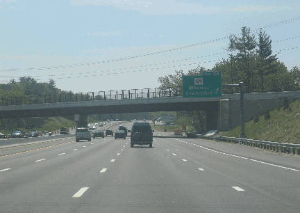
This 2005 photo shows the southbound Northwest Expressway (US 3) approaching EXIT 29 (MA 29 / Billerica Road) in Billerica. The completion of the widening project in October 2004 provided three travel lanes in each direction. (Photo by Steve Anderson.)
THE CHELMSFORD BYPASS: The first section of the Northwest Expressway opened in 1941 as a bypass of the existing US 3 through the urbanized Chelmsford area. Stretching approximately four miles from EXIT 29 (MA 129 / Billerica Road) north to EXIT 32 (MA 4 / North Road), the four-lane highway is characterized by its narrow median, and by its steel-beam bridges with iron railings. At the northern terminus of the initial section in Drum Hill - where the Drum Hill Rotary exists today - the expressway ended at an at-grade intersection.
The onset of World War II delayed further construction of the Northwest Expressway. Once the war ended, officials at the Massachusetts Department of Public Works (MassDPW) devised a plan to extend the Northwest Expressway into Cambridge, where it was to terminate at the Inner Belt Expressway (I-695). At the same time, state officials submitted the proposed route of the Northwest Expressway (US 3) to the Federal Bureau of Public Roads (BPR) as the Interstate highway corridor connecting Massachusetts and New Hampshire. However, the BPR ultimately selected the Northern Expressway (I-93) just a few miles to the east as the Interstate corridor.
In the early 1960's, a new EXIT 30 was constructed to connect US 3 to I-495 (Outer Circumferential Highway) and the Lowell Connector.
SOUTH TO ROUTE 128: While towns in inner-ring suburbs such as Lexington and Arlington fought the extension of US 3, plans were already in the works for a nine-mile-long extension of the Northwest Expressway from Chelmsford south to MA 128 (Yankee Division Highway) in Burlington. The area was mostly rural at the time, but traffic counts along Middlesex Turnpike (MA 3A) were steadily growing, and development along the old road necessitated construction of a controlled-access route along a new right-of-way. After three years of construction, the southern extension to Burlington was opened to traffic in 1955.
The Burlington-to-Chelmsford section was characterized by its straight alignment and its wide wooded median. While expressway bridges were a mix of steel-beam and arched-concrete designs, all bridge abutments had a cut-stone design. At EXIT 25, the southern terminus of the Northwest Expressway, a cloverleaf interchange was built between US 3 and MA 128 to accommodate a future extension of US 3 to Cambridge.
NORTH TO WESTFORD: From 1957 to 1960, the Northwest Expressway was extended approximately four and one-half miles north to EXIT 34 (Westford Road). This section of rural four-lane expressway, which followed the MassDPW highway design tenets of the late 1950's, marked a return to wide medians.
The existing EXIT 32 (MA 4 / North Road) was reconstructed to incorporate a rotary between the exit ramps, MA 4, Drum Hill Road and Old Westford Road; bridges separated the rotary from the main roadways of the US 3 Expressway. Such an interchange setup was common construction in Massachusetts during the 1950's and 1960's.
THE MISSING LINK IN TYNGSBORO: With the 1960 completion of 17.5 miles of expressway from Burlington north to Westford, and the completion of the F.E. Everett Turnpike in New Hampshire a couple of years earlier, a gap of approximately three and one-half miles remained. After two years of construction, the MassDPW filled in this four-lane missing link through Tyngsboro in 1967, completing the US 3 Expressway through Massachusetts.
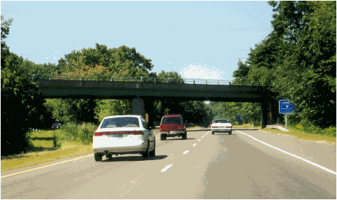
This 2000 photo shows the northbound Northwest Expressway (US 3) approaching EXIT 26 (MA 62 / Burlington Road) in Bedford. This photo was taken ten months prior to the start of reconstruction. (Photo by Steve Anderson.)
REBUILDING AND WIDENING ROUTE 3: According to the Massachusetts Highway Department (MHD), the Northwest Expressway - known locally as "Route 3 North" - carries approximately 85,000 vehicles per day (AADT) from I-95 / MA 128 north to I-495, and approximately 70,000 vehicles per day (AADT) from I-495 north to the Massachusetts-New Hampshire border.
As early as 1968, the MassDPW anticipated the need to widen the Northwest Expressway, but made no specific short-term recommendations. Two years later, the Massachusetts Legislature directed the MassDPW to widen the existing US 3, but the department did not take any action. At the time, the widening of US 3 was predicated on the eventual extension of the expressway into Cambridge and Boston.
By the early 1990's, predictions of chronic congestion along US 3 had been fulfilled, and soon the MHD and the Federal Highway Administration (FHWA) conducted studies on widening the existing expressway to six lanes along the entire 21-mile-long route. State and Federal officials approved final plans for the expansion project in 1998.
The Northwest Expressway reconstruction project, which began in April 2001, was divided into three sections, and consisted of the following activities:
At the earliest stage of construction, earthwork was done in areas where trees needed to be cleared, and blasting was done in rocky areas.
The existing four-lane highway was widened to include six travel lanes (three in each direction) and new emergency shoulders. Along the southern and northern sections, the new lanes were built in the wide center median. Along the central (limited-median) section, the new lanes are being constructed along an expanded right-of-way.
Along the length of the route, 47 bridge structures were replaced completely.
The 13 interchanges along the route were upgraded, and feature rebuilt ramps and improved acceleration-deceleration lanes. (In particular, EXITS 30 A-B-C, which provides access to I-495 and the Lowell Connector, was significantly reconstructed.) Moreover, 17 new traffic signals were installed along the corridor.
Variable message signs were installed to manage traffic during and after the project.
Environmental resources such as wooded areas and wetlands were protected through the construction of a new drainage system, as well as through the use of silt fences and hay bales.
Originally scheduled for full completion by February 2004, the $385 million reconstruction project was substantially finished in October 2004 with the completion of the widening. Landscaping and other minor work were completed in late 2005. The contractor for the project, Modern Continental, was fined the maximum $3.8 million for late completion of the project.
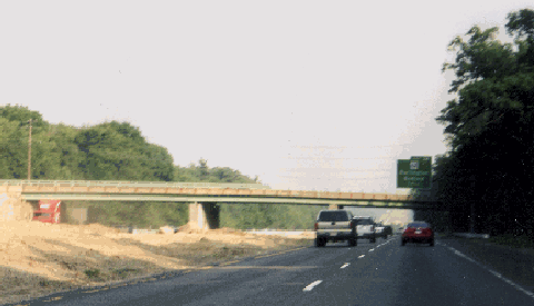
This 2001 photo shows the southbound Northwest Expressway (US 3) approaching EXIT 26 (MA 62 / Burlington Road) in Bedford. Note the median being prepared for one additional travel lane in each direction. (Photo by Steve Anderson.)
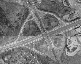
Aerial view of the interchange between the Northwest Expressway (US 3) and the Yankee Division Highway (I-95 and MA 128) in Burlington. Originally constructed as a full cloverleaf interchange to accommodate a future extension of US 3, the cloverleaf was converted into a trumpet interchange. (Photo by John D. Evans, Massachusetts Institute of Technology.)
AN EXPRESSWAY FOR THE NORTHWEST CORRIDOR: In 1948, the MassDPW released the Master Highway Plan for Metropolitan Boston, a report that was to provide a blueprint for highway construction in the Boston area over the next 25 years. The Northwest Expressway was to connect the urban core of Boston with the northwest suburbs, and continue northwest along an expressway corridor already under development via the Lowell-Chelmsford area to southern New Hampshire.
The Master Highway Plan stated the purpose of the Northwest Expressway as follows:
There is a very heavy travel trend to the northwest through Somerville and Arlington to the Concord Turnpike (MA 2), and to the north via Medford, Winchester and Woburn. This section of the metropolitan area is very heavily populated, and at the present time is not served adequately by any highways connecting directly with downtown Boston.
It is therefore mandatory to provide a direct expressway connection between downtown Boston and the cities and towns to the northwest in order to remedy this situation. In developing this expressway, many alternate studies were made to find the best location that would coincide with the desire lines of travel, and at the same time serve traffic approaching the metropolitan area from the north and northwest via the Concord Turnpike, US 3 and MA 38.
THE ORIGINAL ALIGNMENT: From the Inner Belt Expressway (I-695) northwest to the Yankee Division Highway (MA 128), the 9.1-mile-long Northwest Expressway was originally routed through Cambridge, Arlington, Medford, Winchester and Woburn. Two spurs from the expressway were to connect to Concord Turnpike (MA 2) in Cambridge, and to MA 38 in Woburn. The six-lane section from the Inner Belt northwest to MA 2 was to carry approximately 65,000 vehicles per day (AADT), while the four-lane section north of MA 2 was to carry between 20,000 and 35,000 vehicles per day.
Interchanges were to be located at the following locations:
· Inner Belt Expressway (I-695), Cambridge · Washington Street, Cambridge · Porter Square, Cambridge · Rindge Avenue, Cambridge · Concord Turnpike Spur (MA 2), Cambridge · Massachusetts Avenue (MA 2A), Arlington · Pleasant Street (MA 60), Arlington · Bacon Street, Winchester · Lake Street, Winchester · Pond Street, Winchester · MA 38 Spur, Woburn
The original project - the 9.1-mile-long Northwest Expressway, the 1.0-mile-long MA 2 Spur and the 2.1-mile-long MA 38 Spur - was estimated to cost $13 million. Continuing north of MA 128, the Northwest Expressway was to follow the route of the "Relocated US 3" to Lowell and southern New Hampshire.
This 2005 photo shows the southern terminus of the Northwest Expressway (US 3) at EXIT 25 (I-95 / MA 128 / Yankee Division Highway) in Burlington. Plans to extend the expressway south to Cambridge were killed in the early 1970s. (Photo by Jim K. Georges.)
REVISIONS TO THE CORE HIGHWAY SYSTEM: In 1962, the MassDPW revised the proposed route of the Northwest Expressway to reflect the completed route of the US 3 Expressway south to Burlington, and to reflect updated plans for I-695 and the MA 2 Expressway. The revised plans for the Northwest Expressway were as follows:
Beginning at the Inner Belt Expressway (I-695) in the vicinity of Donnelly Field, the Northwest Expressway was to parallel the Boston and Maine Railroad for three miles through Cambridge. This section of eight-lane expressway, which was to carry the US 3 and MA 2 designations, was to relieve congested two-lane streets and four-lane arterials (most of which do not provide through service). Construction of the expressway was to be coincident with urban renewal efforts.
In the vicinity of Alewife Brook Parkway (on the Cambridge-Arlington border), the Western Expressway (MA 2) was to branch off the Northwest Expressway (US 3). North of this point, the Northwest Expressway was to narrow from eight to four lanes.
Through Arlington and Lexington, the four-lane expressway was to be routed roughly along Summer Street and Lowell Street. In the Arlington area, construction may have required considerable rock excavation. Through the "Great Meadows" of Lexington, fill may have been required to build the highway through wetlands.
The project limit is Burlington was marked by the partially completed cloverleaf interchange between the Northwest Expressway (US 3) and the Yankee Division Highway (MA 128 / I-95).
Completion of the expressway, whose cost had risen to $33 million, was scheduled for 1969. Although the MassDPW received authorization to construct the expressway, the state legislature did not allocate any funds for the route.
EXTENSION IN QUESTION: In its 1968 Recommended Highway and Transit Plan, the MassDPW began to reconsider its proposal to extend the US 3 Expressway south of MA 128 in Burlington. Forecasting an overloaded Northwest Expressway (US 3 and MA 2) through Cambridge due to the location of the US 3-MA 2 "T-interchange," the MassDPW recommended against extended the Northwest Expressway south to the Western Expressway (MA 2). Instead, the MassDPW advocated extending US 3 - perhaps along Mystic River Parkway - to the Northern Expressway (I-93) in Medford at a future date.
Two years later, in 1970, Governor Francis Sargent ordered a moratorium on all new expressway construction within MA 128 (Yankee Division Highway), and ordered a review of expressway and transit plans in the Boston area. From the governor's action, the Boston Transportation Planning Review (BTPR) was born. All of the expressways planned in the northwest sector - US 3, MA 2 and I-695 - ultimately were killed following the recommendations of a 1971 BTPR report.
In the early 1990's, two decades after the US 3 extension into Cambridge had been canceled, the state converted the existing cloverleaf interchange at EXIT 25 (I-95 / MA 128 /Yankee Division Highway) in Burlington into a "trumpet" interchange. The northbound I-95 / MA 128 loop ramp to northbound US 3 was replaced with a "trumpet" ramp.
MASS TRANSIT FOR THE NORTHWEST CORRIDOR: In place of the Northwest Expressway, the MBTA Red Line was extended northwest through Cambridge from Harvard Square to Alewife. After four years of construction, the Red Line extension was completed in 1985.
The exit numbering scheme should be reset at the existing southern terminus of the Northwest Expressway (US 3) in Burlington. The new exits should be numbered as follows (old exits in parentheses):
EXIT 1 (25): I-95 / MA 128 (Yankee Division Highway) EXIT 2 (26): MA 62 EXIT 3 (27): Concord Road EXIT 4 (28): Treble Cove Road EXIT 5 (29): MA 129 EXIT 6 (30): I-495 (Outer Circumferential Highway) and Lowell Connector EXIT 7 (31): MA 110 EXIT 8 (32): MA 4 (Drum Hill Rotary) EXIT 9 (33): MA 40 EXIT 10 (34): Westford Road EXIT 11 (35): MA 113 EXIT 12 (36): Middlesex Road
Given the completion of upgrades in recent years, the Northwest Expressway should be re-designated I-293 to denote its status as an alternate route to I-93. The I-293 designation would extend north into New Hampshire onto the Everett Turnpike, while the existing US 3 designation would revert to the existing MA 3A.
SOURCES: Master Highway Plan for the Boston Metropolitan Area, Massachusetts Department of Public Works (1948); "A Report of Progress," Massachusetts Department of Public Works (1962); "Inner Belt and Expressway System," Massachusetts Department of Public Works (1962); "Boston Regional Survey: Highways," Mass Transportation Commission, Commonwealth of Massachusetts (1962); Recommended Highway and Transit Plan, Massachusetts Department of Public Works (1968); "The Massachusetts Highway Story (1949-1969)," Massachusetts Department of Public Works (1969); Boston Transportation Planning Review: Final Study Summary Report, Massachusetts Department of Public Works (1972); "Highway Needs Cause Safety Breakdown" by Mac Daniel, The Boston Globe (2/10/2002); "Redesign, Traffic Signals To Ease Drum Hill Flow" by Caroline Louise Cole, The Boston Globe (5/12/2002); "Route 3 Project Deadline Penciled in for May" by Mac Daniel, The Boston Globe (1/11/2004); "Route 3 Done? Think Again" by Tom Spoth, The Lowell Sun (4/03/2005); Massachusetts Highway Department; Modern Continental Construction Company; URS Corporation; John Carr; Todd Glickman; Douglas Kerr; Dan Moraseski; George Sanborn; Paul Schlichtman; Alexander Svirsky.
US 3 shield by Ralph Herman. Lightposts by Millerbernd Manufacturing Company.


