This 2003 photo shows the southbound Northern Expressway (I-93) at EXIT 30 (MA 28-MA 38) in Medford. (Photo by Jim K. Georges.)
A BYPASS OF ROUTE 28: In 1948, the Massachusetts Department of Public Works (MassDPW) proposed an expressway bypass of MA 28 (Northern Artery and Fellsway). The Master Highway Plan for Metropolitan Boston outlined plans for a 12.5-mile-long, six-lane route stretching from downtown Boston to just north of the MA 128 (Yankee Division Highway) in Reading.
The Master Highway Plan outlined the route of the Northern Expressway as follows:
Traffic from north to south through the north central section of the metropolitan area is generally served by five routes: the Northern Artery, Fellsway East, Fellsway West, Main Street in Malden and Broadway in Everett. The Northern Artery, an existing six-lane, undivided road through Somerville, connects the Fellsway routes in downtown Boston via the Charles River Dam. This highway presently carries the heaviest concentration of traffic in the entire metropolitan area, amounting to an average of 50,000 vehicles daily. The West Fellsway is a fairly adequate four-lane divided highway designated as MA 28. However, its utility is limited by the fact that portions of the route are restricted to pleasure car operation. The East Fellsway, which connects with US 1 (Newburyport Turnpike), is two lanes wide and limited entirely to pleasure vehicles. Both Main Street and Broadway are very narrow, congested thoroughfares that pass through business and residential areas.
Developing a location for this expressway involved a study for further improvements to surface streets via Sullivan Square and Rutherford Avenue as supplemental facilities to serve traffic from the southern portion of the Malden-Everett area. The traffic analysis indicates a large flow of traffic via MA 28 that connects with important industrial cities in northern Massachusetts, as well as with major highways to New Hampshire and Maine. This route is subject to very heavy weekend peak loads during the greater part of the year.
DESCRIPTION OF THE ORIGINAL ROUTE: Originally, the six-lane Northern Expressway was to begin not from the elevated Central Artery (I-93) as it does today, but from the existing Northern Artery (at the Charles River Dam Bridge). The MassDPW selected the southern terminus of this route not only because it was a six-lane route, but also because there were no links to the Central Artery and proposed Inner Belt, it believed that traffic would be better distributed in downtown Boston. Furthermore, the MassDPW believed that the use of the existing Northern Artery route would minimize construction and right-of-way costs through Somerville.
The Northern Expressway was to begin on new right-of-way at the existing traffic circle between the Northern Artery, Fellsway, and Revere Beach Parkway. Through Malden, Melrose, Stoneham, and Wakefield, the north-south right-of-way was to run parallel between the existing MA 28 and Main Street, terminating at John Street in Reading.
Interchanges were to be built at the following locations:
Prison Point Bridge, Cambridge
Washington Street, Somerville Broadway (MA 99), Somerville Mystic Avenue, Somerville Revere Beach Parkway (MA 16), Medford Medford Street, Malden Pleasant Street (MA 60), Malden Main Street, Melrose Wyoming Avenue, Stoneham Franklin Street, Stoneham Albion Street, Wakefield Prospect Street, Wakefield Yankee Division Highway (MA 128), Wakefield John Street, Reading
The 12.5-mile-long route from Boston to Reading, which was expected to carry approximately 45,000 vehicles per day (AADT), was estimated to cost $28 million. While the Master Highway Plan did not mention any specific plans to extend the route beyond Reading, an eventual extension of the route to northern Massachusetts and southern New Hampshire seemed plausible, given the heavy traffic demands on existing MA 28.
These 1972 photos show the northbound (left photo) and southbound (right photo) Northern Expressway -- commonly referred to as the "upper and lower decks" of I-93 -- nearing completion through Somerville. The unfinished ramps that were to connect I-93 to the unbuilt Inner Belt Expressway (I-695) are still visible today. In the right photo, the southbound I-93 ramp that was to be used for southbound I-695 was opened as EXIT 26A (MA 28) in 1999. (Photos by Massachusetts Department of Public Works; supplied by Dan Moraseski.)
NOT THE FIRST CHOICE FOR THE INTERSTATE: In 1955, the Federal Bureau of Public Roads (BPR) selected several routes in the Boston area for the preliminary Interstate highway network. To serve the corridor between Boston, northern Massachusetts and southern New Hampshire, the BPR originally selected the Northwest Expressway (US 3) route, much of which had been constructed through the early 1950's as a four-lane route.
One year later, the MassDPW submitted the proposed Northern Expressway as its choice to serve the corridor (in place of the existing Northwest Expressway), and subsequent, the BPR accepted the MassDPW submission. The allure of 90 percent Federal funding to construct a new arterial route - the remaining ten percent was obtained from state and local funds - seemed too good for the MassDPW to pass up.
CONSTRUCTION GETS UNDERWAY: Construction of the Northern Expressway began almost immediately after President Eisenhower signed the Federal Highway Act into law in 1956. South of MA 128 (Yankee Division Highway), the MassDPW shifted the route of the Northern Expressway west of MA 28, running through route south from Woburn to Boston via the Middlesex Falls and Mystic River reservations.
Over the next seven years, the MassDPW constructed more than 24 miles of I-93 at a cost of $47 million. Along the route in Medford, the MassDPW even relocated a section of the Mystic River to minimize the cost of constructing bridges. By 1963, the expressway was complete from Medford north to the Massachusetts-New Hampshire border.
The expressway comprised of eight lanes from Medford to Wilmington, and six lanes from Wilmington north to the Massachusetts-New Hampshire border. However, the original Merrimack River Bridge between Andover and Methuen was only four lanes wide, causing congestion on both sides of the river for many years to come. (It was not until 1975 that the MassDPW widened the Merrimack River Bridge to six lanes.)
STALLED AT SOMERVILLE: In 1965, after two years of planning, MassDPW commissioner Francis Sargent announced plans to construct the final three miles of the Northern Expressway through Somerville and Charlestown. The $100 million elevated section was to provide connections to the Central Artery (I-93), the Northeast Expressway (US 1) and the unbuilt Inner Belt Expressway (I-695). He pledged at the time that the construction of I-93 would require the razing of any homes. However, more than 300 families and 90 businesses had to be relocated for the highway.
With construction of I-93 well underway by 1970, and with political sentiment growing against new highways, Sargent - now Massachusetts Governor - declared a moratorium on building new highways within MA 128 (Yankee Division Highway). However, the governor made an exception for the final three miles of I-93. According to highway officials, since the final link was being built with 90 percent Federal funds, it appeared less expensive to complete the project for $4 million in state funds than to forfeit the contracts for $10 million.
The final three-mile section of I-93 was completed on February 1, 1973 to little fanfare, but plenty of derision. Initially, full use of the highway was delayed because of an apparent engineering oversight that created a potentially hazardous situation where drivers from right-hand lanes sought to make left-hand exits. Taking advantage of the situation, House Democrats in Massachusetts passed a resolution naming the link the "Honorable Francis W. Sargent Highway," in honor of the Republican governor who initiated the project. Charles Flaherty, a representative from Cambridge, summed up the sentiment of the anti-highway Democrats as follows:
Too often, public officials do not receive their due recognition until after they leave office, and in some cases until after their passing. This is just a small attempt to assure that one public official gets what's coming to him.
Commonly referred to as the "upper and lower decks of 93," the Somerville-Charlestown section of the Northern Expressway carries three lanes of northbound traffic on the upper deck, and three lanes of southbound traffic on the lower deck. Partial ramps were constructed in anticipation of the unbuilt Inner Belt Expressway (I-695).
This 2008 photo shows the northbound Northern Expressway (I-93) -- otherwise known as the "upper deck of I-93" -- at EXIT 27 (US 1 / Northeast Expressway) in Somerville. The connection between the Zakim Bridge and the upper and lower decks of I-93 was completed in 2003. (Photo by Steve Anderson.)
IMPROVING MOBILITY FROM READING TO ANDOVER: In 1980, the MassDPW conducted a study on improving interchanges on I-93 between MA 128 / I-95 in Reading and I-495 in Andover. The study called for the following improvements:
EXIT 37 (MA 128 / I-95 / Yankee Division Highway) in Reading: Possible reconstruction of the existing cloverleaf interchange as a four-level "stack" interchange.
EXIT 37C (Commerce Way) in Reading: New "trumpet" interchange to serve the Woburn Industri-Plex, a former industrial site that was being redeveloped for light industrial and commercial use.
EXIT 38 (MA 129 / Lowell Street) in Wilmington: Complete the cloverleaf ramps to create a full-cloverleaf interchange.
EXIT 41 (MA 125 / Andover Bypass) in Wilmington: Close existing interchange due to its close proximity to EXIT 40 (MA 62 / Middlesex Avenue): Construct new full-cloverleaf interchange just north of the existing EXIT 41 for a connector to Ballardvale Street to the east, and a vacant parcel (to be developed in the future) to the west.
Possible expansion of I-93 to eight lanes north to the Massachusetts-New Hampshire border.
Only the new interchange for the Woburn Industri-Plex has come to fruition so far. In 2000, the Massachusetts Highway Department (MHD) completed construction of a new EXIT 37C (Commerce Way) to link I-93 with the Woburn Industri-Plex, a former heavy industrial area that is being converted into office parks and other commercial uses. The three-level "modified-T" interchange cost $15 million to build, and it connects to new roads being constructed within the Industri-Plex site. To compensate for the 1.2 acres of wetland acquired for the new exit, the MHD created 1.35 acres of new wetlands nearby.
IMPROVING THE INTERCHANGE WITH US 1: In late 1994, after more than 17 years of study, the MHD replaced the existing substandard "Y-interchange" between the Northern Expressway (I-93), the Central Artery (I-93) and the Northeast Expressway (US 1) in Charlestown. Part of the $230 million "Central Artery North Area" (CANA) improvement, the project featured the construction of a 710-foot-long, seven-span structure looping from the I-93 roadway to the Northeast Expressway (US 1).
The new loop ramp was built over the Boston and Maine (MBTA) railroad yard, and the double-deck design of the loop matched the existing I-93 design. Temporary piers supported the structure until the connecting Leonard P. Zakim-Bunker Hill Bridge was completed in 2002. East of the interchange, the six-lane US 1 was tunneled underneath nearby City Square.
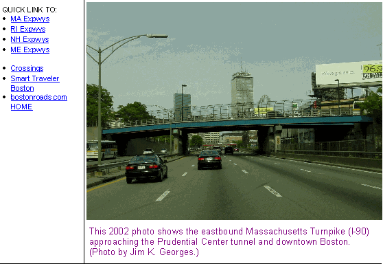
NEW CONNECTIONS OVER THE CHARLES RIVER: In late 1999, a four-lane, 830-foot-long span connecting I-93 with MA 28 and the Leverett Circle in Cambridge opened to traffic, utilizing some of the ramps intended for the unbuilt Inner Belt Expressway. Part of the $15 billion "Big Dig" project, the $23 million Leverett Circle Connector Bridge over the Charles River stands just west of the Leonard P. Zakim-Bunker Hill Bridge. The ten-lane Zakim Bridge, a asymmetrical cable-stay "signature span," began carrying four northbound lanes of I-93 in March 2003, and six southbound lanes in December 2003. Soon thereafter, the existing High Bridge, a dilapidated dual-deck Warren truss span, was torn down.
This 2001 photo shows the Northern Expressway (I-93) looking north from the Marble Street overpass in Stoneham. (Photo by Alexander Svirsky, massroads.com.)
RE-EXAMINING THE INTERCHANGE WITH I-95 (ROUTE 128): In 2001, the MHD resumed studies for a rebuilt interchange between I-93 and I-95 / MA 128 in Reading. Handling more than 350,000 vehicles per day (AADT), the 1950's-style cloverleaf interchange is a chokepoint for New Hampshire-bound traffic and suffers from a high accident rate. Amid concerns that the state would have to condemn as many as 90 properties in order to rebuild the interchange, some community groups sought to thwart the state's efforts. To address wider issues in the area of the interchange, the MHD initiated a new planning study in 2004 that involves the "I-93 / I-95 Interchange Task Force," which is made up of Federal and state agencies, state and local officials, community members and other interested organizations. Engineers reduced ramp design speeds to 40 MPH (from 50 MPH) to reduce property takings.
In its 2007 final design plan, the task force narrowed 16 alternatives down to the following two plans:
ALTERNATIVE H3-OS: A pair of new two-lane flyover ramps would be built for the southbound I-95 / MA 128 to southbound I-93 and northbound I-95 / MA 128 to northbound I-93 movements, replacing the existing loop ramps. The southbound I-93 to southbound I-95 / MA 128 and northbound I-93 to northbound I-95 / MA 128 ramps would be realigned to permit a higher design speed within the existing interchange right-of-way. This alternative was estimated to cost $160 million.
ALTERNATIVE H3-US: In this alternative, there would be a two-lane flyover ramp for the northbound I-95 / MA 128 to northbound I-93 movement and a two-lane "flyunder" ramp for the southbound I-95 / MA 128 to southbound I-93 movement. As in alternative H3-OS, the southbound I-93 to southbound I-95 / MA 128 and northbound I-93 to northbound I-95 / MA 128 ramps would be realigned to permit a higher design speed within the existing interchange right-of-way. This alternative was estimated to cost $249 million.
A final environmental impact statement and record of decision have yet to be made, and no construction dates have been established.
COPING WITH GROWING CONGESTION: According to the Massachusetts Department of Transportation (MassDOT), the successor to the MHD, the Northern Expressway carries approximately 180,000 vehicles per day (AADT) from Boston north to I-95 / MA 128 (Yankee Division Highway), approximately 135,000 vehicles per day from I-95 / MA 128 north to I-495 (Outer Circumferential Highway), and approximately 100,000 vehicles per day from I-495 north to the Massachusetts-New Hampshire border.
In the late 1990's, the MHD implemented an HOV lane along the southbound left lane of the Northern Expressway. The HOV lane, which is open to all vehicles outside the morning peak period, runs approximately two miles through Medford and Somerville. There is no corresponding HOV lane along the northbound lanes of I-93.
Since 1999, the MHD has permitted the use of the emergency shoulders as rush-hour travel lanes along the existing six-lane section from Wilmington north to the Massachusetts-New Hampshire border. However, many transportation experts believe that the shoulder lanes are at best a short-term measure to increase capacity, and at worst a safety and operational hazard.
In 2008, the state recommended widening I-93 to eight lanes (from six lanes) from EXIT 41 (MA 125) north to EXIT 44 (I-495), and it is likely the state will press to widen the remaining six-lane section north to the Massachusetts-New Hampshire border to eight lanes given plans to widen I-93 to eight lanes in the Granite State. Separate studies by the Merrimack Valley Planning Commission (MVPC) advised construction of a new EXIT 41A (Research Drive Extension) in Wilmington, which was first proposed in 1980, as well as a full extension of the eight-lane widening project all the way north to the Massachusetts-New Hampshire border.
In 2009, MassDOT recommended reconstruction of EXIT 46 (MA 110 / MA 113) in Methuen. The preferred alternative would replace the rotary with a modified cloverleaf interchange, requiring the displacement of four homes and two acres of wetlands, though modest improvements in traffic flow and air quality are projected. Final design of the $72 million interchange is scheduled for completion in 2014, with construction slated for completion in 2017.
This 2003 photo shows the northbound Northern Expressway (I-93) at EXIT 44 (I-495 / Outer Circumferential Highway) in Andover. (Photo by Jim K. Georges.)
I-93 should be expanded to eight lanes from Wilmington north to the Massachusetts-New Hampshire border. This widening would not require expansion of the Merrimack River Bridge, which already has four travel lanes and full shoulders in each direction.
A new four-level stack interchange should be constructed at EXIT 44 (I-495) in Andover. Right-of-way could be acquired more easily for expansion and safety improvements at this interchange than at EXIT 37 (I-95 / MA 128) in Reading.
SOURCES: Master Highway Plan for the Boston Metropolitan Area, Massachusetts Department of Public Works (1948); "A Report of Progress," Massachusetts Department of Public Works (1962); "Inner Belt and Expressway System," Massachusetts Department of Public Works (1962); Recommended Highway and Transit Plan, Massachusetts Department of Public Works (1968); "The Massachusetts Highway Story (1949-1969)," Massachusetts Department of Public Works (1969); Boston Transportation Planning Review: Final Study Summary Report, Massachusetts Department of Public Works (1972); "A Small New Road Called a Big Joke," The New York Times (2/11/1973); "I-93 / US 1 Interchange, Draft Environmental Impact and Section 4(f) Statement," Federal Highway Administration and Massachusetts Department of Public Works (1977); "Central Artery North Area Project, Final Environmental Impact and Section 4(f) Statement," Federal Highway Administration and Massachusetts Department of Public Works (1981); "I-93 Meets US 1: Checkered Past Led to Chaotic Present" by Peter J. Howe, The Boston Globe (11/26/1987); "More Ramps Off Tobin Open," The Boston Globe (9/08/1994); "New Ramps Are a Turn-Off" by Tom Palmer, The Boston Globe (11/02/1994); "Design Project: Industri-Plex" by Russ Spieler," Massachusetts Institute of Technology (1997); "Highway Needs Cause Safety Breakdown" by Mac Daniel, The Boston Globe (2/10/2002); "State Suspends Highway Study As Interchange Draw Fire" by Mac Daniel, The Boston Globe (9/26/2002); "Span Links Vision, Reality" by Doug Hanchett, The Boston Globe (10/06/2002); "Other Green Monster Falls: Central Artery Demolition To Be Complete Within a Year" by Anthony Flint, The Boston Globe (10/28/2003); "Interchange Redesign Back on the Board" by Alexander Reid, The Boston Globe (11/30/2003); "End of the Road: Artery Closes, Tunnel Opens" by Dave Wedge, The Boston Herald (12/20/2003); "I-93 Crossing Plans Develop" by Michael Marotta, The Boston Herald (10/06/2004); "I-93 / I-95 Interchange Transportation Study-Project Briefing," Massachusetts Highway Department (2004); I-93 / I-95 Interchange Transportation Study: Final Report, Massachusetts Executive Office of Transportation (2007); I-93 / Route 110 / Route 113 Interchange Reconfiguration and Reconstruction Project: Draft Environmental Impact Report, Massachusetts Department of Transportation (2009); John Carr; David Chesler; Adriel Edwards; Douglas Kerr; Dan Moraseski; George Sanborn; Paul Schlichtman; Alexander Svirsky; Yanni Tsipis.
I-93 shield by Ralph Herman. Central Artery / Tunnel shield by Massachusetts Turnpike Authority. Lightposts by Millerbernd Manufacturing Company. HOV sign by C.C. Slater.