
|
|
||
|
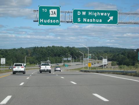
This 2019 photo shows the eastbound Nashua Circumferential Highway at the exit for Daniel Webster Highway in Nashua. (Photo by Steve Anderson.) |
||
|
Length: |
||
|
1.3 miles (2.1 kilometers) |
||

|
AN EASTERN BYPASS FOR NASHUA: In 1959, the New Hampshire Department of Public Works and Highways announced plans for a beltway connecting the F.E. Everett Turnpike (US 3) in Nashua with NH 111 and NH 102 in Hudson. The Nashua Circumferential Highway was planned as a 180-degree loop connecting EXIT 2 on the Everett Turnpike with EXIT 9 on the Everett Turnpike. The beltway was to not only provide a direct freeway connection with Nashua's eastern suburbs, but also relieve congestion on the Taylor Falls Bridge (NH 102-NH 111), which at the time was the only vehicular crossing for a 30-mile distance from Manchester south to Tyngsborough, Massachusetts. |
||
|
The state had established a preliminary route for the freeway, and the state's turnpike division began purchasing rights-of-way for the road, particularly in South Nashua and Hudson. In 1971, the state began work on a new Merrimack River crossing, the two-lane Sagamore Bridge, which included approach roads with surface intersections at Daniel Webster Highway and NH 3A. This route, which was built on the right-of-way reserved for the future Circumferential Highway, was opened to traffic in 1973. |
||
|
Even as the state built a new four-lane, twin-span bridge at the site of the old Taylor Falls Bridge (now called the Taylor Falls-Veterans Memorial Bridge) in the early 1970s, there still was a need to alleviate congestion through the downtowns of Nashua and Hudson. In 1981, the New Hampshire Department of Transportation (NHDOT) began environmental studies on the route of the Nashua Circumferential Highway and evaluated several alternatives. Three years later, the state decided on a preferred alignment, which it dubbed the "B-C" alignment as it combined the attributes of Alternate B and Alternate C, as follows: |
||
|
|
||
|
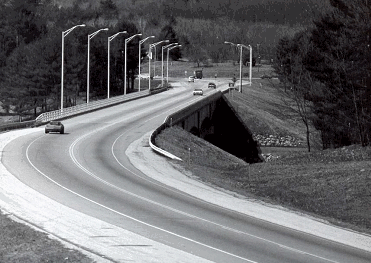
This 1976 photo shows the original Sagamore Bridge and the two-lane connector road. Note the signalized intersection ahead between the Sagamore Bridge connector and NH 3A past the bridge. (Photo by New Hampshire Department of Transportation.) |
||
|
THE SOUTHERN MERRIMACK RIVER CROSSING: It took nearly a decade from the release of the draft environmental impact statement in 1984 and the development of the final environmental impact statement in 1993, which had as its preferred alternative a "full-build" beltway alignment roughly similar to the "B-C" alignment selected earlier. Although the US Environmental Protection Agency (EPA) vetoed the full-build alternative the following year, the agency reached a compromise with Governor Steve Merrill and the NHDOT in 1995 to build the southern and northern segments of the freeway. However, only the southern segment was built. |
||
|
Construction of the Nashua Circumferential Highway began in 1997 and was conducted in conjunction with the Everett Turnpike widening project through Nashua. The project featured construction of a new parallel span built just to the south of the existing Sagamore Bridge, such that the new span would carry eastbound traffic, while the existing span, which was widened as part of the project, would carry westbound traffic. In addition to a new grade-separated interchange that replaced the existing at-grade intersection at Daniel W. Webster Highway, the four-to-six-lane freeway was built to connect to the new EXIT 2 on the Everett Turnpike. Construction of this interchange required the demolition of the existing state welcome center along the northbound lanes. The 1.3-mile-long expressway, which is signed as a spur of the Everett Turnpike, was completed on November 2, 1999. |
||
|
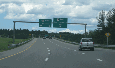
This 2017 photo shows the current eastern terminus of the Nashua Circumferential Highway at NH 3A (Lowell Road) in Hudson. (Photo by Steve Anderson.) |
||

|
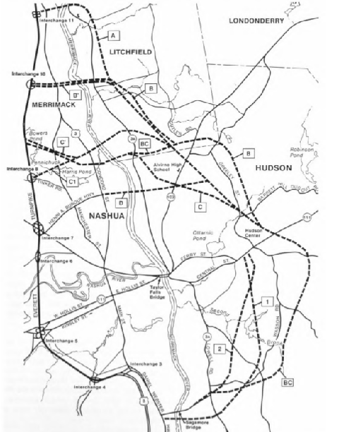
This map from the 1984 draft environmental impact statement shows the various alternatives for the Nashua Circumferential Highway. The 1984 report recommended that the "B-C" alternative from the Sagamore Bridge approach to Bowers Pond be adopted, and the 1993 final environmental impact statement recommended a similar alignment. (Map by New Hampshire Department of Transportation.) |
||
|
"In the 1990s we must find the right balance between protecting natural resources and growing our economy. This project does not strike that balance." - John Devillars, EPA New England Administrator in the agency's veto of the full-build alternative |
||
|
This map from the Town of Hudson's "BUILD" grant application report shows the proposed route of Hudson Boulevard within the NHDOT right-of-way. (Map by Town of Hudson.) |
||


|
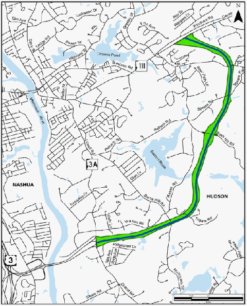
EXTEND THE "CIRC" TO NH 111: The Nashua Circumferential Highway should be extended as a full four-lane freeway from NH 3A to NH 111. Upon completion, the entire length of the road from the Everett Turnpike to NH 111 should be given the NH 311 designation. Furthermore, in conjunction with this project, the existing NH 111, from the terminus of the Nashua Circumferential Highway in Hudson to I-93 in Windham, should be expanded to a four-lane divided arterial. |
||

|
SOURCES: "Nashua-Hudson Circumferential Highway: Draft Environmental Impact Statement," New Hampshire Department of Transportation and Federal Highway Administration (1984); "New Hampshire Executive Council Votes To Hike All Highway Tolls," by Adolphe V. Bernotas, The Boston Globe (10/12/1989); "US Orders New Nashua Road Study" by Robert Braile, The Boston Globe (6/03/1990); "Nashua-Hudson Circumferential Highway: Final Environmental Impact Statement," New Hampshire Department of Transportation and Federal Highway Administration (1993); "Press Release: EPA Puts a Halt on Nashua Circumferential Highway," US Environmental Protection Agency (3/31/1994); "EPA Sounds Death Knell for Bypass" by Kevin Landrigan, The Nashua Telegraph (4/01/1994); "NH Drops Its Nashua Road Plan" by Robert Braile, The Boston Globe (8/23/1995); "Circumferential Highway White Paper," Nashua Regional Planning Commission (2003); "Transportation Emergency Preparedness Plan for the Nashua Region," Nashua Regional Planning Commission (2010); "Hudson Boulevard: BUILD Grant Application," Town of Hudson (2018); "Hudson Board of Selectmen Opt Not To Include Major Roadway Project in Town Warrant" by Ryan Lessard, New Hampshire Union-Leader (1/13/2019). |
||
|
NASHUA CIRCUMFERENTIAL HIGHWAY LINKS: |
||
|
NASHUA CIRCUMFERENTIAL HIGHWAY CURRENT TRAFFIC CONDITIONS: |
||
|
NASHUA CIRCUMFERENTIAL HIGHWAY EXIT LIST: |
||


|
Back to The Roads of Metro Boston home page. |
||
|
Site contents © by Eastern Roads. This is not an official site run by a government agency. Recommendations provided on this site are strictly those of the author and contributors, not of any government or corporate entity. |
||