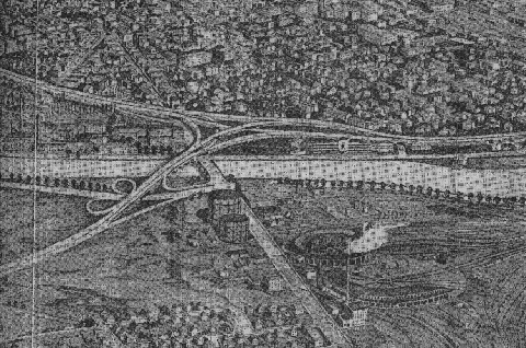
This artist's conception from 1948 shows the proposed Inner Belt Expressway (I-695, running from the lower left to the right) at the Charles River Bridge and the proposed interchange with the Western Expressway (early I-90 alignment, running to the upper left). The Boston and Albany Railroad yard in the foreground was later acquired as part of the right-of-way for the Massachusetts Turnpike (I-90). (Figure by Massachusetts Department of Public Works.)
AN INNER BYPASS FOR DOWNTOWN BOSTON: In 1948, the Massachusetts Department of Public Works (MassDPW), led by commissioner William F. Callahan, proposed a controlled-access, multi-lane loop route to connect downtown Boston with other radial expressways. By serving crosstown traffic, the "Belt Route" was to relieve a large portion of the 15,000 through trips on Boston's antiquated street network.
Forming a 7.3-mile-loop around the southern, western and northern edge of downtown Boston, the route of the Inner Belt Expressway was described in the Master Highway Plan for the Boston Metropolitan Area as follows:
The selected route begins at the interchange between the Southeast and Southwest expressways near Massachusetts Avenue and Southampton Street, and extends in a westerly direction via Roxbury Crossing to connect with Huntington Avenue, Jamaica Way and Brookline Avenue. From this point, it extends in a northerly direction to cross Beacon Street and Commonwealth Avenue paralleling the Cottage Farm (Boston University) Bridge across the Charles River to connect with the Western Expressway (early I-90 alignment). From this point, the Belt Route passes through Cambridge in a northeasterly direction to Somerville, making an interchange connecting with the Northwest Expressway (unbuilt US 3-MA 2) in the vicinity of Washington Street. From this interchange, it travels in an easterly direction paralleling the Boston and Maine Railroad, crossing its main yards to an elevated interchange just west of City Square, where it connects with the Northeast Expressway (US 1).
Interchanges were to be constructed at the following locations:
Southeast Expressway (I-93) / Southwest Expressway (unbuilt I-95), Boston
Washington Street, Boston Columbus Avenue, Boston Brookline Avenue, Boston Worcester Turnpike (MA 9), Brookline Beacon Street, Boston Commonwealth Avenue, Boston Soldiers Field Road, Boston Western Expressway (early I-90 alignment), Cambridge Massachusetts Avenue (MA 2A), Cambridge Northwest Expressway (unbuilt US 3-MA 2), Cambridge Northern Artery / Medford Boston, Somerville Northeast Expressway (US 1), Somerville
The Inner Belt Expressway was to continue south along the route of the elevated Central Artery, providing connections to downtown Boston and Logan Airport. Note that there was to be no direct connection to the Northern Expressway (I-93), due to its close location between the Northwest and Northeast expressways. (Engineers sought adequate spacing of access points to controlled-access routes.)
DESIGN CONVENTIONS: The Inner Belt Expressway was to adhere to the design conventions recommended in the 1948 Master Highway Plan: six 12-foot-lanes separated by a variable median, 12-foot-wide emergency shoulders and flanking service roads within a 300-foot-wide right-of-way. However, along the depressed sections in more heavily urbanized areas, the six-lane expressway was to be constructed within a 170-foot-wide right-of-way. The expressway, which had a design speed of 50 MPH, was designed to handle approximately 55,000 vehicles per day (AADT). More specific, Interstate-compatible design recommendations called for 14½-foot bridge clearances and continuous shoulders on viaducts.
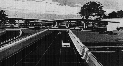
This artist's conception from 1965 shows the southbound Inner Belt Expressway (I-695) at the MA 2 Expressway interchange in Cambridge. The MA 2 Expressway was originally conceived as part of the Northwest Expressway (US 3) system. (Figure by Massachusetts Department of Public Works.)
PART OF THE INTERSTATE NETWORK: Officials from the MassDPW sought to include the Inner Belt as part of the proposed Interstate highway network being developed in the late 1940's. In 1955, the Federal Bureau of Public Roads (BPR) included the Inner Belt as part of the preliminary national network, ensuring that the MassDPW would be reimbursed for 90 percent of the $44 million cost. Much of the route was to receive the I-695 designation; a small section between the Southeast and Southwest expressways was to receive the I-95 designation.
Under the BPR proposal, the route was amended so that the termini of the Southeast and Southwest expressways were placed further apart along the Inner Belt, rather than terminating at one location. Beginning at the I-95 / I-695 interchange (in the vicinity of the Ruggles MBTA-Orange Line station) in Roxbury, I-695 was to run northwest along Ruggles Street, between Fenway and Park Drive, and north to the Boston University Bridge. Crossing the Charles River (either over a bridge or under a tunnel) into Cambridge, it was to run just west of Brookline Street to Central Square, and thence along Elm Street to the Cambridge-Somerville line, where I-695 was to intersect the Northwest Expressway (US 3-MA 2) and turn east. I-695 was to end at a new direct interchange with the elevated Northern Expressway (I-93) in Somerville.
Despite the inclusion in the Interstate system, the MassDPW still had to come up with funds for construction and right-of-way acquisition during the late 1950's and early 1960's. With this in mind, John A. Volpe, now MassDPW commissioner, sought to terminate the proposed Western Expressway (I-90) at the Inner Belt in Cambridge, on the north side of the Charles River. Callahan, now chairman of the Massachusetts Turnpike Authority, sought to extend his toll alternative, the Massachusetts Turnpike, east to the Central Artery (I-93) in downtown Boston, stating that Federal funding for the Inner Belt (I-695) and the free Western Expressway was uncertain, and that no engineering studies had been made for either route.
PART OF THE INTERSTATE NETWORK: Officials from the MassDPW sought to include the Inner Belt as part of the proposed Interstate highway network being developed in the late 1940's. In 1955, the Federal Bureau of Public Roads (BPR) included the Inner Belt as part of the preliminary national network, ensuring that the MassDPW would be reimbursed for 90 percent of the $44 million cost. Much of the route was to receive the I-695 designation; a small section between the Southeast and Southwest expressways was to receive the I-95 designation.
Under the BPR proposal, the route was amended so that the termini of the Southeast and Southwest expressways were placed further apart along the Inner Belt, rather than terminating at one location. Beginning at the I-95 / I-695 interchange (in the vicinity of the Ruggles MBTA-Orange Line station) in Roxbury, I-695 was to run northwest along Ruggles Street, between Fenway and Park Drive, and north to the Boston University Bridge. Crossing the Charles River (either over a bridge or under a tunnel) into Cambridge, it was to run just west of Brookline Street to Central Square, and thence along Elm Street to the Cambridge-Somerville line, where I-695 was to intersect the Northwest Expressway (US 3-MA 2) and turn east. I-695 was to end at a new direct interchange with the elevated Northern Expressway (I-93) in Somerville.
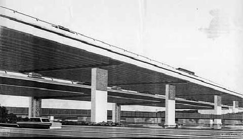
One alternate design for the Inner Belt (I-695) across the Charles River featured a new box-girder bridge. Planned as the replacement for the Boston University Bridge (a steel-arch span that still stands today), the Inner Belt was to be routed on the upper level, while local traffic was to be routed on the lower level. The low-lying Boston and Albany railroad bridge would have remained. (Figure by Massachusetts Department of Public Works.)
CONTROVERSY SPREADS ALONG THE BELT: As demolition along the Inner Belt right-of-way began in Roxbury and the South End in the early 1960's, residents, civic leaders and academics in Cambridge organized a coalition of different community groups along the route to oppose the Inner Belt. This coalition received some ammunition from the State Legislature, which in 1960 granted local communities veto power over highway projects.
Fred Salvucci, who later served as transportation secretary under Governor Michael Dukakis in the 1970's and 1980's, was one of the leaders of the anti-Inner Belt protests. A civil engineering graduate from the Massachusetts Institute of Technology (MIT), Salvucci served as transportation consultant to Mayor Kevin White, and his opinions had significant influence with city and state officials. Salvucci's battle even caught the attention of Representative Thomas P. ("Tip") O'Neill, who protested the potential destruction of neighborhoods along the route. Soon, the protests against the Inner Belt spread to Beacon Hill and Capitol Hill.
O'Neill, who later served as Speaker of the House and advocated the "Big Dig" project at the end of his career, questioned the need for the Inner Belt in the following response to Lowell K. Bridwell, the chairman of the Federal Highway Administration (FHWA):
It's been 19 years since a basic study has been made on the need for this road. Both (the Inner Belt and the Southwest Expressway) would create a China Wall dislocating 7,000 people just to save someone in New Hampshire 20 minutes on his way to the South Shore.
A RE-EVALUATION OF TRANSPORTATION PRIORITIES: By the dawn of the 1970's, momentum had shifted against the Inner Belt. Volpe, longtime MassDPW commissioner and now transportation secretary under President Nixon, promised a more balanced national transportation policy, and campaigned for a transfer of urban highway funds to mass transit. In February 1970, Governor Francis Sargent ordered a moratorium on all new expressway construction within MA 128 (Yankee Division Highway), and ordered a review of expressway and transit plans in the Boston area.
From the governor's action, the Boston Transportation Planning Review (BTPR) was born. To kick off the BTPR, Governor Sargent made the following policy statement:
The plan will be based on not where expressways should be built, but whether expressways should be built. It will integrate road-building with mass transit, and it will study some of these other, imaginative means of moving goods and people: park-and-ride systems, metered traffic on expressways, special bus lanes, and the host of other space-age approaches now available to transportation planners.
Four years ago, I was the commissioner of the Massachusetts Department of Public Works, our road-building agency. Then, nearly everyone was sure that highways were the only answer to transportation problems for years to come. We were wrong. Today, we know more clearly what are real needs are: what our environment means to us, what a community means to us, and what is valuable to us as a people.
In the BTPR Phase II report, which was released in December 1971, Governor Sargent canceled the eight-lane I-695 alignment from the Massachusetts Turnpike (I-90) north and east to the Northern Expressway (I-93) - the Brookline-Elm and Portland-Albany alignments - through Cambridge and Somerville. MassDPW officials recognized that new Federal relocation requirements "made impossible" construction of the route as originally proposed through the Cambridge-Somerville area. However, the report did feature the following modifications for I-695:
From the Massachusetts Turnpike (I-90) south and east to the Southeast Expressway (I-93, US 1 and MA 3), there was to be a six-lane alignment along the original route through the South End. Four lanes were to be general-use lanes, while the two innermost lanes were to be reserved for HOV use.
From the Massachusetts Turnpike (I-90) north and east to the Northern Expressway (I-93), a possible four-lane of extension of I-695 through Cambridge and Somerville was proposed along the Grand Junction railroad right-of-way, minimizing community disruption. The downscaled I-695 through the Cambridge-Somerville area was to serve primarily (or exclusively) trucks and buses, taking commercial traffic off local streets.
Near the conclusion of BTPR studies in November 1972, Governor Sargent eliminated the entire Inner Belt Expressway (I-695 and I-95) from further consideration, citing that no "feasible and prudent" alternative route could be constructed through the area. On May 23, 1974, the unbuilt I-695 and I-95 through Boston were among the first Interstates to be traded in for transit funds under the Federal Highway Act of 1973.
INNER BELT REDUX? After the Inner Belt was canceled, the 1.3-mile-long, four-lane Melnea Cass Boulevard was constructed along the former Inner Belt (I-95 section) right-of-way, and today connects I-93 with Massachusetts Avenue and Columbus Avenue (MA 28) in South Boston. Several other vestiges, such as the unfinished exit ramps at the Northern Expressway (I-93) in Somerville and the "directional-T" interchange at EXIT 18 (Melnea Cass Boulevard-Massachusetts Avenue), reveal long-abandoned attempts to construct the Inner Belt.
Despite widespread opposition, some have continued to argue that I-695 would have relieved chronic congestion on the Central Artery. More than 25 years after Governor Sargent canceled the Inner Belt, Kevin J. Sullivan, the transportation commissioner under Governor Paul Celluci, surprised a seminar audience by suggesting that the Inner Belt should have been constructed. While not suggesting a revival of I-695, Sullivan did emphasize the need for persistence in controversial projects such as the "Big Dig."
In the late 1990's, the Massachusetts Bay Transportation Authority (MBTA) conducted a major investment study (MIS) for a circumferential corridor located just beyond the Boston central core, roughly along the route of the Inner Belt. The transit alternatives, which range from $20 million for bus service to $1.4 billion for a new rail system, would connect with existing commuter rail and transit lines.
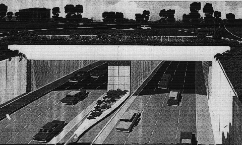
Another alternate design for the Inner Belt (I-695) under the Charles River featured a new eight-lane tunnel. In this alternative, the existing Boston University Bridge, as well as the Boston and Albany railroad bridge, would have remained. (Figure by Massachusetts Department of Public Works.)
SOURCES: Master Highway Plan for the Boston Metropolitan Area, Massachusetts Department of Public Works (1948); "A Report of Progress," Massachusetts Department of Public Works (1962); "Inner Belt and Expressway System," Massachusetts Department of Public Works (1962); "Boston Inner Belt Expressway," Massachusetts Department of Public Works (1965); Recommended Highway and Transit Plan, Massachusetts Department of Public Works (1968); "The Massachusetts Highway Story," Massachusetts Department of Public Works (1969); "Drive in Boston May Bring a New Urban Transit Mix" by Bill Kovach, The New York Times (7/24/1970); "Southwest Corridor Study," Massachusetts Department of Public Works (1970); Superhighway - Superhoax by Helen Leavitt, Doubleday and Company (1970); Rites of Way: The Politics of Transportation in Boston and the U.S. City by Alan Lupo, Frank Colcord and Edmund P. Fowler, Little, Brown and Company (1971); "Mass Transit Plan for Massachusetts" by Bill Kovach, The New York Times (11/30/1972); Boston Transportation Planning Review: Final Study Summary Report, Massachusetts Department of Public Works (1972); Divided Highways by Tom Lewis, Viking-Penguin Books (1997); "Sullivan's Lament for Inner Belt Reopens Sore Highway Subject," The Boston Globe (1/22/1999); "50 Years as the BU Bridge," BU Bridge-Boston University (5/14/1999); "The Last Road to Boston" by Yanni Tsipis, Massachusetts Institute of Technology (1999); "Starts and Stops: Historic Ramp" by Mac Daniel, The Boston Globe (5/27/2007); U.S. Department of Transportation; Dan Moraseski; Scott Moore; Ron Newman; Scott Oglesby; Fred Salvucci; George Sanborn; Paul Schlichtman.


