
|
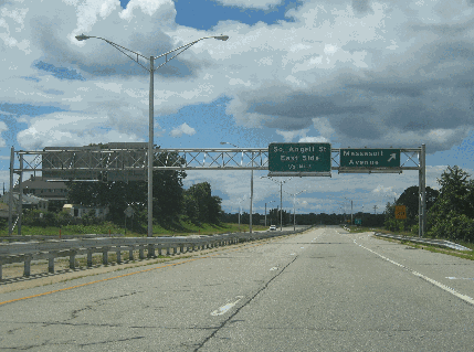
This 2010 photo shows the westbound Henderson Expressway (no numbered designation) at the Massaoit Avenue exit in East Providence. Note the bike lane in the right shoulder of the expressway. (Photo by Steve Anderson.) |
||

|
CONNECTING THE EAST SIDE WITH EAST PROVIDENCE: The earliest Seekonk River crossing near the current site of the Henderson Expressway dates back to 1793, when noted New England industrialist and abolitionist Moses Brown had a bridge built to connect Waterman Street in Providence and Waterman Avenue in East Providence. Called the "Red Bridge" because of the color it was painted (and alternately called the "Central Bridge," the bridge was a wooden truss bridge with six pile piers. There was a 24-foot-long draw span at the western end of the bridge. The original Red Bridge was destroyed by a storm in 1807. |
||
|
That same year, a new Red Bridge--also made of wood and painted red--was built on the same site. It was built to nearly the same specifications as the original span, but new rubble pilings were built around the original ones as they had deteriorated significantly after the storm. In 1859, the Rhode Island General Assembly passed a law requiring all Seekonk River crossings to have a horizontal clearance of at least 38 feet. The draw on the bridge was widened in accordance with the new law, but as vessels on the Seekonk River grew larger, a new Red Bridge seemed inevitable. |
||
|
On May 28, 1869, the Rhode Island General Assembly passed a law authorizing construction of a new bridge with a moveable span of at least 80 feet in the center of the river, not on the west side where the old draw span had been. Unlike the two previous bridges, which were made of wood and featured a draw span, the new 390-foot-long Red Bridge was built of iron and featured a swing span operated by hand power. The bridge was completed in 1872, and in 1895 it was upgraded with a mechanically-operated swing span, as well as strengthened to accommodate streetcar traffic. |
||
|
A NEW EXPRESSWAY APPROACH: In the late 1950s, the Rhode Island Department of Public Works (RIDPW) endorsed a plan for a new US 44 Expressway that would extend from I-195 (East Providence Expressway) at EXIT 3 along Gano streets in Providence, turning east over a new Seekonk River bridge 300 yards north of the existing Red Bridge, and then on new right-of-way to Taunton Avenue (US 44) in East Providence. The proposed route was to tie into plans being developed by the Massachusetts Department of Public Works (MassDPW) to extend the US 44 Expressway into the Bay State. The bridge itself was named in 1960 after George H. Henderson, who had served as chief engineer at the RIDPW for many years. |
||
|
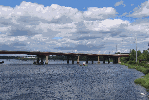
Through much of the 1960s, the RIDPW focused on finishing up the state's Interstate highway network, but toward the end of that decade, the state built several key pieces of the state's primary freeway network, of which the new "Red Bridge" was a part. The 1,903-foot-long bridge has seven spans, with its fixed center span over the navigable channel; its girders were painted red in a nod to the old "Red Bridges" that stood nearby. A viaduct approach on the east side of the span crosses a (now-abandoned) railroad right-of-way and Massaoit Avenue. The western end of the bridge approach ties into Angell and Waterman streets in Providence--the approach "exits" onto Angell Street from a "stub" highway--while the eastern expressway approach on the East Providence side has grade-separated interchanges at Massaoit Avenue and Broadway. The $7 million bridge and approach costs were completed in 1969. |
||
|
This 2010 photo shows the Henderson Bridge looking north from the end of Waterman Avenue in East Providence. Waterman Avenue was the site of the old Red Bridge, and remnants of old iron railings hint at the existing of the old bridge. (Photo by Steve Anderson.) |
||

|
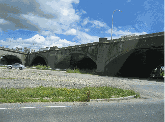
This 2010 photo shows the East Providence Expressway (I-195) crossing the Washington Bridge at EXIT 3 (Gano Street) in Providence. The original construction of I-195 incorporated a trumpet interchange at EXIT 3 for a proposed connection to the US 44 Expressway, and large guide signs for EXIT 3 left spaces for future insertion of US 44 shields. Most of the trumpet interchange was removed during the reconstruction of I-195 in the mid-to-late 2000s. (Photo by Steve Anderson.) |
||
|
TO THE WEST: I-195 OR DOWNTOWN? The official RIDOT plan had the US 44 Expressway extending from the Henderson Bridge south along the west bank of the Seekonk River, then intersecting with I-195 near Gano Street. A "trumpet" interchange was built in anticipation of the US 44 Expressway, but most of the ramps were demolished during the reconstruction of I-195 in the mid-to-late 2000s. |
||
|
However, the Providence City Plan Commission floated a competing proposal in 1961 for the US 44 Expressway. Instead of shifting US 44 south to I-195, the commission suggested extending the highway through the city's East Side by paving the existing railroad tunnel to Downtown to connect US 44 with I-95 (North-South Expressway) and the "6-10 Connector" (Huntington Expressway). The "East-West Connector" was to improve access to Downtown and I-95 while enhancing the College Hill neighborhood by taking traffic off Waterman and Angel streets. Both proposals were dropped in the 1970s. |
||
|
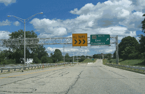
This 2010 photo shows the eastern terminus of the Henderson Expressway at Broadway in East Providence. The RI 152 designation shown in this photo is incorrect, but may have been part of state plans in the 1960s to extend the RI 152 designation from its present terminus at Newman Avenue and US 1A (Pawtucket Avenue) south along Broadway. (Photo by Steve Anderson.) |
||


|
EXTEND THE ROUTE TO TAUNTON AVENUE: The Henderson Expressway should be extended three-quarters of a mile east to Taunton Avenue as a surface arterial along the currently unused right-of-way. Upon completion, the US 44 designation should be shifted from Taunton Avenue onto the expressway; the relocated US 44 then should be routed on Angell and Waterman streets through Providence's East Side. |
||
|
SOURCES: "Executive Documents: First Session, 43rd Congress," Government Printing Office (1874); "Rhode Island Roads," Rhode Island Department of Public Works (1956); "A Highway Program for Rhode Island," Rhode Island Department of Public Works (1959); Downtown Providence 1970, Providence City Plan Commission (1961); Southeastern Massachusetts Comprehensive Transportation Plan," Massachusetts Department of Public Works (1969); "Planners Endorse Waterfront Proposal" by Katherine Gregg, The Providence Journal (12/06/1984); "Interim Ground Transportation Plan: 2010," Rhode Island Department of Transportation (1992); East Providence by East Providence Historical Society, Arcadia Publishing (1997); Providence by Louis McGowan and Daniel Brown, Arcadia Publishing (2006); "DOT: Bridge Needs $50 Million in Repairs," WJAR-TV (4/17/2008); Steve Alpert; Shawn DeCesari; Michael Kendricks; Sonja Shield; Alexander Svirsky. |
||
|
HENDERSON EXPRESSWAY LINKS: |
||
|
HENDERSON EXPRESSWAY CURRENT CONDITIONS: |
||

|
OFF-SITE EXIT LISTINGS: |
||
|
Back to The Roads of Metro Boston home page. |
||
|
Site contents © by Eastern Roads. This is not an official site run by a government agency. Recommendations provided on this site are strictly those of the author and contributors, not of any government or corporate entity. |
||