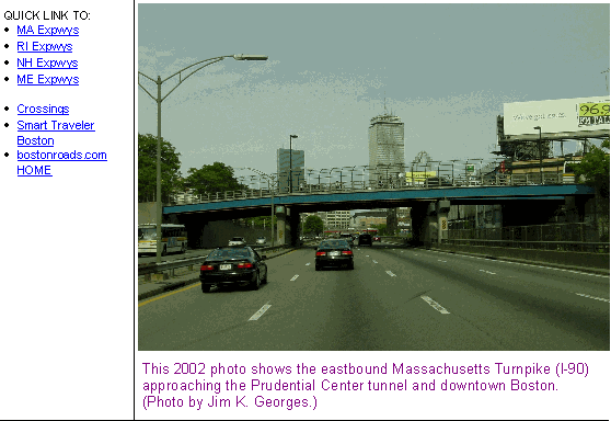
This 2003 photo shows the southbound East Boston Expressway (MA 1A) at the left-exit ramp for the Massachusetts Turnpike (I-90) near Logan Airport in East Boston. (Photo by Jim K. Georges.)
BOSTON'S FIRST EXPRESSWAY: In 1948, William F. Callahan, commissioner of the Massachusetts Department of Public Works (MassDPW), proposed an expressway to connect Logan International Airport with downtown Boston. Anticipating increased traffic loads, he proposed that the East Boston Expressway be constructed in conjunction with a second two-lane tunnel to supplement the existing two-lane Sumner Tunnel.
The Master Highway Plan for the Boston Metropolitan Area released that year described the need for the East Boston Expressway as follows:
Two major desire lines of vehicular traffic terminate in the East Boston-Revere area. The volumes indicated are much lighter than on any other expressway section in the Boston Metropolitan Area. It is also noted that movements are relatively short between termini. Presently, the existing two-lane Sumner Tunnel, connecting inadequate through routes with Logan Airport and MA 1A to the northeast, serves this traffic. This facility is now overtaxed primarily because it is being used traffic being detoured from other less desirable routes. Present plans contemplate the immediate improvement of connections from the existing tunnel to Logan Airport and the northeast. This improved facility, known as "East Boston Elevated Highway," is designed to connect the Sumner Tunnel with the airport, and to provide a high-speed expressway through East Boston to connect with the existing four-lane semi-expressway to the North Shore.
The 1.2-mile-long elevated expressway, which was expected to carry 30,000 vehicles per day (AADT), was estimated to cost $8.5 million.
Almost immediately, the MassDPW embarked on constructing the East Boston Expressway. Stretching about one mile from the portals for the Sumner and Callahan tunnels, the six-lane expressway immediately rises above the streets of East Boston, and furnishes access to and from Logan Airport before touching down at McClellan Highway (MA 1A), a four-lane arterial highway.
Completed in 1951, the East Boston route was the first expressway completed within the city of Boston. Originally designated C-1, the expressway received the MA 1A designation in the late 1970's. (The route was designated US 1 for an interim period in the mid-1970's.)
In 1977, the MassDPW spent $10 million and seven months to rebuild the elevated roadway sections, but the expressway remained beset by design flaws such as sharp curves, a lack of shoulders, and inadequate acceleration-deceleration lanes. Additional work in the early-to-mid 2000s addressed some of these issues, as well as provided new links to Logan Airport and the new Massachusetts Turnpike (I-90) extension.
According to the Massachusetts Highway Department (MHD), the East Boston Expressway carries approximately 50,000 vehicles per day.
A "BIG DIG" FOR EAST BOSTON? The redevelopment along the Central Artery prompted by the Central Artery ("Big Dig") project prompted one Boston planner, Antonio DiMambro, to move MA 1A from the existing elevated structure to a six-lane tunnel, with the aim of reconnecting the north and south sides of East Boston. Originally considered as part of the larger "Big Dig" project, state officials were unable to get highway funding for the East Boston project. A 2004 MIT study pegged the cost of the tunnel, which would be approximately four-tenths of a mile long, at $300 million.
From "Greater Boston Transportation: Projects for the Improvement of East Boston:"
The highway tunnels would be constructed using the same methods as the Central Artery tunnels. Concrete slurry walls would be placed in trenches along the edges of the highway, which eventually would form the lining of the tunnel. Steel columns connected to the slurry walls would support the entire weight of the elevated highway. This would ensure that traffic could continue to flow on the elevated highway while the tunnels are constructed. Once the slurry walls are in place and the elevated highway is supported, tunneling can proceed.
Toward the end of the project, the connection of the Sumner and Callahan Tunnels with the new highway tunnel, the existing tunnels would have to be closed to traffic until the switch is complete. This could cause a major disruption to the 82,000 vehicles per day that currently travel through the tunnels according to (the Massachusetts Turnpike Authority). One way to try to minimize the impact would be to close only one tunnel at a time; one tunnel, in conjunction with the Ted Williams Tunnel, should be able to keep traffic flow between Boston and East Boston at an adequate level for a short period of time.
This 2003 photo shows the northbound East Boston Expressway (MA 1A) at MA 145 (Bennington Street) in East Boston. (Photo by Jim K. Georges.)
EXTENDING THROUGH REVERE AND SAUGUS: In 1962, the MassDPW first proposed extending the East Boston Expressway roughly along the existing MA 1A, MA 60 and MA 107 through East Boston, Revere and Saugus. The proposed extension was to terminate at the Northeast Expressway (unbuilt I-95) near the Saugus River. Parts of the existing MA 1A (McClellan Highway) would have been upgraded to freeway standards, while other sections of the expressway were to be constructed on new rights-of-way.
Six years later, in its Recommended Highway and Transit Plan, the MassDPW advocated construction of a "Shore Expressway" that was to incorporate the East Boston Expressway and a connection to a proposed "New Harbor Crossing" (later built as the Ted Williams Tunnel). The expressway was cited as a key component of the "New Harbor Crossing" plan as follows:
A New Harbor Crossing is not a complete solution without other improvements. The new crossing would carry 72,000 vehicles per day by 1990 and would provide sufficient capacity for all forecast traffic. On the north side of the water, however, complications arise. Both this crossing, the Sumner Tunnel and the Callahan Tunnel funnel traffic onto Route C-1, which is projected to carry approximately 100,000 vehicles per day just north of Logan Airport, and slightly over 70,000 vehicles per day near Bell Circle in Revere. Between Bell Circle and I-95 in Saugus, the average volume forecast for Routes C-1 and 107 is 58,000 vehicles per day.
To accommodate these volumes adequately and provide system continuity, a "Shore Expressway" should connect the New Harbor Crossing with I-95 in Saugus. The construction of an expressway and New Harbor Crossing between I-95 in Saugus and the Central Artery near South Station would eliminate the need to increase the capacity of the existing Northeast Expressway, Tobin Bridge, Sumner Tunnel, and Callahan Tunnel.
WOULD I-95 HAVE BEEN RELOCATED? In 1970, Governor Francis Sargent ordered a moratorium on all new expressway construction within MA 128 (Yankee Division Highway), and ordered a review of expressway and transit plans in the Boston area. The Boston Transportation Planning Review (BTPR) advocated construction of a "relocated I-95" from South Boston to Saugus via the Third Harbor Tunnel, Logan Airport property and "Shore Expressway" alignment. At that time, I-95 was routed along the Central Artery and Northeast Expressway, two congested routes that were not constructed to Interstate standards. The 4.7-mile-long relocated I-95 from East Boston to Saugus was estimated to cost $19 million.
WOULD I-95 HAVE BEEN RELOCATED? In 1970, Governor Francis Sargent ordered a moratorium on all new expressway construction within MA 128 (Yankee Division Highway), and ordered a review of expressway and transit plans in the Boston area. The Boston Transportation Planning Review (BTPR) advocated construction of a "relocated I-95" from South Boston to Saugus via the Third Harbor Tunnel, Logan Airport property and "Shore Expressway" alignment. At that time, I-95 was routed along the Central Artery and Northeast Expressway, two congested routes that were not constructed to Interstate standards. The 4.7-mile-long relocated I-95 from East Boston to Saugus was estimated to cost $19 million.
The conclusion of the BTPR Phase I report (dated December 29, 1971) made the following recommendation for the relocated I-95:
The relocated I-95 will extend from South Station through a Third Harbor Crossing to a connection with either (the existing) I-95 or the Revere Beach Parkway. The scale of the roadway to be considered is four lanes, or six lanes in which two lanes are reserved for buses and special purpose vehicles. The originally proposed alignment through heavily residential areas of East Boston and Revere will be dropped from further consideration. All Third Harbor Crossing alternatives carried into Phase II will pass through Logan Airport property, to the east of the originally proposed alignment, and would not require the taking of any homes in East Boston. The I-95 alternatives through Revere would follow either the Boston and Maine Railroad right-of-way and the edge of Saugus Marsh, or a widened Northeast Expressway and Revere Beach Parkway.
During BTPR Phase II studies in June 1972, Governor Sargent announced the elimination of the originally proposed route of the I-95 (Northeast Expressway) section through Saugus Marsh and the Lynn Woods Reservation, citing that no "feasible and prudent" alternative route could be constructed through the area. Subsequently, the governor canceled plans for extending the East Boston Expressway through Revere and Saugus.
This aerial photo from the early 1970's shows the East Boston Expressway (MA 1A) just north of Logan International Airport. A 1972 plan shows a realigned expressway just to the left of the existing alignment, continuing past the terminus of the existing expressway. It may have been part of a relocated I-95. (Photo by Massachusetts Department of Public Works.)
SOURCES: Master Highway Plan for the Boston Metropolitan Area, Massachusetts Department of Public Works (1948); "A Report of Progress," Massachusetts Department of Public Works (1962); "Inner Belt and Expressway System," Massachusetts Department of Public Works (1962); Recommended Highway and Transit Plan, Massachusetts Department of Public Works (1968); "The Massachusetts Highway Story," Massachusetts Department of Public Works (1969); Boston Transportation Planning Review: Final Study Summary Report, Massachusetts Department of Public Works (1972); "Harbor Crossing Draft Environmental Impact Statement and Section 4(f) Statement," Massachusetts Department of Public Works (1972); "Boston Construction Job Starts Tomorrow," The Nashua Telegraph (4/18/1977); "Greater Boston Transportation: Projects for the Improvement of East Boston," Massachusetts Institute of Technology (2004); Massachusetts Department of Transportation; Dan Moraseski; Fred Salvucci; George Sanborn; Paul Schlichtman; Alexander Svirsky; Yanni Tsipis.
MA 1A and I-95 shields by Ralph Herman. Lightposts by Millerbernd Manufacturing Company.


