
|
TWO SPURS TO THE NORTH SHORE: In 1962, Massachusetts Department of Public Works (MassDPW) introduced for the first time a connector road from the proposed I-95 (Northeast Expressway) in Peabody to Salem and Beverly. Planning for the Beverly-Salem Connector was coordinated with the I-95 project. Four years later, the MassDPW proposed a new four-lane Beverly-Salem Bridge and interchange ramps to serve as the terminus of the proposed expressway connector. The new bridge was to replace a two-lane, low-level steel swing bridge constructed in 1897. |
||
|
I-95 CANCELLATION PROMPTS CHANGES: In 1970, Governor Francis Sargent ordered a moratorium on all new expressway construction within MA 128 (Yankee Division Highway), and ordered a review of expressway and transit plans in the Boston area. The Boston Transportation Planning Review (BTPR), which resulted from the governor's action, ultimately canceled the unbuilt section of I-95 through Saugus and Lynn. |
||
|
Since the Lynn Woods alignment is now officially dead, a connector that had been designed to connect Beverly, Salem and Swampscott to I-95 cannot be implemented. The Planning Review, however, has identified a corridor that runs mostly along existing railroad right-of-way from Salem through Peabody, in which a new four-lane arterial street could provide greatly improved access from North Shore communities to MA 128 with minimal disruption. The plan appears to command widespread support from officials and citizens of both Peabody and Salem. Improved access to from Marblehead and Swampscott to the Beverly-Salem Connector will also be studied. |
||
|
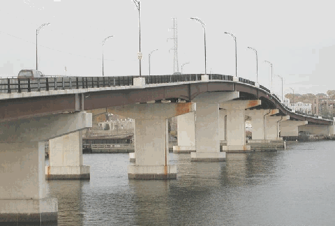
This 2002 photo shows the Veterans Memorial Bridge (MA 1A) spanning the Danvers River between Beverly and Salem. Completed in 1996, the bridge was built with funds allocated for the unbuilt Beverly-Salem Connector. (Photo by Alexander Svirsky, massroads.com.) |
||
|
THE BEVERLY-SALEM BRIDGE: Even with the cancellation of the connector, the need for a new Beverly-Salem Bridge was apparent by the late 1980's. By that time, the 90-year-old span had become functionally obsolete and structurally deficient. In 1990, the FHWA approved plans for a new four-lane, high-level Beverly-Salem Bridge across the Danvers River. The new span, which is named officially as the "Veterans Memorial Bridge," opened to traffic on August 2, 1996. |
||
|
The new bridge - the third one on the site (before the 1897 span, another bridge was built in 1788 in the same location) - is a seven-span girder bridge with a main 220-foot-long main span, two 190-foot-long spans, two 170-foot-long spans, and two 120-foot-long spans. At the southern end of the bridge, there are four approach spans leading to Bridge Street in Salem. The Bridge Street approach ends at a T-intersection with the bridge and a currently unused four-lane, three-span approach that continues in a straight line south from the bridge. |
||

|
SOURCES: Recommended Highway and Transit Plan, Massachusetts Department of Public Works (1968); "Report on the Status of the Federal-Aid Highway Program," Committee on Public Works, U.S. Senate (1970); Boston Transportation Planning Review: Final Study Summary Report, Massachusetts Department of Public Works (1972); "Salem-Beverly Transportation Project," Massachusetts Department of Public Works (1990); Boston Region MPO Transportation Plan (2000-2025), Boston Metropolitan Planning Organization (2002); "Bridge Project Delayed" by Steven Rosenberg, The Boston Globe (8/15/2004); "Bypass Road Opens Today" by Tom Dalton, The Salem News (8/18/2008); Steve Alpert; Scott Oglesby; Matt Smith. |
||

|
BEVERLY-SALEM CONNECTOR LINKS: |
||

|
Back to The Roads of Metro Boston home page. |
||
|
Site contents © by Eastern Roads. This is not an official site run by a government agency. Recommendations provided on this site are strictly those of the author and contributors, not of any government or corporate entity. |
||