 |
|
|
|
|
|
|
|
|
|
|
|
|
|
|
|
|
|
|
|
|
|
|
|
|
|
|
|
|
|
|
|
|
|
|
|
|
|
|
|
|
|
|
|
|
|
|
|
|
|
|
|
|
|
|
|
|
|
|
|
|
|
|
|
|
 |
|
|
|
|
 |
|
 |
|
|
|
|
|
|
|
|
|
|
|
|
|
|
|
|
 |
|
|
|
|
|
|
|
|
|
|
|
|
|
|
|
 |
|
|
|
|
|
|
|
|
|
|
|
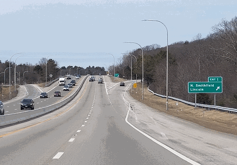
This 2018 photo shows the northbound Woonsocket Industrial Highway (RI 99) at EXIT 1 (Sayless Hill Road) in Lincoln. This is the only numbered exit along RI 99. RI 99 was included in the milepost-based exit numbering sign contract that changed the exit numbers on I-295 in 2017. (Photo by Steve Anderson.)
|
|
|
|
|
|
|
|
|
 |
|
|
|
|
 |
|
|
|
|
|
|
|
|
|
2.9 miles (4.7 kilometers)
1987-1993
|
|
|
|
|
|
|
|
|
 |
|
|
|
|
 |
|
|
|
|
|
EARLY PLANS: In 1959, the Rhode Island Department of Public Works (RIDPW) proposed an expressway along Mendon Road from I-95 in Pawtucket north to downtown Woonsocket. The route was to parallel the RI 146 Expressway. Beyond $535,000 that was allocated for planning during fiscal year 1964, no further plans were developed by the RIDPW for the Mendon Expressway.
|
|
|
|
|
|
|
|
|
|
|
|
|
|
|
|
|
|
|
|
|
Across the border in Massachusetts, state officials announced plans for a "Woonsocket Connector" that was to connect I-495 (Outer Circumferential Highway) near EXIT 18 (MA 126) in Bellingham with downtown Woonsocket. Although the Massachusetts Department of Public Works (MassDPW) did not specify a route in either Massachusetts or Rhode Island, the expressway most likely would have been along routed along MA 126.
EXPRESSWAY SERVICE FOR WOONSOCKET: By the end of the 1960s, Woonsocket had suffered the fate of many other industrial mill towns in New England. The late 19th century French-Canadian enclave and mill town had declined in population, and the development of industrial parks was seen as a last chance to save the city's tax base. To resurrect the fortunes of Woonsocket, and to provide access to the proposed industrial parks, city and state officials sought a modern highway connection to RI 146 and I-295.
In 1970, the Rhode Island Department of Transportation (RIDOT) began studies on a proposed "Industrial Highway" beginning at (or near) the RI 146 / I-295 interchange in Lincoln, and ending near downtown Woonsocket. State officials said that they "could not think of a single factor that would be more important for this area's economic development than a connector linking northern Rhode Island with the Interstate highway system."
The RIDOT developed the following alignments for the Woonsocket Industrial Highway:
ALIGNMENT 1: Beginning at the intersection of RI 146 and RI 104 (Greenville Road), the highway was to continue northeast toward downtown Woonsocket.
ALIGNMENT 2: Beginning at the RI 146 / RI 146A (Old Louisquisset Pike) split, the highway was to continue east to the Cumberland-Woonsocket town line.
|
|
|
|
|
|
|
|
|
|
|
|
ALIGNMENT 3: Beginning at the RI 146 / Sayles Hill Road intersection, the highway was to continue northeast to the Cumberland-Woonsocket town line.
ALIGNMENT 4: Beginning just north of the RI 146 / I-295 interchange, the highway was to continue north, then veer northeast to either downtown Woonsocket (as in alignment 4A) or to the Cumberland-Woonsocket town line (as in alignment 4B).
|
|
|
|
|
|
|
|
|
|
|
|
|
|
|
|
|
|
|
|
|
|
|
|
|
The RIDOT decided upon "alignment 4B" for the proposed highway. Originally proposed as RI 325, the proposed route was re-designated RI 99 during the 1980s.
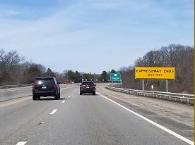
DESIGN AND CONSTRUCTION: In the 1970s, highway planners envisioned a dual-carriageway route with a 65-foot-wide landscaped median, all constructed within a 400-foot-wide right-of-way. The route was to open at the onset as a "super-2," with the second carriageway to be constructed at a later date. Taking advantage of the unspoiled scenery of the Crookfall Brook and Blackstone River valleys (about half the alignment was through undeveloped land), the route was designed with future "passive recreational" development in mind. However, the proposed highway was near the water supply for Woonsocket.
New plans developed during the 1980s saw a number of environmental mitigation measures. The four-lane highway was to be constructed within a reduced right-of-way of only 150 feet, with the remaining right-of-way to be preserved as a "greenway." Opposing traffic flows were to be separated by only a concrete ("Jersey") barrier. Measures were also taken to protect the nearby water supply.
Work began on the Woonsocket Industrial Highway in 1987. The project included the construction of a new high-level bridge across the Blackstone River, and the long-awaited construction of new collector-distributor (C/D) roads along the RI 146 Expressway between the I-295 and RI 99 interchanges. After nearly a quarter-century of planning and construction, RI 99 opened to traffic in November 1993.
According to the RIDOT, the Woonsocket Industrial Highway carries approximately 15,000 vehicles per day (AADT). Owing to its reduced-footprint design, the speed limit on RI 99 is 55 MPH.
|
|
|
|
|
|
|
|
|
 |
|
|
|
|
 |
|
 |
|
|
|
|
|
|
|
|
|
|
|
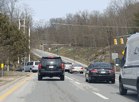
These 2018 photos show the northern terminus of the Woonsocket Industrial Highway (RI 99) at RI 122 (Mendon Road) at the Woonsocket-Cumberland town line. The route continues past the traffic light into Highland Industrial Park, which serves as the headquarters for the CVS Caremark Corporation. (Photos by Steve Anderson.)
|
|
|
|
|
|
|
|
|
 |
|
|
|
 |
|
|
|
|
|
|
|
EXTENSION NORTH TO MASSACHUSETTS: In its 1971 planning report, the RIDOT stated that the northern terminus of the Woonsocket Industrial Highway "must be situated and aligned to accommodate a further extension north en route to an ultimate connection with I-495 in Massachusetts." Such a plan would have been coordinated with the "Woonsocket Connector" plan developed by the MassDPW.
The 1977 RIDOT plan amended the route as follows:
North of the terminus at Mendon Road (RI 122), the Industrial Highway should be extended in the future. This extension would complete the highway as far north as Diamond Hill Road (RI 114). This total facility, from I-295 north to Diamond Hill Road, forms and integral part of the 2000 Rhode Island Transportation Plan.
The development of the Highland Industrial Park (which opened in 1981) seemed to preclude a northerly extension of the expressway. However, the RIDOT reinstated plans for an extension of RI 99 north to RI 114 in their most recent long-range planning study.
|
|
|
|
|
|
|
|
|
|
|
|
|
|
|
|
|
|
|
|
|
|
|
 |
|
|
|
|
|
SOURCES: "A Highway Program for Rhode Island," Rhode Island Department of Public Works (1959); Recommended Highway and Transit Plan, Massachusetts Department of Public Works (1968); "Woonsocket Industrial Highway: Planning Report," Rhode Island Department of Transportation (1971); "Woonsocket Industrial Highway: Draft Environment Impact and Section 4(f) Statement," Rhode Island Department of Transportation and Federal Highway Administration (1977); "Woonsocket Industrial Highway: Final Environment Impact and Section 4(f) Statement," Rhode Island Department of Transportation and Federal Highway Administration (1986); "Interim Ground Transportation Plan for 2010," Rhode Island Department of Transportation (1987); "The Blackstone Valley Found a Future in Its Past" by John Hill, The Providence Journal (11/01/1999); "Leaving Woonsocket" by Ariel Sabar and Scott MacKay, The Providence Journal (10/14/2001); City of Woonsocket; Shawn DeCesari; Michael Kendricks; Michael G. Koerner; Dan Moraseski; Alexander Svirsky
RI 99 shield by Ralph Herman.
Lightpost by Millerbernd Manufacturing Company.
|
|
|
|
|
|
|
|
|
|
|
|
|
|
|
|
 |
|
|
|
|
|
WOONSOCKET INDUSTRIAL HIGHWAY LINK:
RI 99 (David Golub)
|
|
|
|
|
|
|
|
|
|
|
|
|
|
|
|
|
WOONSOCKET INDUSTRIAL HIGHWAY CURRENT TRAFFIC MAPS:
Providence
|
|
|
|
|
|
|
|
|
|
|
|
 |
|
|
|
|
|
WOONSOCKET INDUSTRIAL HIGHWAY VIDEOS:
RI 99 (Dan Murphy)
|
|
|
|
|
|
|
|
|
|
|
 |
|
|
|
|
|
THE EXITS OF METRO BOSTON:
RI 99 exit list by Steve Anderson.
|
|
|
|
|
|
|
|
|
|
|
 |
|
|
|
|
|
|
|
|
|
|
|
|
Site contents © by Eastern Roads. This is not an official site run by a government agency. Recommendations provided on this site are strictly those of the author and contributors, not of any government or corporate entity.
|
|
|
|
|
|
|
|
|
|