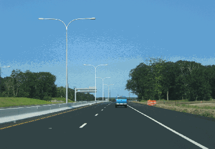
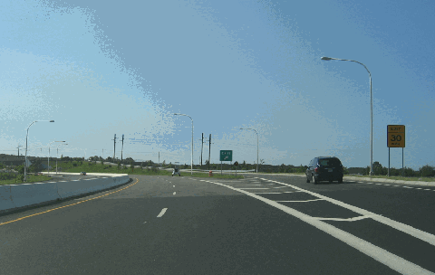
This 2006 photo shows the westbound Quonset Freeway (RI 403) just west of the Post Road (US 1) interchange in North Kingstown. The photo was taken about two weeks after completion of this freeway section. (Photo by Steve Anderson.)
HISTORY OF QUONSET POINT: Quonset Point has had a strong identification with the Navy since before America's entry into World War II. As hostilities brewed across the Atlantic and the Pacific in 1939, the US Navy acquired land for an air base at Quonset Point. In July 1941, five months before the Pearl Harbor attack, the Quonset Point Naval Air Station was commissioned.
In 1942, the Navy acquired additional land for a Naval Construction Battalion Center (NCBC) in Davisville, about two miles west of Quonset Point. Davisville was the home of the "Seabees" (or short for "construction battalions"), who were recruited from the civilian construction trades under the direction of the Navy to build steel "Quonset huts" (which were invented at Davisville) for housing, warehouses, and hospitals. The "Seabees" also built roads, bridges, and airstrips to facilitate transportation.
Activity at the Quonset Point-Davisville complex reached its peak during World War II, though it had smaller peaks during the Korean and Vietnam wars. As America's involvement in Vietnam wound down, the Pentagon shut down the Quonset Point in 1974. The state of Rhode Island took over Quonset Point that year, opening Quonset State Airport (where the Army and Air National Guard maintain operations) and beginning the process of converting complex into an industrial park and municipal golf course. In 1992, the Navy closed the nearby NCBC facility at Davisville.
Today, most of the work done at the Quonset-Davisville Commerce Park is related to defense and electronics firms. The largest firm at the complex - the Electric Boat Division of General Dynamics - still provides submarine hulls for the Navy.
PLANNING THE FREEWAY: By the mid-1980's, approximately 12,000 vehicles per day (AADT) used Route 403 (Davisville Road and Devil's Foot Road) to travel between the Quonset Point-Davisville complex and Colonel Rodman Highway (RI 4). Studies conducted by the Rhode Island Department of Transportation (RIDOT) found that volume on RI 403 would more than double to 25,000 vehicles by 2005. Given the dangerous curves and 25 MPH speed limit on sections of existing RI 403 - particularly through the Old Davisville Historic District - the RIDOT began studies on improving the route.
The RIDOT 1987 draft environmental impact statement devised the following alternatives for RI 403:
UPGRADE ALONG EXISTING RI 403: This alternative would have widened the existing Davisville Road and Devil's Foot Road to four lanes (from two lanes). The proposed $16 million widening project, which was to have taken place between RI 4 and Commerce Park Road, was found to have potential adverse effects on the Old Davisville Historic District. It also was found to be less effective in relieving congestion (particularly during the morning rush) than any of the freeway alternatives. For these reasons, the RIDOT dropped the upgrade alternative.
FREEWAY ALTERNATIVE 2: Beginning at a new "trumpet interchange" on RI 4 just north of the existing EXIT 7, the proposed four-lane Quonset Freeway was planned to cross Frenchtown Road (RI 402) and the Hunt River on a single-span bridge. Veering from the east to the south, the freeway was to cross over the Amtrak-Northeast Corridor tracks, then parallel the tracks before traveling under old RI 403. Veering southeast, the expressway was to parallel a railroad spur line to Quonset Point. There was to be a diamond interchange at West Davisville Road and a partial cloverleaf interchange at Post Road (US 1). The expressway was to end at the intersection of Roger Williams Way and Commerce Park Drive. Its estimated cost was $27 million.
FREEWAY ALTERNATIVE 4: Much of the route of "alternative 4" was similar to that for "alternative 2" except that (1) EXIT 7 on RI 4 (Colonel Rodman Highway) was to be rebuilt with more complex connections to RI 403 (Quonset Freeway) and RI 402 (Frenchtown Road); and (2) the terminus Davisville Road was to have been relocated on RI 402 east of the Narragansett Electric right-of-way. Although its $23 million price tag was less than that of "alternative 4," "alternative 2" was dropped because of its more adverse environment effects on the Hunt River and Frenchtown Brook.
In 1996, the RIDOT and the Federal Highway Administration (FHWA) reached a record of decision to build "alternative 2" following approval by the Army Corps of Engineers and the US Environmental Protection Agency (EPA). The cost of the project - which by then had risen to $56 million - was to be 80 percent financed by the Federal government. Late attempts by environmental groups to stop the Quonset Freeway project were not successful.
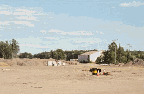
This 2002 photo shows early construction work underway on the Quonset Freeway (RI 403) in the area of West Davisville Road interchange in North Kingstown. A full diamond interchange was planned here, but only two ramps were built initially. (Photo by Steve Anderson.)
BUILDING THE QUONSET FREEWAY: Following the example set by the Woonsocket Industrial Highway (RI 99), which was built during the late 1980's and early 1990's, the RIDOT planned the Quonset Freeway within a narrow right-of-way (200 feet wide) with the remaining right-of-way to be preserved as a "greenway." Opposing traffic flows on the four-lane freeway were to be separated by a concrete ("Jersey") barrier. However, the original design had only 10-foot-wide right shoulders; as constructed, it was built with 12-foot-wide right shoulders to comply with new Federal guidelines. (The four-foot-wide left shoulders were not changed). It has a design capacity of 30,000 vehicles per day (AADT).
Construction of the Quonset Freeway began in 2000 with right-of-way acquisition and preliminary excavation work. The freeway required the removal of eight residences and five businesses.
During Phase 1 of construction, which extends from the eastern terminus of the expressway at Commerce Park Drive west to School Street, the RIDOT maintained traffic flow on Devil's Foot Road while it created a new terminus for that road at the intersection of US 1 and Newcomb Road. The RIDOT proceeded with plans to build a full interchange at US 1, but only built a partial diamond at West Davisville Road in Phase 1 (exit from eastbound RI 403 and entrance to westbound RI 403). A temporary connection between the freeway and Devil's Foot Road was built just east of the Amtrak bridge on existing RI 403.
The $70 million Phase 1 of the Quonset Freeway was completed on June 22, 2006, in time for the Rhode Island Air Show at Quonset State Airport. The speed limit on the "Phase 1" section is 45 MPH.
Construction of Phase 2 of "Relocated Route 403" began in March 2004 at the site of the "trumpet" interchange with RI 4. New bridges over RI 402 and the Amtrak right-of-way are included in Phase 2, as is the demolition of the existing bridge from southbound RI 4 to eastbound Davisville Road (this interchange movement is being replaced with the movement to the new eastbound Quonset Freeway). The $100 million Phase 2 was completed on October 22, 2008, about 14 months earlier than scheduled originally. The speed limit on the "Phase 2" section is 50 MPH.
Four years after the photo above was taken, this 2006 photo shows the completed West Davisville Road interchange on the Quonset Freeway (RI 403). Note that the exits on RI 403 are not numbered. (Photo by Steve Anderson.)
SOURCES: "Improved Access to Quonset Point / Davisville from Route 4: Draft Environmental Impact Statement," Rhode Island Department of Transportation and Federal Highway Administration (1987); "Improved Access to Quonset Point / Davisville from Route 4: Final Environmental Impact Statement," Rhode Island Department of Transportation and Federal Highway Administration (1995); "State Moving Ahead on Connecting Highway" by Chris Poon, The Providence Journal (10/14/1997); "Relocated Route 403 Construction Project," Rhode Island Department of Transportation (2003); "Trouble Ahead: Work for Quonset Connector Moves to Route 4" by Arthur Gregg Sulzberger, The Providence Journal (5/04/2005); Quonset Development Corporation; Steve Alpert; Shawn DeCesari.
RI 403 shield by Barry L Camp. Lightposts by Millerbernd Manufacturing Company.