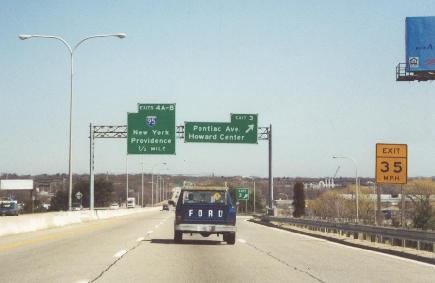
This 2001 photo shows the eastbound RI 37 Expressway approaching EXIT 3 (Pontiac Avenue) in Warwick. An early alignment for I-895 once was planned to extend the RI 37 corridor across Upper Narragansett Bay. (Photo by Steve Anderson.)
THE LINCOLN AVENUE FREEWAY: The RI 37 Expressway first appeared on a 1956 map of proposed freeways published by the Rhode Island Department of Public Works (RIDPW) in its report, "Rhode Island Roads." In its original incarnation, the expressway was to run from RI 116 (North Road) in Hope east to RI 117 (Warwick Avenue) in Warwick. It was to connect to the proposed I-295 (then known as RI 5) in Cranston and the proposed I-95 (then planned for US 1) in Warwick.
By 1959, the RIDPW amended the route of the RI 37 Expressway - which was named in a planning report as the "Lincoln Avenue Freeway" after a local street in Warwick that was to serve as an approximate routing - from the proposed I-295 in Cranston to a proposed southerly extension of the Huntington Expressway (RI 10) in Warwick. Through proposed links to the north and west, the RI 37 Expressway was to provide access to T.F. Green Airport for Connecticut and Massachusetts. Work on the $7 million expressway, which was to have been built through mostly undeveloped land, was scheduled to begin in 1960 with completion slated for 1964.
As state officials focused attention on the completion of I-95 and I-195, work on RI 37 was delayed until 1963. The four-lane RI 37 Expressway was not completed until 1969. In the area of EXIT 3 (Pontiac Avenue) in Warwick, the expressway was built over part of a 3.4-acre cemetery used to bury residents of the nearby State Farm, a complex that housed an almshouse, mental asylum and prison between 1875 and 1916.
According to the Rhode Island Department of Transportation (RIDOT), the RI 37 Expressway carries approximately 30,000 vehicles per day (AADT). The 50 MPH speed limit on the expressway reflects 1960's urban freeway design standards of tight interchange spacing and lack of shoulders on some overpasses.
TANKER CRASH SPARKS FEAR: On July 20, 2000, a truck carrying about 10,000 gallons of jet fuel overturned and burned for several hours on the ramp leading to RI 37 eastbound from I-95 southbound. The resulting fire damaged about 400 feet of roadway, including the overpass carrying the westbound lanes of RI 37, and fuel spilled into the nearby Pawtuxet River. Although jet fuel burns hotter than conventional fuel, it tends to evaporate faster, limiting the damage. As a result, the westbound RI 37 bridge over the eastbound ramp reopened one week later.
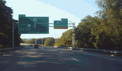
This 2005 photo shows the westbound RI 37 Expressway at EXIT 4 (I-95 / North-South Expressway) in Warwick. (Photo by Douglas Kerr, www.gribblenation.com.)
EXTENDING RI 37 ACROSS NARRAGANSETT BAY: In 1966, officials in Rhode Island and Massachusetts reiterated plans for a southern Providence bypass. The bypass, which together with I-295 was to form a full beltway around Providence, was composed of the following components:
The RI 37 Expressway was to continue east of US 1 in Warwick across Narragansett Bay through Barrington and Warren, then veer north into Massachusetts to I-195 (EXIT 2) in Swansea.
The proposed route was to be extended north past I-195 through the communities of Swansea, Rehoboth, and Attleboro to the I-95 / I-295 interchange in Attleboro.
Officials from both states submitted the route - which they proposed as an extension of I-295 - to the Federal Highway Administration (FHWA) in 1968, hoping the route would be included as part of the additional 1,500 new Interstate miles authorized nationwide. The FHWA approved the route in 1969, but provided a new designation: I-895. By connecting to I-295 in Massachusetts, the new I-895 was to complete the beltway around Providence to the east and south. The original route of I-895 was to extend approximately 15.8 miles (costing $47 million) in Massachusetts, and approximately 12.1 miles (costing $115 million) in Rhode Island.
From the I-895 submission report:
The 28.0-mile-long highway would form a circumferential route around the southern and eastern fringes of the Providence-Pawtucket Urbanized Area, complementing I-295 which performs the same function to the west and north of this major metropolitan community. It would provide urgently needed relief for I-95 and I-195 within the core of this urban area. It also will permit long-distance travelers between New York and Connecticut, and the Fall River-New Bedford metropolitan area and Cape Cod, to bypass this congested urban core.
Scheduled for completion by 1975, the proposed four-to-six-lane I-895 was designed to carry approximately 60,000 vehicles per day (AADT) between I-95 in Warwick and I-195 in Swansea. However, strident opposition in the densely populated communities of Warren and Barrington, as well as concerns that a high-level fixed bridge across Upper Narragansett Bay would affect air traffic at nearby T.F. Green Airport, stopped the initial I-895 proposal.
A WESTERLY EXTENSION TO CONNECTICUT: In 1981, the RIDOT revived dormant plans for a westerly extension of the RI 37 Expressway. Offered by the RIDOT as an alternate route for the proposed I-84 extension between East Hartford and Providence, the RI 37 alternative largely avoided potential damage to Scituate Reservoir (which ultimately thwarted the original I-84 routing). However, even this plan met with opposition from groups such as "Stop I-84."
The RIDOT abandoned further study of an I-84 route to Providence after finding that there was no suitable alternative to the previously recommended route in the area of the Scituate Reservoir. It officially canceled its portion of I-84 on May 5, 1982. In November 1983, the Connecticut Department of Transportation (ConnDOT) traded in the Interstate highway mileage for the proposed I-84 east of the existing I-384 terminus in Bolton.
MORE RECENT PLANS TO HOXSIE: In its 1992 report "Transportation 2010," the RIDOT proposed an easterly extension of the RI 37 Expressway east through Warwick. The state offered two alternatives:
ALTERNATIVE A: RI 37 would continue east of US 1 for about three-quarters of a mile, veering southeast toward Airport Road in the area of Commerce Drive. However, the RIDOT dropped this route from consideration because the terminus interfered with the approach to T.F. Green Airport.
ALTERNATIVE B: RI 37 would continue east of US 1 for about 1.5 miles. There would be a grade-separated interchange at Warwick Avenue (RI 117) north of Spring Green Pond and Hoxsie Four Corners before the expressway veers southeast toward West Shore Road. A variation on this alternative that would shorten the expressway to Hoxsie Four Corners - eliminating the grade-separated interchange at Warwick Avenue and creating a "Hoxsie Five Corners" - was dropped after traffic studies found that confusion (and thus accidents) would increase.
Since 2000, the RIDOT has redirected much of its focus on other projects such as the I-195 realignment, the RI 10 / US 6 interchange reconstruction, and the new Quonset Freeway (RI 403). The RI 37 Expressway extension to West Shore Road has gained additional support from the business community, but residential opposition remains as strong as ever.
SOURCES: "Rhode Island Roads," Rhode Island Department of Public Works (1956); "A Highway Program for Rhode Island," Rhode Island Department of Public Works (1959); "Transportation 2010: Ground Transportation Plan," Rhode Island Department of Transportation (1992); "Interstates: Life in the Fast Lane, Landmarks in the Dust" by Tom Carbone, The Providence Journal (8/30/1999); "Driver of Tanker Truck Charged; Tipover Caused Major Jet Fuel Spill Last Summer," Rhode Island Department of Environmental Management (3/12/2001); "T.F. Green Airport: Supplemental Scoping Process Report," Federal Aviation Administration and Rhode Island Airport Corporation; "Runway Expansion: A Little Common Sense" by Colby Cameron, The Cranston Herald (4/20/2006); "A Year Ends With Winners, Losers" by Talia Buford, The Providence Journal (12/29/2006); Shawn DeCesari; Michael Kendricks; Dan Moraseski; Chris O'Leary; Scott Oglesby; Alexander Svirsky.
RI 37 shield by Barry L. Camp. I-895 and I-84 shields by Ralph Herman. Lightposts by Millerbernd Manufacturing Company.