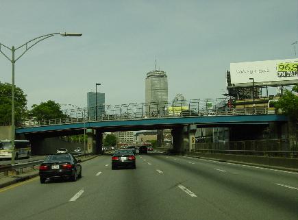
This 2001 photo shows the southbound East Shore Expressway approaching the exit for Pawtucket Avenue. The expressway picks up the RI 114 designation at this exit and ends shortly thereafter. (Photo by Steve Anderson.)
LINKING I-195 TO BRISTOL COUNTY: Originally part of statewide plans for a freeway connecting East Providence with the Mount Hope Bridge, the East Shore Expressway exists only as a mile-long spur off I-195 (East Providence Expressway). For much of its length, the expressway spur does not have a signed designation, but does pick up the RI 114 designation for the last quarter-mile.
Construction of the East Shore Expressway began in 1957 as part of the I-195 contract. The four-lane route, which has exits at I-195 (a partial interchange from eastbound I-195 and to westbound I-195), US 6 (Warren Avenue), and RI 114 (Wampanoag Trail), was completed on December 15, 1959.
At the time of completion and for about eight months thereafter, all eastbound I-195 exited onto the East Shore Expressway. I-195 was extended east of EXIT 7 (RI 114 / East Shore Expressway) in August 1960.
According to the Rhode Island Department of Transportation (RIDOT), the East Shore Expressway carries approximately 30,000 vehicles per day (AADT). In 2006, the Rhode Island General Assembly asked the RIDOT to study the area where the East Shore Expressway transitions to Wampanoag Trail, where there have been several fatal accidents in recent years.
A LINK TO THE MOUNT HOPE BRIDGE: In 1955, the Rhode Island Department of Public Works (RIDPW) commissioned a study for a proposed East Shore Expressway through East Providence and Bristol County linking the future I-195 with the Mount Hope Bridge and Aquidneck Island. The expressway was to relieve congestion on the existing RI 114 and RI 136. These two-lane routes were built for local traffic and serve as main streets in Bristol, Warren, and Barrington, but increasingly served through traffic between Providence and Newport.
The 1955 report prepared by Wilbur Smith and Associates proposed the following route for the four-lane expressway:
Beginning at I-195, the East Shore Expressway was to head directly south past existing RI 114 (Wampanoag Trail), not curve to the east as it does today. There were to be diamond interchanges at Wampanoag Trail and Forbes Street in East Providence.
Continuing south into Bristol County, the expressway was to have a diamond interchange with RI 103 (County Road) in Barrington. It was to bisect Haines Memorial State Park before veering east along the New York, New Haven, and Hartford Railroad right-of-way near Middle Highway.
There was to have been an interchange with RI 103 / existing RI 114 just north of Rumstick Road. New bridges were to have been built over the Barrington and Warren rivers.
Continuing along the railroad right-of-way, the expressway was to veer south again in Warren; the expressway may have been routed through North Burial Ground, a cemetery dating back to 1773.
At Nobert Street, a spur route was to branch off the expressway and continue along the railroad right-of-way to RI 114 (Main Street) in downtown Warren. The mainline expressway was to continue southeast through Albert G. Jamiel Memorial Highway before veering south at Franklin Street.
The $20 million East Shore Expressway was scheduled for completion by 1960. However, as state funding priorities shifted to the completion of I-95 and I-195, the East Shore Expressway remained on the drawing board.
A SECOND CHANCE: In 1966, with I-95 and I-195 nearing completion in the immediate Providence metropolitan area, the RIDPW turned its attention again to the East Shore Expressway. The route of the expressway through Bristol County was roughly the same as that in the 1955 plan, but instead of veering northwest toward East Providence, the expressway was to cross into Massachusetts as the "East Shore Connector" toward I-195 in Swansea (near the existing EXIT 2).
The 8.2-mile-long expressway through Bristol County was to cost $14 million, not including the cost of a new Mount Hope Bridge and adjacent approaches. The four-lane expressway, which had a 55 MPH design speed, was to be built with the provision for two additional lanes in the center median in anticipation of the 45,000 vehicles per day (AADT) it was to carry by 1990. Provisions were to be made for connections for the proposed Upper Narragansett Bay Connector (RI 37 Expressway) and an extension of the East Shore Expressway north of I-195 toward I-95 in Attleboro.
The East Shore Expressway received its biggest boost in 1969 when the Federal Highway Administration (FHWA) approved the northernmost section and a connecting section (not part of the East Shore project) heading west over Upper Narragansett Bay as part of I-895. When the Upper Narragansett Bay bridge was cancelled, the I-895 designation was approved for the entire length of the East Shore Expressway as part of a 40.8-mile-long southern bypass of Providence.
The RIDOT initiated corridor location and environmental impact studies in November 1975. Following the December 1978 publication of a draft environmental impact statement, the RIDOT and Massachusetts Department of Public Works (MassDPW) held four public hearings on the route during the summer of 1979.
After years of environmental studies and contentious public hearings, the RIDOT and the MassDPW requested deleting I-895 from the Interstate highway system in December 1979, effectively killing the East Shore Expressway. However, it was not until December 30, 1982 that the FHWA formally removed the I-895 designation through Massachusetts and Rhode Island.
SOURCES: "Traffic and Highway Study for East Providence, Barrington, Warren and Bristol, Rhode Island," Wilbur Smith and Associates (1955); "Rhode Island Roads," Rhode Island Department of Public Works (1956); "A Highway Program for Rhode Island," Rhode Island Department of Public Works (1959); "East Shore Expressway," Rhode Island Department of Public Works (1966); "Proposed Interstate System Adjustment," Rhode Island Department of Public Works and Massachusetts Department of Public Works (1968); "The Interstate Highway System in Rhode Island: A Force for Change in Rhode Island" by Dieter Hammerschlag, Brian K. Barber and J. Michael Everett, University of Rhode Island (1976); "DOT To Discuss East Shore Study on Traffic Safety," The Providence Journal (3/09/2006); Michael Kendricks; Deby Jecoy Nunes; Alexander Svirsky.
RI 114 shield by Barry L. Camp. I-895 shield by Ralph Herman. Lightposts by Millerbernd Manufacturing Company.