
|
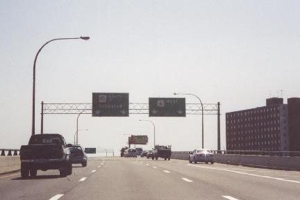
This 2001 photo shows the southbound Huntington Expressway (RI 10) at the split for the Dennis J. Roberts Expressway (US 6) in Providence. A major reconstruction of this interchange is planned after 2010. (Photo by Steve Anderson.) |
||
|
RHODE ISLAND'S FIRST EXPRESSWAY: As Rhode Island officials mapped out an arterial network during the late 1940's and early 1950's, they proposed an "inner loop" bypass of the North-South Expressway (I-95). Plans for the inner loop, which eventually became the "Huntington Avenue Expressway" (and later the "Huntington Expressway"), was submitted to the Federal government for inclusion in the 41,000-mile Interstate highway network then under development. The Federal government rejected this proposal. |
||
|
Nevertheless, the Rhode Island Department of Public Works (RIDPW) commenced work on the Huntington Expressway (RI 10) in 1950 upon approval of a $20 million bond issue for various road improvements around the state. The first section of expressway, a 0.7-mile-long stretch from Union Avenue north to Harris Avenue, opened to traffic in 1953. The isolated stretch of expressway, which paralleled the New York, New Haven, and Hartford Railroad (now Amtrak), was intended as a bypass of the Olneyville section of Providence. It included a short westerly spur to Plainfield Street (RI 14) that eventually became the Dennis J. Roberts Expressway (US 6). |
||
|
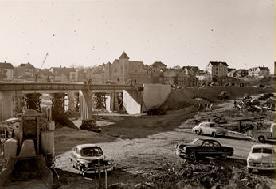
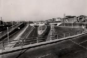
LEFT: This 1951 photo shows construction of the interchange between the Huntington Expressway (RI 10) and the Dennis J. Roberts Expressway (US 6) in the Olneyville section of Providence. RIGHT: The nearly completed Olneyville interchange is shown in this 1952 photo. (Photos by Rhode Island Department of Transportation, from the Route 6-Route 10 Interchange Reconstruction Project web site.) |
||
|
COMPLETION DELAYED BY FOUR DECADES: In 1972, the northern terminus of the expressway was moved north of the Harris Avenue ramps to a modified trumpet interchange at Dean Street. The "temporary" northbound ramp from RI 10 to Harris Avenue - which had been in service for nearly 20 years - was abandoned. |
||
|
Final completion of the Huntington Expressway awaited city and state plans for the Civic Center interchange with I-95, which included a redevelopment of downtown Providence and the relocation of the Amtrak-Northeast Corridor railroad. The Rhode Island Department of Transportation (RIDOT) studied a number of plans, from simple flyover ramps connecting to local streets, to complex multi-level interchanges. A series of studies, most notably the 1979 Capital Center Project Development Plan and the 1983 Providence Waterfront Study, had the proposed US 6 / RI 10 Expressway extension to I-95, the Civic Center interchange, and the "6-10 Connector" extension to Memorial Boulevard as key components of downtown's revival. The comprehensive proposal, whose estimated $169 million cost was to be paid with Federal, state, and local funds, was adopted in 1984. |
||
|
According to the RIDOT, the four-lane Huntington Expressway carries approximately 30,000 vehicles per day south of US 6, and approximately 50,000 vehicles per day along the "6-10 Connector" section between the Olneyville interchange and downtown Providence. Because of its pre-Interstate era design along much of the route, which is characterized by substandard geometry, weaving sections, and short acceleration-deceleration ramps, the speed limit on the expressway is 50 MPH, except for near the Civic Center interchange (where the speed limit drops to 35 MPH). |
||


|
ANOTHER ATTEMPT AT AN INTERSTATE DESIGNATION: During the 1970's and early 1980's, an extension of Interstate 84 from Hartford east to Providence was an active proposal. The proposed I-84 was to enter Providence via the Dennis J. Roberts Expressway (now US 6), and veer north along the then-(mostly) unbuilt section of the Huntington Expressway from US 6 east to I-95 and downtown Providence. According to one planning map, the existing section of RI 10 south of US 6 was to receive the I-184 designation. The Federal Highway Administration (FHWA) never approved the I-184 designation. In 1982, the RIDOT withdrew its I-84 proposal. |
||
|
CHANGES FOR THE OLNEYVILLE INTERCHANGE: The initial section of the Huntington Expressway in the area of the Olneyville interchange with US 6 (Dennis J. Roberts Expressway) was determined by the RIDOT to be in dire need of replacement. In addition to its substandard design attributes, the modified "trumpet" interchange lacked a ramp from RI 10 northbound to US 6 westbound. A series of minor bridge rehabilitation and repaving projects between 1997 and 2004 were carried out by the RIDOT as interim measures. |
||
|
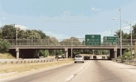
This 2002 photo shows the southbound Huntington Expressway (RI 10) at Reservoir Avenue (RI 2) in Cranston. This interchange served as the southern terminus of RI 10 from the late 1950's through the mid-1960's. (Photo by Steve Anderson.) |
||

|
EXTENDING SOUTH TO WARWICK: The state's 1959 comprehensive highway plan had the Huntington Expressway (RI 10) extending south of Park Avenue (RI 12) toward Oakland Beach. Construction of the expressway, which was to be extended six miles south along Warwick Avenue (RI 117) and Oakland Beach Avenue (RI 117A), was scheduled to begin after 1965. It was to have an interchange with the RI 37 Expressway near the intersection of RI 117 and Airport Road in Warwick. |
||
|
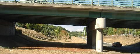
This 2007 photo shows the southern terminus of the Huntington Expressway (RI 10) at Park Avenue (RI 12) in Cranston looking north. The unused right-of-way in the left of this photo would have been for the southbound lanes of RI 10 for a potential extension south to RI 117 in Warwick. (Photo by Steve Alpert.) |
||


|
THE "82 CONNECTOR" AND MORE: The "6-10 Connector" section of the Huntington Expressway should be re-designated I-82 as part of the proposed Hartford-to-Providence Interstate highway. The existing section of RI 10 south of US 6 should be re-designated I-282. Both designations would be applied given upgrades to Interstate standards. |
||


|
SOURCES: "Rhode Island Roads," Rhode Island Department of Public Works (1956); "Two Road Links to Open," The New York Times (11/22/1959); "A Highway Program for Rhode Island," Rhode Island Department of Public Works (1959); "First Two Ramps at Civic Center Interchange Will Open Next Week," The Providence Journal (7/08/1988); "Transportation 2010: Ground Transportation Plan," Rhode Island Department of Transportation (1992); Providence River Relocation, Bruner Foundation (2003); "Route 6-10 Interchange," Rhode Island Department of Transportation (2006); Steve Alpert; Shawn DeCesari; Michael Kendricks; Dan Moraseski; Scott Oglesby; Chris O'Leary; Frances Segerson; Alexander Svirsky. |
||


|
HUNTINGTON EXPRESSWAY LINKS: |
||
|
HUNTINGTON EXPRESWAY CURRENT CONDITIONS: |
||

|
THE EXITS OF METRO BOSTON: |
||
|
VIEW OR SUBMIT YOUR RATING TO RATETHEROADS.COM |
||

|
Back to The Roads of Metro Boston home page. |
||
|
Site contents © by Eastern Roads. This is not an official site run by a government agency. Recommendations provided on this site are strictly those of the author and contributors, not of any government or corporate entity. |
||