
|
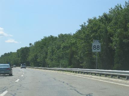
This 2008 photo shows the southbound MA 88 (Horseneck Beach Connector) approaching the exit for US 6 (State Road) in Westport. MA 88 narrows from four to two lanes south of US 6, although the concrete ("Jersey") barrier continues south to the intersection with Old Country Road. (Photo by Steve Anderson.) |
||
|
CONNECTING I-195 WITH THE BEACH: The Horseneck Beach Connector was designed in the 1950s to connect the then-proposed "Cape Cod Expressway"--which eventually became known as I-195--with Horseneck Beach State Reservation. The state acquired land for the park in 1955 after three hurricanes in 1938, 1944, and 1954 devastated the popular Horseneck Beach summer community. |
||
|
It was only in the immediate northern terminus of MA 88--near the I-195 and US 6 interchanges--that the Horseneck Beach Connector was built out to its intended four-lane freeway design. There is a grade-separated diamond interchange with MA 177 on the "super-2" section of MA 88, but there are five signaled intersections with Briggs Road, Old Country Road, Hix Bridge Road, and Drift Road. A parking area was built for southbound vehicles between Old Country Road and Hix Bridge Road. The highway widens back to four lanes over the Fontaine Bridge before ending at a rotary near Horseneck Beach State Reservation. |
||
|
The speed limit on MA 88 is 55 MPH from the Fontaine Bridge north to I-195, but it is reduced to 45 MPH in the immediate area of the signaled intersections and 30 MPH on the Fontaine Bridge and its southern approach. |
||
|
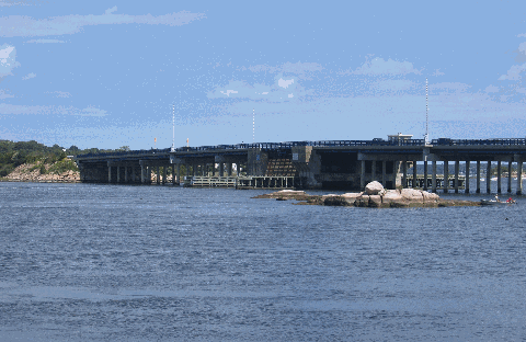
This 2010 photo shows MA 88 crossing over the East Branch of the Westport River. The Fontaine Bridge, which was built in the late 1950s, replaced an old wooden bridge on the site. In 1993, the bridge was named after Normand Fontaine, one of two Westport residents killed in combat in the Vietnam War. (Photo by Steve Anderson.) |
||

|
REBUILD MA 88 AS AN EXPRESSWAY: The MA 88 Connector should be rebuilt as a full four-lane freeway from US 6 south to the Fontaine Bridge. Interchanges should be built at Drift Road, Hix Bridge Road, and Old Country Road, while emergency ramps should be built at Briggs Road to serve a nearby fire station. |
||
|
EXIT 1A: John Reed Road / Horseneck Beach State Reservation |
||

|
SOURCES: "A Report of Progress," Massachusetts Department of Public Works (1962); "The Massachusetts Highway Story (1949-1969)," Massachusetts Department of Public Works (1969); "Fatality-Free Route 88 Stands As Testament to Perseverance," The Standard-Times (7/28/1998); Westport by Westport Historical Society, Arcadia Press (2008); Massachusetts Department of Transportation; The General Court of Massachusetts. |
||
|
HORSENECK BEACH CONNECTOR LINKS: |
||
|
HORSENECK BEACH CONNECTOR VIDEO LINK: |
||
|
HORSENECK BEACH CONNECTOR CURRENT CONDITIONS: |
||

|
OFF-SITE EXIT LISTINGS: |
||
|
VIEW OR SUBMIT YOUR RATING TO RATETHEROADS.COM: |
||

|
Back to The Roads of Metro Boston home page. |
||
|
Site contents © by Eastern Roads. This is not an official site run by a government agency. Recommendations provided on this site are strictly those of the author and contributors, not of any government or corporate entity. |
||