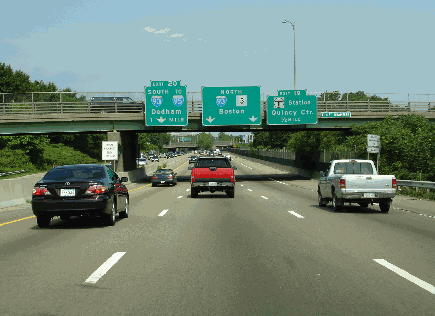
This 2005 photo shows the northbound Pilgrims Highway (MA 3) approaching EXIT 19 (Quincy Center) in Braintree. These signs since have been replaced. (Photo by Jim K. Georges.)
TO THE SOUTH SHORE AND CAPE COD: In 1947, the Massachusetts Department of Public Works (MassDPW) announced plans for a "Relocated Route 3" that was to handle traffic from the Boston area through the South Shore suburbs to Cape Cod. The north-south highway, part of a comprehensive statewide expressway plan, also was incorporated into the Master Highway Plan for the Boston Metropolitan Area, which the MassDPW released one year later.
Work on the 42.5-mile-long expressway began in 1948, and two years later, the first section of the "Relocated Route 3," stretching six miles through the Plymouth area, opened to traffic. This section included a two-mile-long spur, the "Plimoth Plantation Highway," that initially served as the southern terminus of the controlled-access MA 3.
Little by little, the expressway - known locally as "Route 3 South," and renamed the "Pilgrims Highway" by Governor Furcolo in 1960 - was extended to the north and south. By the late 1950's, new expressway sections opened to provide connections to the Southeast Expressway (I-93, US 1 and MA 3) and the Yankee Division Highway (I-93, US 1 and former MA 128) to the north, and to the Sagamore Bridge (US 6) to the south. In 1963, the section of expressway between Duxbury and Hanover opened to traffic.
South of Kingston, the old MA 3 was re-designated MA 3A. From Kingston north to Quincy, the old MA 3 received the MA 53 designation.
COPING WITH CONGESTION: As early as 1968, regional officials in the Boston area and southeastern Massachusetts, as well as officials from the MassDPW, recommended expanding MA 3 to six lanes from EXIT 16 (MA 18) in Weymouth south to the Sagamore Circle. The expansion was deemed necessary to deal not only with commuter traffic, but also with recreational traffic. The Recommended Highway and Transit Plan budgeted $19 million for widening the expressway from EXIT 16 south to EXIT 11 (MA 14) in Duxbury. However, the only widening that took place was the construction of a third southbound lane from EXIT 16 to one-half mile before EXIT 15 (Derby Street) in South Weymouth.
During the late 1980's, the MassDPW conducted studies on improving traffic flow along the MA 3 corridor through the South Shore. Various measures, including constructing a third lane in each direction from EXIT 16 (MA 18) south to EXIT 11 (MA 14), and extending commuter rail service, were studied. As an interim measure, the MassDPW implemented a shoulder lane for use during rush hour from EXIT 16 to just south of EXIT 13 (MA 53 and MA 123) in Hanover.
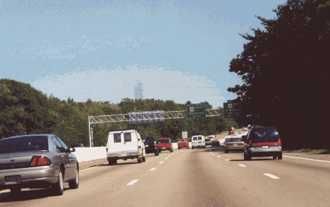
This 2000 photo shows the southbound Pilgrims Highway (MA 3) approaching EXIT 16 (MA 18) in Weymouth. South of this point, the expressway narrows from three lanes to two lanes in each direction. (Photo by Steve Anderson.)
ROADWAY LAYOUTS AND TRAFFIC COUNTS: Along the length of MA 3, the speed limit is 60 MPH. The different sections of the Pilgrims Highway are described as follows:
Sagamore Circle (US 6) in Sagamore to EXIT 4 (Plimoth Plantation Highway) in Plymouth: This four-lane section, which was constructed between 1955 and 1957, carries approximately 35,000 vehicles per day (AADT). A traffic circle with US 6 marks the southern end of this section. There is no access to EXIT 4 northbound.
EXIT 4 (Plimoth Plantation Highway) in Plymouth to EXIT 9 (MA 3A) in Kingston: This four-lane section was constructed between 1948 and 1951. The first section to be completed, it carries approximately 50,000 vehicles per day. Construction of this section included a two-mile-long, "super-2" limited-access spur, the Plimoth Plantation Highway, which serves nearby Plimoth Plantation. This spur is only accessible from the southbound lanes of MA 3 (from which there is a left-hand exit).
EXIT 9 (MA 3A) in Kingston to just north of EXIT 10 (MA 3A and MA 53) in Duxbury: This four-lane section, which was constructed between 1954 and 1956, carries approximately 60,000 vehicles per day. When it was built, the section actually ended at a temporary interchange located just north of EXIT 10, at Elm Street in Duxbury.
North of EXIT 10 (MA 3A and MA 53) in Duxbury to EXIT 13 (MA 53 and MA 123) in Hanover: This four-lane section was constructed between 1960 and 1963. The final section to be completed, it carries approximately 75,000 vehicles per day. A new bridge was constructed at Elm Street in Duxbury, where the highway previously ended, and the temporary interchange was abandoned.
EXIT 13 (MA 53) in Hanover to EXIT 14 (MA 228) in Hingham: This four-lane section, which was constructed between 1954 and 1956, carries approximately 100,000 vehicles per day. Since 1985, the state has permitted the use of the right shoulder as a travel lane through this area.
EXIT 14 (MA 228) in Hingham to EXIT 20 (I-93 and US 1/ Southeast Expressway and Yankee Division Highway) in Braintree: Built from 1956 to 1959, this section was originally constructed as a six-lane sub-section from EXIT 20 (I-93) south to EXIT 16 (MA 18), and as a four-lane sub-section from EXIT 16 south to EXIT 14. Until 1963, most of this section (from EXIT 15 to EXIT 20) was co-signed with MA 128. In 1980, a third southbound lane was added from EXIT 16 to just north of EXIT 15 (Derby Street) in Hingham. Since 1985, the MassDPW has permitted the use of the right shoulder as a travel lane south of EXIT 16. A "Y"-interchange with I-93 marks the northern end of this section. This section carries approximately 125,000 vehicles per day.
CURRENT AND FUTURE IMPROVEMENTS: The Massachusetts Highway Department (MHD) has scheduled the following improvements on Pilgrims Highway:
During 2001 and 2002, the MHD resurfaced the Pilgrims Highway from EXIT 11 (MA 14) in Duxbury north to the Hingham-Weymouth town line. The $6 million project, which included the removal of rumble strips between EXIT 12 (MA 139) in Pembroke and EXIT 13 (MA 53 and MA 123) in Hanover, was completed in late 2003. According to the MHD, this section of MA 3 is expected to carry approximately 115,000 vehicles per day by 2010.
Also during the 2001-2002 time frame, the MHD converted the existing EXIT 7, a partial-cloverleaf interchange serving local traffic (Cherry Street and Nicks Rock Road) in Plymouth into a high-speed "trumpet" interchange serving the new US 44 Expressway. The new ramps opened to traffic in July 2004.
Work began in late 2003 on the construction of the overpass at EXIT 9 (MA 3A) in Kingston. The work on rebuilding the superstructure and substructure was completed in 2004.
In January 2005, the state began work on converting the Sagamore Circle - the southern terminus of Pilgrims Highway and where MA 3 meets US 6 - into a grade-separated interchange. The $58 million interchange project, which was intended to relieve congestion between the South Shore and the Sagamore Bridge, replaced a 1930's-era rotary that was designed to handle a maximum of 40,000 vehicles per day. The new interchange comprises a new four-lane overpass for through traffic between MA 3 and US 6, as well as new entrance and exit ramps for MA 3A and US 6. It also relocated a nearby park-and-ride lot, a MassDOT district maintenance facility, and the Bourne fire station. The project was completed in November 2006. Officials estimate that the improvement will save $23 million annually by expediting goods shipments to and from Cape Cod.
MassDOT is considering a long-term project to expand MA 3 to eight lanes from EXIT 20 (I-93) south to EXIT 16 (MA 18), and to six lanes from EXIT 16 south to EXIT 10 (MA 3A and MA 53). Officials are studying the $120 million "add-a-lane" project.
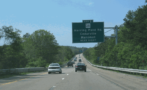
This 2006 photo shows the northbound Pilgrims Highway (MA 3) approaching EXIT 2 (MA 3A) in Plymouth. The signs in this area date back to the 1970s and since have been replaced. (Photo by Steve Anderson.)
Upon completion of projects designed to bring the entire length of the route to Interstate standards, the Pilgrims Highway should be re-designated I-93. As part of the improvement, the expressway should be expanded to six lanes from EXIT 16 (MA 18) in Weymouth south to EXIT 4 (Plimoth Plantation Highway) in Plymouth; this expansion could continue south to Sagamore as conditions warrant. Such widening would eliminate the dangerous travel conditions of the shoulder lane.
Lighting should be provided along the highway where appropriate, especially north of EXIT 10 (MA 3A and MA 53) in Duxbury.
SOURCES: Master Highway Plan for the Boston Metropolitan Area, Massachusetts Department of Public Works (1948); "A Report of Progress," Massachusetts Department of Public Works (1962); Recommended Highway and Transit Plan, Massachusetts Department of Public Works (1968); "The Massachusetts Highway Story (1949-1969)," Massachusetts Department of Public Works (1969); "Route 3: Additional Travel Lanes from Weymouth to Duxbury," Massachusetts Department of Public Works (1988); "Kings of the Road" by Ruth Trask, WPI Journal-Worcester Institute of Technology (July 1998); "Governor Vows To End Cape Bridge Backups" by Sarah Schweitzer, The Boston Globe (4/25/2003); "Transportation Plan Gets Hearing" by Edward F. Maroney, The Barnstable Patriot (7/11/2003); "Highway Needs Cause Safety Breakdown" by Mac Daniel, The Boston Globe (2/10/2002); "FYI" by Thomas F. Mulvoy, Jr., The Boston Globe (8/17/2003); "State House Report," State Representative Frank Hynes (October 2003); "Cape Rotary Traffic Won't Worsen During $58 Million Fix, State Vows" by Anthony Flint, The Boston Globe (12/04/2004); "Opening of Last Segment of New Route 44 Postponed Until Wednesday," The Patriot-Ledger (12/09/2005); "Road Debut" by Mac Daniel, The Boston Globe (12/11/2005); Massachusetts Highway Department; National Motorists Association; Society of Mayflower Descendants; Steve Alpert; John F. Carr; Rob Durso; Bob Malme; Dan Moraseski; Chris Reid; Paul Schlichtman; Alexander Svirsky.
MA 3 and I-93 shields by Ralph Herman. Lightpost by Millerbernd Manufacturing Company.