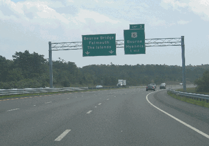
This 2008 photo shows the eastbound MA 25 Expressway approaching EXIT 3 (US 6) in Bourne. Exits were renumbered along MA 25 in 2007 to avoid duplication, with the I-195 / I-495 interchange serving as the western terminus for exit numbers. (Photo by Steve Anderson.)
THE ORIGINAL ROUTE 25, NOW PART OF I-495: In 1947, the Massachusetts Department of Public Works (MassDPW) announced plans for a "Route 25 Expressway" as part of its statewide expressway program. As originally planned, the MA 25 Expressway was to connect I-95 in Foxborough with Cape Cod. Southeast of Raynham, the expressway was to carry the MA 28 designation (this designation was dropped from the highway in 1962). The MassDPW approved preliminary route plans for MA 25 in 1957.
Between 1958 and 1967, a 15-mile-long section of the MA 25 Expressway was built by from I-195 in Wareham northwest to the Fall River Expressway / Amvets Highway (MA 24) in Raynham. This four-lane section was financed 50-50 between the state and federal governments. Upon completion of the Raynham-to-Foxborough section of I-495 in 1982 (this section's designation changed from MA 25 to I-495 in the 1970s), the state changed the designation on existing Wareham-to-Raynham section to I-495.
A CONNECTION TO THE CAPE: East of the I-195 / I-495 interchange in Wareham, the MassDPW began construction of a 2.5-mile-long, six-lane section of the MA 25 Expressway through Wareham in 1966. Originally part of the planned 260-mile-long "Cape Cod Expressway" from New York City to Cape Cod (as proposed in 1953), this section of MA 25 opened through EXIT 1 (Maple Springs Road / TO US 6 and MA 28) in 1969.
DELAYED BY A FARMER'S STEADFASTNESS: In the path of the MA 25 Expressway was Grazing Fields Farm, which was renowned for its Welsh ponies, Montdale sheep and organically grown vegetables, as well as for an artists' colony that attracted famous writers (including Mark Twain) each summer. For many years, owner Hope Ingersoll tended to the farm in relative isolation, until the MassDPW encroached on the farm in 1957 with its Route 25 proposal.
What followed was a quarter-century long fight that pitted Ingersoll against the MassDPW. The original MassDPW plan had the expressway routed straight through the 900-acre farm. However, Ingersoll had other ideas, as chronicled in a 1982 New York Times interview:
They wanted to build the road 17 feet in the air, right through the pasture and alfalfa field, right near the barn It would spoil the peace, the beauty, the whole atmosphere of the place. I don't want to impede progress. But I don't want to ruin the farm.
Spending $100,000 of her own money, she hired engineers to design an alternate route for the MA 25 Expressway that would arc to the north and east of Grazing Fields Farm. However, the MassDPW insisted that its route was more direct, less expensive and safer, and in 1978, the state reaffirmed its decision to route MA 25 through the farm.
In 1980, a judge ruled that the state had to draft a new environmental impact statement that included the "Ingersoll" alternative. Two years later, the MassDPW relented to Ingersoll, opting for her alternative that routed the expressway along the northern and eastern perimeter of the farm.
The new alternative took 90 acres of land, one-tenth the amount in the original proposal. The state offered $300,000 for the land, but in 1987 a Massachusetts Superior Court jury awarded $2.6 million for the land that the MassDPW seized by eminent domain.
Ingersoll died in 2001 at the age of 96. At the time of her death, she had donated a 150-acre buffer, which included fields, woodlands and two ponds, to the Wildlands Trust of Southeastern Massachusetts.
CONSTRUCTION FINALLY GETS UNDERWAY: Since the MA 25 Expressway went through a environmentally sensitive area, the MassDPW developed studies on how to mitigate storm water runoff. The studies were the subject of contentious public hearings throughout the 1970s and 1980s.
Engineers developed four different drainage systems - two of which used new, untested designs - to divert runoff water away from the Wareham River basin. They also incorporated a ten-inch-thick asphalt pavement that was 95 percent impervious to water, topped off by a one-inch-thick "popcorn" pavement that resisted ponding of water.
This final 6.8-mile-long section of the MA 25 Expressway, from Maple Springs Road to the Bourne Bridge approach, was completed in 1987 after two years of construction. It included the opening of a tourist information center and rest area along the eastbound lanes. Once MA 25 opened, congestion along US 6 - the old Cranberry Highway - was cut dramatically through Wareham, Onset, and Buzzards Bay, and the number of accidents fell from the 200 per year that happened prior to the completion of the expressway. However, the redirection of traffic led to the closure of many businesses that depended on tourist traffic.
ROUTE 25 TODAY: According to the Massachusetts Department of Transportation (MassDOT), the MA 25 Expressway handles approximately 40,000 vehicles per day (AADT), a figure that can approach 65,000 per day in the summer months. In recent years, the state has studied possible improvements to the interchange between MA 25, I-195 and I-495 in Wareham, but has not acted on any major construction. Exit numbers were renumbered along the MA 25 Expressway in 2007 to avoid the confusion that had resulted from different exit numbers eastbound and westbound.
This 2008 photo shows the westbound MA 25 Expressway approaching EXIT 1 (I-195) in Wareham. The MA 25 designation ends at this point as the freeway continues north as I-495. (Photo by Steve Anderson.)
FROM THE NORTH SIDE In the 1950s, the state initially planned an expressway connecting MA 25 to the Sagamore Bridge on the north side of the Cape Cod Canal. The proposed MA 25 extension was to provide a safe alternative to nearby US 6, a four-lane undivided road just north of the canal. It also was part of the ambitious "Cape Cod Expressway" proposal of a decade earlier.
Soon after this plan was revealed, questions were raised about the location of the highway. As early as 1962, the MassDPW conducted studies on the two existing vehicular crossings over the Cape Cod Canal. They found that the four-lane Sagamore Bridge (US 6) was at or above capacity, while there was excess capacity on the four-lane Bourne Bridge (MA 28).
From these studies, the state determined that the MA 25 Expressway would be extended to the Bourne Bridge instead of the Sagamore Bridge, and that expressway connections be built to MA 28 and US 6 on the south side of the canal. The state also determined that a third vehicular crossing also was needed, but not until after 1975.
TO THE "SOUTHSIDE": Between 1968 and 1977, the MassDPW developed studies for the "Southside Connector," a freeway that was to run from the southern end of the Bourne Bridge east along the south side of the Cape Cod Canal. Beginning at the Bourne Rotary on MA 28, which was to be replaced by a grade-separated interchange, the Southside Connector was to extend seven miles east through the unoccupied northern third of the Massachusetts Military Reservation (the Camp Edwards / Otis Air National Guard Base complex) before terminating at US 6 (Mid-Cape Highway) near EXIT 2 (MA 130) in Sandwich. According to the study, the connector was to be given the MA 25 designation, and it was to be built with a new parallel span next to the Bourne Bridge.
The connector was shelved soon thereafter because of concerns that it would disturb the underground aquifer that supplies water for Cape Cod. However, more recent concerns about gridlock on both sides of the canal led officials to reconsider the Southside Connector, which would cost at least $230 million if it were built today (including the cost of the Bourne Rotary replacement). Once again, many local officials want the connector to be built in conjunction with a third Cape Cod highway bridge in order to relieve congestion, but are being rebuffed by environmentalists and anti-sprawl advocates who fear that the connector and bridge would add to that congestion.
Some less expensive alternatives, such as a $15 million median barrier for Scenic Highway (US 6) or a $35 million conversion of Sandwich Road (MA 6A) into an arterial parkway, have been suggested, but they likely would not provide the congestion relief that a combined Southside Connector and Bourne Artery elimination project would offer.
The existing MA 25 Expressway (east of the I-195 / I-495 interchange in Wareham), the Bourne Bridge and the proposed "Southside Connector" should be incorporated into a newly extended I-195. The I-195 designation would continue east along US 6 (Mid-Cape Highway), providing direct Interstate service to Cape Cod.
SOURCES: "New England Road Project Backed," The New York Times (10/29/1953); "New England South Shore Highway," Interstate Study Committee (1953); "The Massachusetts Highway Story (1949-1969)," Massachusetts Department of Public Works (1969); "Proposed Route 25 and Route 28: Final Environmental Impact and Section 4(f) Statement," Federal Highway Administration and Massachusetts Department of Public Works (1977); "Farmer Wins 25-Year Fight Over Cape Road," The New York Times (10/10/1982); "Wareham Sets a New Goal" by John C. Freed, The New York Times (7/21/1985); "Maturing Parkland, Booming Development" by Leon Lindsay, The Christian Science Monitor (1/17/1986); "Bourne Woman Wins $2.6 Million in Land Battle" by Ray Richard and Kay Longcope, The Boston Globe (10/11/1989); "Cape Cod: Driving for a Safer Highway" by Jeff McLaughlin, The Boston Globe (6/27/1993); "Effectiveness of Highway Drainage Systems in Preventing Road Salt Contamination of Groundwater: Preliminary Findings" by Peter E. Church and Paul I. Friesz, Transportation Research Board (1993); "Ideas Abound for Solving Cape Gridlock" by James Kinsella, The Standard-Times (10/29/2000); "Great Conservationist Hope Ingersoll Passes Away," Wildlands News (December 2001); "Cape Cod 2000 Regional Transportation Plan: Executive Summary," Cape Cod Commission (2001); "On the Road in Bourne: Scenic Highway Median Barrier Is Top Priority" by Paul Gately, The Bourne Courier (3/21/2007); Massachusetts Department of Transportation; Alexander Svirsky.