
|
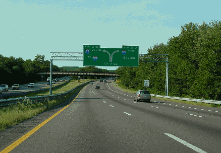
This 2003 photo shows the northbound Fall River Expressway (I-93) approaching its northern terminus at EXIT 21 (I-93 / old MA 128 / Yankee Division Highway) in Randolph. (Photo by Jim K. Georges.) |
||

|
FROM ROUTE 128 TO FALL RIVER: In 1947, the Massachusetts Department of Public Works (MassDPW) announced plans for a "Relocated Route 138" that was to handle traffic from the Boston area south to the Fall River area. The north-south highway was to be not only part of a comprehensive statewide expressway plan, but also part of an effort to revitalize the old port city of Fall River. |
||
|
Work began on the Fall River Expressway in 1950, and two years later, the first section of expressway from Assonet to Raynham opened to traffic. Little by little, the expressway, which was ceremonially renamed "Amvets Highway" not long after it opened, was extended to the north and south. By 1956, the expressway was substantially completed to Fall River; by 1958, the original 39 miles of "Relocated Route 138" was opened north to MA 128 (now I-93) in Randolph. When it was completed, the expressway received a new designation: MA 24. |
||
|
Part of the expressway plan through Fall River included the present-day MA 24 (Fall River Expressway) south of I-195, and I-195 itself east of MA 24. The final three-mile-long section of MA 24 south of I-195 was completed in 1966. |
||
|
ROADWAY LAYOUTS AND TRAFFIC COUNTS: The different sections of MA 24 are described as follows: |
||
|
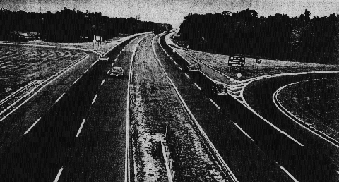
This photo from the mid-1960's shows the Fall River Expressway (MA 24) at EXIT 10 (North Main Street) in Assonet. (Photo by Massachusetts Highway Department.) |
||
|
SHOULD ROUTE 24 BECOME AN INTERSTATE? In 1997, officials from the Massachusetts Highway Department (MHD) and the Southeastern Regional Planning and Economic Development District (SRPEDD) initiated studies of necessary improvements in order to convert the Fall River Expressway into an Interstate highway. The Old Colony Planning Council adopted the proposal in 2006 as part of its 25-year transportation plan. |
||
|
The idea of an Interstate designation along MA 24 is not a new one: in the 1970's, officials in Massachusetts and Rhode Island considered the MA 24-RI 24 Expressway corridor as a possible alignment for the canceled I-895. The conversion of MA 24 to Interstate standards is estimated to cost approximately $300 million, and would have to be constructed within 12 years that such an agreement is made for the new Interstate designation. The SRPEDD gave its full support behind the Interstate conversion plan as follows: |
||
|
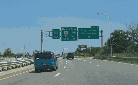
This 2006 photo shows the northbound Fall River Expressway (MA 24) at EXIT 2 (Brayton Avenue / Eastern Avenue) in Fall River. (Photo by Steve Anderson.) |
||

|
The Fall River Expressway should be widened to three lanes in each direction from EXIT 14 (I-495) in Raynham south to EXIT 12 (MA 140) in Taunton, and to eight lanes north of EXIT 14. In conjunction with this project, the existing EXIT 12 should be reconstructed as a modified-cloverleaf interchange. The southbound lane drop should lead to a two-lane exit for EXIT 12, and should incorporate a flyover ramp from southbound MA 24 to MA 140. |
||

|
Along the length of MA 24, bridges should be reconstructed, shoulders should be improved, and acceleration-deceleration lanes should be lengthened, as per the recommendations of the MHD and the SRPEDD. To facilitate these upgrades, the entire length of MA 24 - from I-93 south to the Massachusetts-Rhode Island border - should be re-designated I-695. |
||
|
The southernmost three miles of the new I-695 (MA 24) would be part of a proposed Narragansett Turnpike that would extend through southern Rhode Island. The new turnpike, which would extend south and west along the RI 24-RI 138 in Rhode Island, would have a similar route to the once-proposed I-895, which was canceled in the early 1980's. To expedite construction, tolls may be used to finance the 40-mile-long Narragansett Turnpike. The 40-mile-long turnpike would achieve the following goals: |
||

|
SOURCES: Master Highway Plan for the Boston Metropolitan Area, Massachusetts Department of Public Works (1948); "New England Road Project Backed," The New York Times (10/29/1953); "New England South Shore Highway," Interstate Study Committee (1953); "The Massachusetts Highway Story (1949-1969)," Massachusetts Department of Public Works (1969); "Southeastern Massachusetts Comprehensive Transportation Plan," Massachusetts Department of Public Works (1969); "Interstate 895: Final Environmental Impact and Section 4(f) Statement," Federal Highway Administration and Rhode Island Department of Transportation (1984); "Kings of the Road" by Ruth Trask, WPI Journal-Worcester Institute of Technology (July 1998); "State Says It Would Cost $200 Million To Make Route 24 an Interstate Highway" by Elisa Crouch, The Standard-Times (3/03/1999); "Route 24 Upgrade Is Urged" by Robert Preer, The Boston Globe (2/02/2003); "Route 24 Crash Rate Scrutinized" by Sandy Coleman, The Boston Globe (10/15/2006); Regional Transportation Plan, Southeastern Massachusetts Metropolitan Planning Organization (2007); Massachusetts Highway Department; Southeastern Regional Planning and Economic Development District; John Cairns; John Carr; Bob Malme; Dan Moraseski; Paul Schlictman; Alexander Svirsky. |
||
|
FALL RIVER EXPRESSWAY LINKS: |
||
|
FALL RIVER EXPRESSWAY CURRENT CONDITIONS: |
||

|
OFF-SITE EXIT LISTINGS: |
||
|
VIEW OR SUBMIT YOUR RATING TO RATETHEROADS.COM: |
||

|
Back to The Roads of Metro Boston home page. |
||
|
Site contents © by Eastern Roads. This is not an official site run by a government agency. Recommendations provided on this site are strictly those of the author and contributors, not of any government or corporate entity. |
||