
|
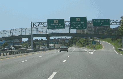
This 2006 photo shows the southbound John F. Kennedy Memorial Highway (MA 18) at the Purchase Street exit in downtown New Bedford. (Photo by Steve Anderson.) |
||

|
CONNECTING I-195 WITH THE NEW BEDFORD WATERFRONT: Planned originally as the "Downtown Connector" for the expressway section and "Waterfront Arterial" for the arterial section, the John F. Kennedy Memorial Highway traces its roots to the development of the US 6 Expressway before it became I-195 in the late 1950's. The six-lane route, which extends for slightly more than one mile south from I-195, was built with six lanes (three in each direction) to accommodate a projected 25,000 vehicles per day (AADT) by 1975. |
||
|
The expressway, which does not have any numbered exits, ends just south of US 6 (Hillman Street) at a signalized intersection with Elm Street, at which point John F. Kennedy Memorial Highway continues for 1.5 miles south to Cove Street a four-lane arterial highway with partial access control. Although there are traffic lights, this section of MA 18 has a few freeway design features. There are two southbound slip ramps (at School Street and Rivet Street) and a northbound slip ramp at Walnut Street; there also are two pedestrian overpasses at Delano Street and Rodman Street. |
||
|
In addition, the existing intersection with Coggeshall Street at the north end of the MA 18 Expressway--one of the most dangerous intersections in the state--would be improved with new signals and signs. |
||
|
AND A RE-DESIGNED INTERCHANGE WITH I-195: To address safety concerns at the I-195 / MA 18 interchange at the city's North End--specifically the traffic conflicts caused by the two loop ramps in close proximity on westbound I-195, the MHD and the Southeastern Regional Planning and Economic Development District (SRPEDD) developed plans to close the existing loop ramp from northbound MA 18 to westbound I-195. In a two-year study completed in 2002, the report cited 36 crashes within a 400-foot section of westbound I-195 between the two ramps. |
||
|
SOURCES: "The Massachusetts Highway Story (1949-1969)," Massachusetts Department of Public Works (1969); "Southeastern Massachusetts Comprehensive Transportation Plan," Massachusetts Department of Public Works (1969); "Route 18 Solution Will Be Easy" by William Corey, The Standard-Times (9/09/1998); "Mayor Appoints Panel To Steer Route 18 Fixup" by Jack Spillane, The Standard-Times (8/01/2000); "Interstate 195 Study," Southeastern Regional Planning and Economic Development District (2005); "Road to Prediction: Behind Schedule, Route 18 Development Is About To Hit Second Gear" by Rob Margetta, The Standard-Times (3/19/2006); Regional Transportation Plan, Southeastern Massachusetts Metropolitan Planning Organization (2007); Alexander Svirsky. |
||

|
JOHN F. KENNEDY MEMORIAL HIGHWAY LINKS: |
||
|
JOHN F. KENNEDY MEMORIAL HIGHWAY CURRENT CONDITIONS: |
||

|
THE EXITS OF METRO BOSTON: |
||
|
VIEW OR SUBMIT YOUR RATING TO RATETHEROADS.COM: |
||

|
Back to The Roads of Metro Boston home page. |
||
|
Site contents © by Eastern Roads. This is not an official site run by a government agency. Recommendations provided on this site are strictly those of the author and contributors, not of any government or corporate entity. |
||