
|
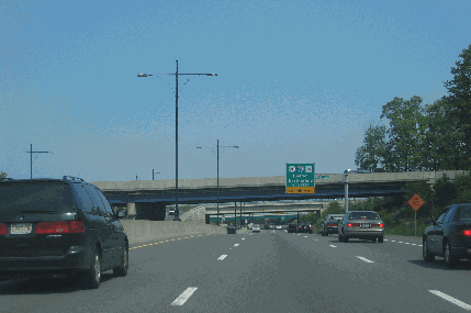
This 2005 photo shows the northbound Worcester-Providence Turnpike (MA 146) approaching the interchange for the Massachusetts Turnpike (I-90) and US 20 in Millburn. This section of MA 146 was converted to freeway during the late 1990's and early 2000's. (Photo by Steve Anderson.) |
||

|
A HIGHWAY FOR THE BLACKSTONE VALLEY: During the late 1940's, the Massachusetts Department of Public Works (MassDPW) planned an extension of Route 146 from Rhode Island north toward Worcester. The proposed route was to be an extension of RI 146 (Louisquisset Pike), which was Rhode Island's first dualized highway. |
||
|
The MassDPW built MA 146 as a four-lane divided roadway (two lanes in each direction) from US 20 in Millbury south to Boston Road in Sutton, with a narrow median separating the opposing traffic flows. From Sutton south to the Massachusetts-Rhode Island border, MA 146 was built as a three-lane undivided roadway, providing one lane in each direction and a shared lane in the center (striped for use in both directions along various sections of the roadway). Like RI 146 to the south, these sections of MA 146 provided partial control of access: although there were some grade separations, at-grade intersections and curb cuts were not uncommon. These sections were built between 1949 and 1952. |
||
|
It was not until 1981 that the MassDPW began work on rebuilding MA 146. During the next three years, the state rebuilt the 13.1-mile-long section from just south of Boston Road in Sutton to the Massachusetts-Rhode Island border, replacing the three-lane undivided section with a four-lane freeway. In contrast to the older four-lane section to the north, a wide grassy median separated opposing traffic flows. The state also established a "no-cut" line along this section of MA 146, eliminating all at-grade intersections and curb cuts. It even moved a cemetery in the path of the highway that belonged to a former almshouse in Uxbridge at the cost of $107,500. |
||
|
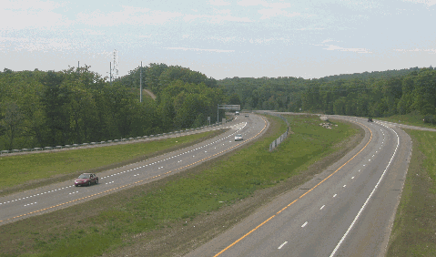
This 2005 photo shows the Worcester-Providence Turnpike (MA 146) looking south from Purgatory Road in Sutton. This section of MA 146 was upgraded in the early 1980's. (Photo by Steve Anderson.) |
||
|
MAKING THE FINAL CONNECTION TO I-290: The MHD followed up in the next half-decade with the completion of the following projects on MA 146: |
||
|
According to the Massachusetts Highway Department (MHD), the completed freeway sections of MA 146 handle approximately 25,000 vehicles per day (AADT). This figure is expected to increase significantly upon completion of the remaining freeway section to be completed between Millbury and Sutton. |
||
|
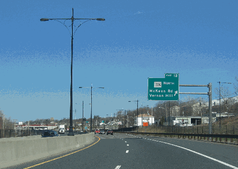
This 2008 photo shows the northbound Worcester-Providence Turnpike (MA 146) at EXIT 12 (MA 122A) in Worcester. This section of MA 146 was upgraded in the mid-to-late 2000's and features the only numbered exits on the expressway. (Photo by Steve Anderson.) |
||

|
CLOSING THE MISSING FREEWAY LINK FROM MILLBURY TO SUTTON: In October 2001, the MHD and the Central Massachusetts Regional Planning Commission initiated studies on the existing four-lane undivided section of MA 146 from the MA 122A (Main Street) interchange in Millbury south to the Central Turnpike interchange in Sutton. Built during the 1930's and 1940's, this 4.1-mile-long section of MA 146, which handles approximately 25,000 vehicles per day (AADT), suffers from substandard design. Traffic lights and curb cuts only make matters worse, though the closure of median crossovers during the early 2000's have provided a stopgap measure of safety. |
||
|
The two agencies recommended the following $16 million intermediate-term program to upgrade MA 146. Construction of these projects would not be expected to begin until at least 2010: |
||


|
EXTEND I-190 SOUTH TO PROVIDENCE: The I-190 designation should be extended to MA 146 and RI 146 from Worcester south to Providence (via I-290) upon completion of all sections to freeway-grade status. Exits should be numbered upon the completion of the MA 146 (I-190) conversion. |
||

|
SOURCES: "Central Corridor Traffic Study," Massachusetts Department of Public Works (1965); "Fast Lane for a Highway Bill," The Boston Globe (4/28/1994); "A Hard-Earned Final Rest: Uxbridge Will Bury 31 Almshouse Residents" by David Arnold, The Boston Globe (9/14/1995); "Route 146 Plans Push USX Cleanup" by John J. Monahan, The Worcester Telegram and Gazette (2/07/1996); "Bids Opened for Turnpike Connector" by Edward T. McHugh, The Worcester Telegram and Gazette (2/27/1996); "Route 146 Project Scheduled To Resume" by Emilie Astell, The Worcester Telegram and Gazette (3/02/1998); "Mass Pike Project Speeds Along" by John J. O'Connor, The Worcester Telegram and Gazette (6/27/1998); "Route 146 Upgrade Opens in Worcester" by Bill Fortier, The Worcester Telegram and Gazette (9/13/2003); "Putting Route 146 Puzzle Together" by Martin Luttrell, The Worcester Telegram and Gazette (12/21/2003); "Worcester Link to the Mass Pike: An Update on the Route 146 Connector," Worcester Regional Research Bureau (2003); "Route 146 Intersections Shape Up" by "Putting Route 146 Puzzle Together" by Martin Luttrell, The Worcester Telegram and Gazette (12/19/2004); "Route 146 Final Design Work Delayed" by Nick Kotsopoulos, The Worcester Telegram and Gazette (6/17/2005); "Route 146 Transportation Study," Massachusetts Highway Department and Central Massachusetts Regional Planning Commission (2005); Douglas Kerr; Dan Moraseski; Peter Nersesian; Alexander Svirsky; Rich Whalen. |
||
|
WORCESTER-PROVIDENCE TURNPIKE LINKS: |
||
|
WORCESTER-PROVIDENCE TURNPIKE CURRENT CONDITIONS: |
||

|
OFF-SITE EXIT LISTNGS: |
||
|
VIEW OR SUBMIT YOUR RATING TO RATETHEROADS.COM: |
||

|
Back to The Roads of Metro Boston home page. |
||
|
Site contents © by Eastern Roads. This is not an official site run by a government agency. Recommendations provided on this site are strictly those of the author and contributors, not of any government or corporate entity. |
||