 |
|
|
|
|
|
|
|
|
|
|
|
|
|
|
|
|
|
|
|
|
|
|
|
|
|
|
|
|
|
|
|
|
|
|
|
|
|
|
|
|
|
|
|
|
|
|
|
|
|
|
|
|
|
|
|
|
|
|
|
|
|
|
|
|
|
|
|
|
|
|
|
|
|
|
|
|
 |
|
|
|
|
 |
|
 |
|
|
|
|
|
|
|
|
|
|
|
|
|
|
|
|
 |
|
|
|
|
|
|
|
|
|
|
|
|
|
|
|
 |
|
|
|
|
|
|
|
|
|
|
|
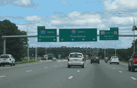
This 2010 photo shows the northbound North-South Expressway (I-95) at EXIT 11 (I-295 / Providence Beltway) in Warwick. I-95 is eight lanes wide from Warwick north to downtown Providence. (Photo by Steve Anderson.)
|
|
|
|
|
|
|
|
|
 |
|
|
|
|
 |
|
|
|
|
|
|
|
|
|
43.3 miles (69.7 kilometers)
1952-1969
|
|
|
|
|
|
|
|
|
|
|
|
|
|
 |
|
|
|
|
|
PART OF AN EARLY EXPRESSWAY SYSTEM FOR PROVIDENCE: Beginning in 1945, the Rhode Island Department of Public Works (RIDPW) devised plans for an expressway network to meet postwar traffic demands in the metropolitan Providence area. The network was comprised of two routes: a north-south route, which would later become I-95, and an east-west route, which would later become I-195. When the RIDPW released its findings in 1947, it estimated that the cost of the system would cost $52 million. The 12.2 miles of "Relocated US 1" (called "Route 5" in the plans) through Cranston, Providence and Pawtucket was scheduled to open by 1953.
|
|
|
|
|
|
|
|
|
|
|
|
|
|
|
|
|
|
|
|
|
The RIDPW provided the following description of the route through Providence:
(The) recommended route would start at the Pawtuxet River, where it would join the rural portion of an interregional route now being selected by the (RIDPW). A large part of the traffic now using the Post Road (US 1), including that from the airport, would enter Providence on the new expressway rather than on surface streets such as Elmwood Avenue.
North of the Cranston-Providence city line, the route would swing northeasterly following the Harbor Junction branch of the New York-New Haven Railroad. In so doing it would cross Elmwood Avenue, Broad Street and Eddy Street, making it possible to intercept the traffic of these principal thoroughfares and carry it to the central business district of the city.
The traffic on Allens Avenue could be tapped similarly at a point approximately one and one-half miles south of the business district, by the improvement of connecting streets. Excellent highway service would be made available to the Fields Point Port Development and Industrial District proposed by the Providence City Plan Commission.
The route would turn north before reaching Allens Avenue and parallel that street to the crosstown expressway (I-195). At that point, limited access connections would be provided for traffic turning either east or west. Ramps to the surface street system would serve vehicles with destinations in the easterly portion of the business district. Large parking lots made available by the double use of the right-of-way needed for the interchange facilities, would intercept much of this traffic before it reached the crowded downtown streets. Motorists would complete their trips by short walks or by shuttle bus.
(After the interchange with I-195), the main north-south route would turn to the north again west of Franklin Street. An interchange in this vicinity would provide for all turning movements to and from the westerly spur of the crosstown expressway (US 6 and RI 10), which ultimately will be extended from its temporary terminus at Winter Street to Hartford Avenue in the vicinity of Etna Street. Again, parking lots in the vicinity of the depressed highway would be provided to make large capacity, low-cost facilities available to a large number of long-time parkers. The north-south route would then continue northward across the Woonasquatucket River Valley, and to the west and north of the State Capitol.
The route would pass between the North Burial Ground and the right-of-way of the New York-New Haven Railroad (Amtrak), and thence into Pawtucket. It would pass to the west of the Pawtucket business district. There are more large mills and manufacturing plants west of the business district than east of it, and an expressway in their vicinity could best serve them. Otherwise, their traffic would be forced to shuttle back and forth through the business district to the expressway. The problem of accommodating traffic destined for the business district, likewise, would be relieved by dividing that traffic between an expressway on the west side of the district, and existing Pawtucket Avenue and Broadway on the east side of the area. Parking facilities and access streets on all sides could then be used with equal convenience.
The route would reach the Massachusetts state line in an area where there would be considerable latitude in meeting a route that will ultimately be selected by the Massachusetts Department of Public Works (MassDPW).
|
|
|
|
|
|
|
|
|
|
|
|
|
|
|
|
|
|
|
 |
|
 |
|
|
|
|
|
|
|
|
|
TOP: This 1963 photo shows I-95 under construction, looking north in the area of the State Capitol. (Photo by Rhode Island Department of Public Works.) RIGHT: This 1976 photo shows the interchange between the North-South Expressway (I-95) and the RI 146 Expressway, looking south toward downtown Providence. (Photo by Rhode Island Department of Transportation.)
|
|
|
|
|
|
|
|
|
|
|
|
|
 |
|
|
|
|
|
|
|
|
|
|
NEW DESIGN STANDARDS: The North-South Expressway - later known as I-95 - was to be designed in accordance with new standards set forth by the Public Roads Administration in 1945, and similar to standards being developed for expressways in neighboring Massachusetts. The design standards were established as follows:
|
|
|
|
|
|
|
|
|
|
|
|
|
|
|
|
|
Urban sections were to be constructed with three 12-foot-wide lanes (and 10-foot-wide shoulders, except through depressed sections) in each direction, with a 12-foot-wide median strip separating the two carriageways. Suburban sections were to be constructed with two 12-foot-wide lanes in each direction; additional space was to be set aside in the median for two additional traffic lanes.
|
|
|
|
|
|
|
|
|
|
|
|
Horizontal and vertical alignments were to conform to a 50 MPH design speed. This design standard called for maximum grades of three percent, maximum curves of nine percent and 800-foot sight distances.
Acceleration-deceleration lanes were to be 1200 feet long, and designed such that vehicles could enter and exit the expressway at 35 MPH.
Depending on the immediate surroundings, stone-arch bridges were to be constructed for street crossings, while concrete-and-steel bridges were to be used for viaducts and long-span bridges.
|
|
|
|
|
|
|
|
|
|
|
|
|
|
|
|
|
|
Landscaped areas were to be created within the right-of-way between the expressway mainline and the service roads.
Parking lots along the expressway were to serve as an interface between transit modes (e.g., local buses using the street network, express buses using the expressway).
|
|
|
|
|
|
|
|
|
|
|
|
|
|
 |
|
|
|
|
|
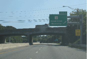
This 2008 photo shows the northbound I-95 at EXIT 1 (RI 3) in Hopkinton. The stone-arch bridge was part of the original construction from the early 1950's, and is the remaining bridge of its type along I-95. (Photo by Steve Anderson.)
|
|
|
|
|
|
|
|
|
|
|
 |
|
|
|
|
|
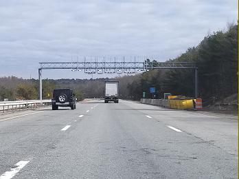
In this 2018 photo, a truck toll gantry awaits activation on northbound I-95 just north of EXIT 4 (RI 3) in Richmond. Truck tolls were implemented on I-95 in July of that year. (Photo by Steve Anderson.)
|
|
|
|
|
|
|
|
|
|
|
|
|
|
|
|
|
|
|
|
|
|
A RECONSTRUCTED ROUTE 3: While the RIDPW discussed plans for I-95 through the Providence area in the early 1950s, workers were already building the first part of I-95 through the towns of Hopkinton and Richmond. The "Relocated Route 3" (or "Nooseneck Hill") section was mapped through the southwest interior of Rhode Island, and was to eventually provide more direct access to the Providence metropolitan area than the US 1 "coastal route."
|
|
|
|
|
|
|
|
|
|
|
|
|
|
The section was constructed with two 12-foot-wide travel lanes in each direction, with a 12-foot-wide unguarded median separating the two carriageways. This section, which extended from the Connecticut-Rhode Island border north to EXIT 4 (RI 3) in Richmond, was opened to traffic on December 12, 1955.
A second section of "Relocated Route 3," from EXIT 6 (RI 3) in West Greenwich to EXIT 8 (RI 2) in West Warwick, opened to traffic in July 1958. The following year, the two sections of "Relocated Route 3" became part of I-95. The RIDPW constructed these initial sections of I-95 with a 50-50 mix of Federal and state funds.
FUNDING THE REST OF I-95: In 1955, Rhode Island voters authorized a $30 million highway bond issue that increased the state's debt load by 75 percent. With $70 million in state and Federal funds available, the RIDPW embarked on its highway building program, beginning work on I-95, I-195 and other highways. When President Dwight Eisenhower signed the bill into law creating the Interstate highway system and its 90-10 (Federal-state) funding mechanism in 1956, the RIDPW, which for nearly a decade pressed for funds to construct I-95, now developed aggressive plans to complete the highway by 1964.
Developing the plans for I-95 proved the easy part, however. The RIDPW had to obtain funds from the State Legislature, since it had to outlay funds first before it could receive the 90 percent reimbursement from the Federal government. The passage of two subsequent bond issues in 1960 and 1964 provided the RIDPW with $200 million in state and Federal funds for highway construction. More challenging for the RIDPW was the beginning of right-of-way proceedings, something that was excruciatingly difficult in urbanized Providence and Pawtucket.
|
|
|
|
|
|
|
|
|
|
|
|
|
|
|
 |
|
|
|
|
|
|
|
|
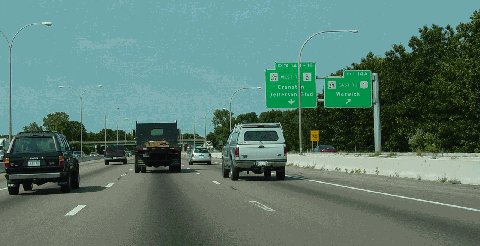
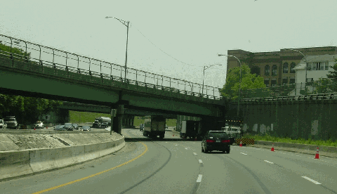
This 2003 photo shows the northbound North-South Expressway (I-95) at EXIT 14 (RI 37 Expressway) in Warwick. The interchange is served by collector-distributor (C/D) roads. (Photo by Jim K. Georges.)
|
|
|
|
|
|
|
|
|
|
|
|
|
|
|
|
|
|
|
|
|
|
|
|
|
|
|
|
|
|
BUILDING THE BRIDGES FIRST: The first urbanized section of I-95 through Rhode Island opened in 1956, when the RIDPW constructed a six-lane bridge over the Pawtucket River. Temporary approach ramps connected the usable freeway to US 1 and the surface street network in Pawtucket. On either side of the bridge, however, blocks of neighborhoods awaited the wrecker's ball.
|
|
|
|
|
|
|
|
|
|
|
|
|
|
Right-of-way acquisition through the cities of Providence, Pawtucket and Cranston began in earnest in 1958. To construct the highway, the RIDPW spent $16.5 million to purchase hundreds of homes and businesses, as well as two historic churches (First Swedish Baptist Church and St. Ansgarius Episcopal Church) along the right-of-way. However, owing to cost concerns, the gasoline storage tank near EXIT 18 (Thurbers Avenue) was not moved, resulting in the dangerous "Thurbers Avenue curve" along the I-95 mainline.
In early 1961, the RIDPW began constructing overpasses to carry local streets in Providence over the then-unbuilt I-95. Angelo Marcello, the director of the RIDPW, decided to build the highway bridges before work started on the highway itself. Marcello received criticism for having the bridges stand idle for several years, but he replied that "one of the reasons I'm doing it this way is because I know, then, that the highways will be completed.''
A MESSY SITUATION: The impending construction of I-95 did not stop the opportunistic from building in the path of the highway, selling to the RIDPW and reaping profits. City officials in Pawtucket awarded a garbage contractor the authority to build a garbage incinerator in the path of I-95. The RIDPW later had to purchase the incinerator from the city, and removed mounds of refuse from the site.
INTERCHANGE DESIGN: In an early example of community involvement, the RIDPW engaged residents and businesses in the area of EXIT 16 (RI 10 / Huntington Expressway) in Cranston. The "Friendly interchange" replaced plans for a conventional cloverleaf interchange with a new proposal for a hybrid cloverleaf-flyover interchange. It also moved I-95 closer to the New York-New Haven Railroad (Amtrak) right-of-way. During and after interchange construction, the RIDPW evaluated the impact on homes and businesses near the interchange. However, it did not study those displaced by the interchange.
The proposal for EXIT 22 (US 6 and RI 10 / Huntington Expressway) in downtown Providence was followed closely because of the relationship between the "Civic Center interchange," a proposed downtown Civic Center and the relocation of the New York-New Haven Railroad. The RIDPW - and its successor, the Rhode Island Department of Transportation (RIDOT) - studied a number of plans, from simple flyover ramps connecting to local streets, to complex multi-level interchanges connecting to a new east-west expressway through downtown. It was not until the mid-1980s that plans were cemented and work finally began on this interchange.
|
|
|
|
|
|
|
|
|
|
|
|
|
|
|
 |
|
|
|
|
|
|
|
|
This 2008 photo shows the northbound North-South Expressway (I-95) approaching the rebuilt EXIT 19 (I-195 and US 6 / East Providence Expressway) and downtown Providence. The ramp to eastbound I-195 was opened in 2007; the remainder of the interchange is opened in 2010. (Photo by Steve Anderson.)
|
|
|
|
|
|
|
|
|
|
|
|
|
|
|
|
|
|
|
|
A NEW ROUTE THROUGH PROVIDENCE AND PAWTUCKET: By the end of 1961, once the state completed its right-of-way purchases through Providence, construction began on the main roadways. Work progressed through the cities of Providence and Pawtucket as follows:
|
|
|
|
|
|
|
|
|
|
|
|
|
|
June 1963: EXIT 28 (RI 114) in Pawtucket north to Rhode Island-Massachusetts border; six lanes. To the south, this section connects to the Pawtucket River Bridge approaches completed in 1956.
September 1963: EXIT 18 (Thurbers Avenue) north to EXIT 19 (I-195 / East Providence Expressway); eight lanes. There appears to be a "stub" leading to the northbound lanes of I-95 just north of the "Thurbers Avenue curve," indicating that there may have been a spur route to a nearby waterfront industrial area.
October 1964: EXIT 19 north to EXIT 23 (RI 146 Expressway); eight lanes. The opening of this section coincided with the completion of the RI 146 Expressway.
November 1965: EXIT 23 north to EXIT 27 (US 1 and RI 15) in Pawtucket; six lanes. In order to minimize right-of-way takings, the expressway was built with tight curves, limited shoulder widths and a 45 MPH design speed. To the north, this section connects to the Pawtucket River Bridge approaches completed in 1956.
December 1965: EXIT 18 south to EXIT 16 (RI 10 / Huntington Expressway) in Cranston; six lanes.
COMPLETING I-95 SOUTH OF PROVIDENCE: By 1966, only two sections of I-95 remained to be built. As the decade progressed, the Rhode Island State Legislature found it more difficult to obtain funds for new highways. Still, officials stood by their commitment to complete I-95 through the state.
In November 1968, the RIDPW completed construction of I-95 from EXIT 8 (RI 2) in West Warwick north to EXIT 16 in Cranston. Beginning as a four-lane section in West Warwick, I-95 picks up an additional two lanes in each direction at EXIT 9 (RI 4 / Colonel Rodman Highway) in Warwick.
The final four-lane section of I-95 - from EXIT 4 (RI 3) in Richmond to EXIT 6 (RI 3) in West Greenwich - was opened to traffic on November 22, 1969. Unlike the sections built directly to the north and south, this section is characterized by a wide median. Around that time, the RIDPW reconstructed the sections built in the 1950s through Washington and Kent counties to Interstate standards by improving the pavement, adding a concrete median barrier and widening shoulders.
In 1983, the RIDOT built a new EXIT 6A (Hopkins Hill Road) in West Greenwich. The new four-ramp, partial-cloverleaf interchange was built to accommodate a nearby pharmaceutical plant, and more recently, the 400-acre "Centre of New England" development.
|
|
|
|
|
|
|
|
|
|
|
|
|
|
|
 |
|
|
|
|
|
|
|
|
This 2002 photo shows the southbound North-South Expressway (I-95) through downtown Pawtucket. The depressed section through Pawtucket is characterized by sharp curves and limited shoulder widths. (Photo by Jim K. Georges.)
|
|
|
|
|
|
|
|
|
|
|
|
|
|
|
|
|
|
|
|
COMPLETING THE CIVIC CENTER INTERCHANGE: For more than two decades, the lack of full interchange movements at EXIT 22 (US 6 and RI 10 / Huntington Expressway) caused a traffic nightmare through downtown Providence. The lack of a direct connection from the "Civic Center Interchange" to the Providence street grid exacerbated this problem.
|
|
|
|
|
|
|
|
|
|
|
|
|
|
Even before I-95 was completed through this area in 1964, engineers studied ways to solve this problem. However, they had to overcome a number of site limitations, including the existing I-95 viaduct and the Amtrak right-of-way and Woonasquatucket River below, as well as vertical constraints imposed by the desire to maintain sight lines to the nearby Rhode Island State Capitol. Since the site is also on the edge of a cove that was filled in the late 1800's, engineers also required a stable foundation on which to construct the new ramps.
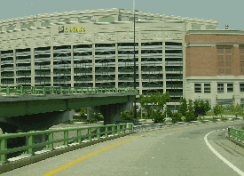
Work began on the Civic Center Interchange in 1986. The project involved the construction of nine plate-girder, multi-span continuous bridges ranging in length from 250 feet to 1,700 feet. The RIDOT completed the new bridges, which connected I-95 and the newly extended "6-10 Connector" into downtown Providence, between 1988 and 1993. In 1999, the RIDOT built additional ramps for EXIT 22C to connect to the new Providence Place mall.
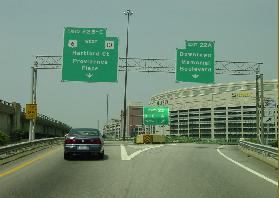
RECONSTRUCTING THE I-95 / I-195 INTERCHANGE: As part of the relocation of I-195 (East Providence Expressway) through downtown Providence, the RIDOT moved the interchange for I-195. A new high-speed, "semi-directional T" interchange was built with the relocated I-195 (Hurricane Barrier Alignment) in the area of Rhode Island Hospital, which was redesignated EXIT 19. Once the older I-195 elevated section was demolished, RIDOT built a new EXIT 20 (Point Street) on I-95 for local traffic.
The first part of the project - a connection from northbound I-95 (new EXIT 19) to eastbound I-195, including the signature arch span - opened to traffic on November 4, 2007. In addition, the RIDOT resurfaced I-95 for 1.5 miles through the area, and built new overpasses and slip ramps for local streets. The $250 million I-195 relocation project was completed in 2010, three years later than originally scheduled.
TRUCK TOLLS: In June 2018, the first two of 13 truck tolls went into operation on I-95 just north of EXIT 2 (Woodville-Alton Road) in Hope Valley and just north of EXIT 4 (RI 3) in Richmond. The two truck tolls, which are being levied on Class 8 vehicles and higher based on Federal law, are expected raise $7.2 million in revenue for RIDOT each year. The state plans to install the remaining 11 tolls on I-95, I-195, I-295, US 6, and RI 146 by the end of 2019, with the hope of raising $450 million in the next 10 years. RIDOT contracted with Kapsch TrafficCom to build the gantries for $60 million.
TRAFFIC COUNTS: According to the RIDOT, I-95 carries approximately 45,000 vehicles per day (AADT) through Washington and Kent counties, jumping to approximately 150,000 vehicles per day through Warwick and Cranston, peaking at approximately 180,000 vehicles per day through Providence, and edging down to 120,000 vehicles per day through Pawtucket.
|
|
|
|
|
|
|
|
|
|
|
|
|
|
 |
|
 |
|
|
|
|
|
|
|
|
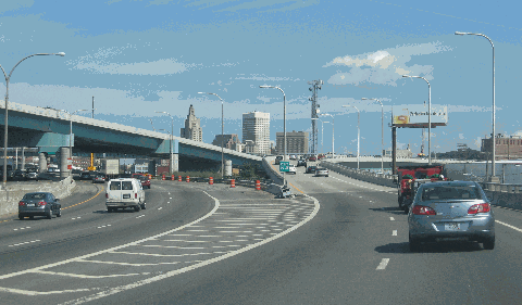
These 2002 photos show the reconstructed "Civic Center Interchange" (EXITS 22 A-B-C) in downtown Providence. (Photos by Jim K. Georges.)
|
|
|
|
|
|
|
|
|
|
|
|
|
|
 |
|
|
|
|
|
SIX LANES SOUTH OF WARWICK: To accommodate current and future traffic demands, I-95 should be widened to six lanes from EXIT 9 (RI 4 / Colonel Rodman Highway) south to the Connecticut-Rhode Island border. The work should be done in conjunction with the proposed widening of I-95 through southeastern Connecticut.
|
|
|
|
|
|
|
|
|
|
|
|
|
|
|
|
|
|
|
|
|
 |
|
|
|
 |
|
|
|
|
|
SOURCES: "Expressway System for Metropolitan Providence," Rhode Island Department of Public Works (1947); "New England Road Project Backed," The New York Times (10/29/1953); "New England South Shore Highway," Interstate Study Committee (1953); "Rhode Island Highway Opens," The New York Times (12/13/1955); "Rhode Island Roads," Rhode Island Department of Public Works (1956); "Industrial Development and Highway Planning in Rhode Island," Arthur D. Little, Inc. (1959); "A Highway Program for Rhode Island," Rhode Island Department of Public Works (1959); "I-95 Opens in Rhode Island," The New York Times (11/23/1969); "The Interstate Highway System in Rhode Island: A Force for Change in Rhode Island" by Dieter Hammerschlag, Brian K. Barber and J. Michael Everett, University of Rhode Island (1976); "Transportation 2010: Ground Transportation Plan," Rhode Island Department of Transportation (1992); "Record of Decision: Improvements to Interstate 195, Washington Bridge to Interstate 95," Federal Highway Administration and Rhode Island Department of Transportation (1997); "In the 1960's, Highways Tore Through the Cities" by Jonathan D. Rockoff, The Providence Journal (8/30/1999); "Relocation of I-195 in Providence," Rhode Island Department of Transportation (2001); "The Drive of the Future: Rerouting 195" by Bruce Landis, The Providence Journal (8/10/2004); "Accelerating on 195" by Bruce Landis, The Providence Journal (6/06/2007); "Exit from Route 95 to Route 195 Shifts from Left to Right" by W. Zachary Malinowski, The Providence Journal (12/05/2008); "To Repair Rhode Island Roads, Report Calls for New Tolls, Taxes, and Higher Fees" by Bruce Landis, The Providence Journal (12/05/2008); "R.I. To Start Collecting Tolls from Tractor-Trailers Next Week; Truckers Pledge To Sue" by Brian Amaral, The Providence Journal (6/05/2018); Maguire Group; John Cairns; Shawn DeCesari; Michael Kendricks; Dan Moraseski; Chris O'Leary; Alexander Svirsky.
I-95 shield by Ralph Herman.
Lightposts by Millerbernd Manufacturing Company.
|
|
|
|
|
|
|
|
|
|
|
|
|
|
|
|
 |
|
|
|
|
|
|
|
|
|
|
|
|
|
|
|
|
|
|
|
 |
|
|
|
|
|
|
|
|
|
 |
|
|
|
|
|
THE EXITS OF METRO BOSTON:
I-95 (Rhode Island) exit list by Steve Anderson.
|
|
|
|
|
|
|
|
|
|
|
 |
|
|
|
|
|
|
|
|
|
|
|
|
Site contents © by Eastern Roads. This is not an official site run by a government agency. Recommendations provided on this site are strictly those of the author and contributors, not of any government or corporate entity.
|
|
|
|
|
|
|
|
|
|