
|
|
||
|
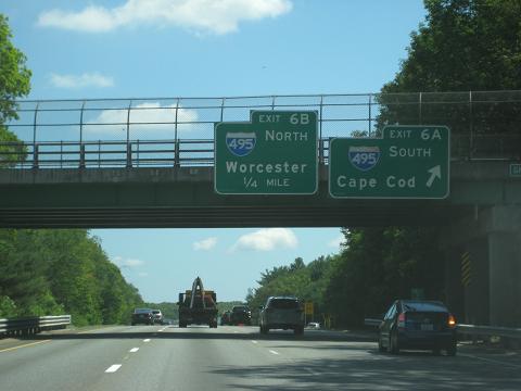
This 2015 photo shows the northbound I-95 at EXIT 6 (I-495 / Outer Circumferential Highway) at the Mansfield-Foxborough border. (Photo by Steve Anderson.) |
||
|
Length: |
||
|
26.7 miles (43.0 kilometers) |
||

|
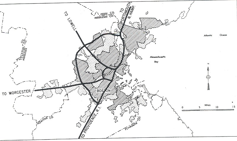
RELOCATED ROUTE 1 SOUTH OF BOSTON: In 1947, the Massachusetts Department of Public Works (MassDPW) announced plans for a "Relocated US 1" that was to provide expressway service from Boston and its southern suburbs to the Providence area. The highway was to continue north of MA 128 (Yankee Division Highway-Circumferential Highway) as the Southwest Expressway, whose route plans were divulged in a 1948 MassDPW report. The "Relocated US 1," which was also included as part of a national network devised by the Federal Bureau of Public Roads (BPR), officially became part of I-95 in 1956. |
||
|
DESIGN AND CONSTRUCTION: Unlike the original construction of I-95 north of Boston, the construction of I-95 south of Boston reflected contemporary Interstate design. The MassDPW designed the highway with three 12-foot-wide travel lanes in each direction, emergency shoulders, and bridges built with 15½-foot clearances. To improve safety and enhance aesthetics, engineers incorporated a wide, wooded median into the design of I-95. |
||
|
Further north, the MHD is in the early stages of environmental planning for the reconstruction of the I-95 (MA 128) / I-93 interchange in Canton. The proposed redesign calls for the construction of two-lane flyover ramps for northbound I-95 and southbound I-93, and reconstruction of the I-95 southbound ramp to accommodate two through traffic lanes. Additionally, as part of the MA 128 (I-95 and I-93) reconstruction project, the MHD plans to provide four through lanes in each direction for the mainline MA 128 (southbound I-95 to northbound I-93, and southbound I-93 to northbound I-95). |
||
|
COPING WITH CONGESTION: According to the Massachusetts Department of Transportation (MassDOT), I-95 carries approximately 100,000 vehicles per day (AADT) in the area of I-295 in Attleboro, approximately 80,000 vehicles per day in the area of I-495 in Mansfield, and 110,000 vehicles per day in the area of MA 128 in Canton. |
||
|
This 2015 photo shows the northbound I-95 approaching EXIT 12 (I-93 / MA 128 / Yankee Division Highway) in Canton. I-95 was to continue north of this interchange as the Southwest Expressway, but was rerouted onto MA 128 north toward Peabody in the mid-1970s. (Photo by Steve Anderson.) |
||

|
MORE CHANGES FOR INTERCHANGES: In Attleboro, EXIT 4 on I-95 should be reconstructed to provide a two-lane right exit from southbound I-95 to southbound I-295, and a two-lane left exit from northbound I-295 to northbound I-95 (possibly as a flyover ramp). |
||
|
Finally, in Canton, the existing EXIT 12 (MA 128 and I-93 / Yankee Division Highway) should be converted from a "trumpet" interchange to a high-speed, "semi-directional-T" interchange. In this major interchange reconfiguration, the predominant movements should be changed from the former route of MA 128 to the current route of I-95. The new interchange setup would accommodate three through lanes of I-95 traffic in each direction, up from one lane in each direction in the current configuration. |
||

|
SOURCES: Master Highway Plan for the Boston Metropolitan Area, Massachusetts Department of Public Works (1948); "A Report of Progress," Massachusetts Department of Public Works (1962); Recommended Highway and Transit Plan, Massachusetts Department of Public Works (1968); "The Massachusetts Highway Story (1949-1969)," Massachusetts Department of Public Works (1969); Boston Transportation Planning Review: Final Study Summary Report, Massachusetts Department of Public Works (1972); "New Canton Ramp to I-95 Is Set To Open" by Judith Forman, The Boston Globe (10/17/2002); Massachusetts Highway Department; Southeastern Regional Planning and Economic Development District; John Cairns; Dan Moraseski; Paul O'Brien; Paul Schlichtman; Alexander Svirsky. |
||

|
INTERSTATE 95--MASSACHUSETTS LINKS: |
||
|
INTERSTATE 95-MASSACHUSETTS (SOUTH OF BOSTON) CURRENT TRAFFIC CONDITIONS: |
||
|
INTERSTATE 95-MASSACHUSETTS (SOUTH OF BOSTON) VIDEO LINKS: |
||

|
THE EXITS OF METRO BOSTON: |
||

|
Back to The Roads of Metro Boston home page. |
||
|
Site contents © by Eastern Roads. This is not an official site run by a government agency. Recommendations provided on this site are strictly those of the author and contributors, not of any government or corporate entity. |
||