
|
|
||
|
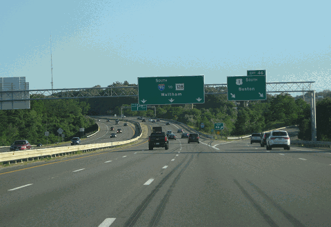
This 2016 photo shows the southbound I-95 approaching EXIT 46 (US 1) in Peabody. The gap between EXIT 45 (MA 128 / Yankee Division Highway) and EXIT 46 was completed in 1988, making it the last section of new-construction Interstate highway to be completed in Massachusetts. (Photo by Steve Anderson.) |
||
|
Length: |
||
|
26.2 miles (42.3 kilometers) |
||

|
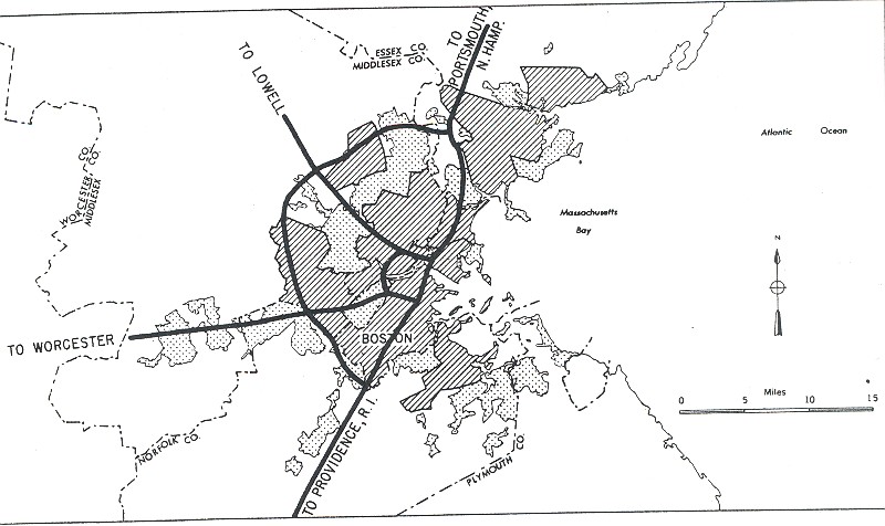
RELOCATED ROUTE 1 NORTH OF BOSTON: In 1947, the Massachusetts Department of Public Works (MassDPW) announced plans for a "Relocated US 1" that was to provide expressway service from Boston and its northern suburbs to the northern New England. The highway was to continue south of MA 128 (Yankee Division Highway-Circumferential Highway) as the Northeast Expressway, whose route plans were announced in a 1948 MassDPW report. To the north, the highway was to connect to the New Hampshire Turnpike and the Maine Turnpike, both of which were constructed (in their original four-lane configurations) in the late 1940s. |
||
|
The "Relocated US 1" replaced a three-lane section of existing US 1 along North Shore communities from Danvers to Salisbury. On the existing US 1, the middle lane was used as a passing lane, contributing to the high accident rate of existing US 1. Initially, the MassDPW planned to widen and upgrade the existing US 1 to four lanes (providing two lanes in each direction). However, after analyzing the impact along homes and businesses along the route, the MassDPW decided to construct a new dual-carriageway route that would provide three lanes in each direction. |
||
|
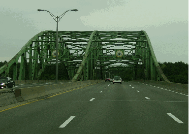
TOP: This 2002 photo shows the southbound I-95 at the old John G. Whittier Bridge over the Merrimack River. Named for a local 19th century Quaker poet who was a leader in the Abolitionist movement, the John G. Whittier Bridge was modeled on the Sagamore and Bourne bridges leading to Cape Cod. (Photo by Jim K. Georges.) |
||
|
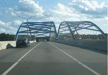
BOTTOM: This 2017 photo shows the completed northbound span of the new Whittier Bridge. Six lanes of I-95 were diverted temporarily onto the new northbound span while the new southbound span was being built. (Photo by Steve Anderson.) |
||
|
INTERSTATE UPGRADE: As early as 1962 - less than a decade after completion - officials from the MassDPW contemplated upgrades to bring the existing 21 miles of I-95 up to Interstate standards. Originally, the MassDPW expected the upgrade to cost $7.6 million. In advance of the upgrade, the MassDPW re-striped the existing roadways: it converted the existing right lanes into emergency shoulders, thereby reducing capacity from six to four lanes. |
||
|
In 1964, the MassDPW commissioned an engineering report on the Danvers-to-Salisbury section of I-95. The study, which was completed in 1966, recommended an eight-lane configuration from EXIT 45 (MA 128 / Yankee Division Highway) in Peabody north to the EXIT 57 (MA 113) in Newburyport, six lanes from EXIT 57 north to EXIT 59 (I-495 / Outer Circumferential Highway) in Salisbury, and eight lanes from EXIT 59 north to the Massachusetts-New Hampshire border. By the end of the decade, the MassDPW raised the cost estimate on the I-95 reconstruction to $30.5 million. |
||
|
Since it precedes the Interstate highway system by almost a decade, (I-95) does not conform in all cases to Interstate design standards concerning speed, access control, bridge clearances, ramp geometrics, median width, alignment and safety criteria. In addition, increased traffic on this route, especially during weekend peak travel periods, indicated a need for additional capacity and increased motorist safety. The conditions of the existing road surface are poor, and rebuilding of the pavement and sub-base would be required whether the proposed improvement is adopted or not. |
||
|
The reconstruction of the 20.8 miles of I-95 progressed as follows: |
||
|
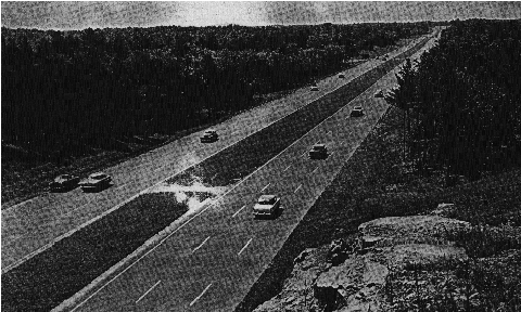
This 1962 photo shows the original six-lane I-95 -- which was built as "Relocated US 1" -- near EXIT 54 (MA 133) in Georgetown. After this photo was taken, the right lane in each direction was removed to provide a shoulder lane. This section was reconstructed as an eight-lane route in the 1970s. (Photo by Massachusetts Department of Public Works.) |
||
|
COMPLETING THE MISSING LINK: While the MassDPW reconstructed the existing I-95 from Danvers north to Newburyport, it began construction on a 4.5-mile-long section of I-95 on new alignment from EXIT 50 (US 1) in Danvers south to EXIT 46 (US 1) in Peabody. Begun in 1969, the I-95 section, which runs just parallel to US 1, was opened to traffic in 1975. |
||
|
The opening of the Danvers-to-Peabody section left one final section of I-95 unfinished: a 1.5-mile-long link from EXIT 46 (US 1) to EXIT 45 (MA 128 / Yankee Division Highway) within the town of Peabody. With the cancellation of the Northeast Expressway (I-95) through Lynn Woods in 1972, MassDPW engineers submitted new designs for the I-95 / MA 128 interchange. In 1984, the Federal Highway Administration (FHWA) approved plans for the missing link of I-95. The new design called for a six-lane section of I-95 on new alignment, and the realignment of the existing MA 128 through a new "semi-directional T" interchange. This final section was opened to traffic in 1988, thereby completing I-95 through Massachusetts. |
||
|
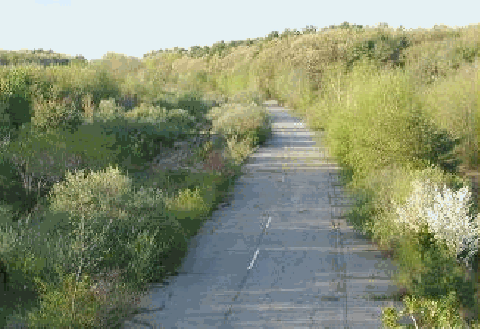
This 2001 photo shows an abandoned section of I-95 in Newburyport, about two miles south of the Whittier Bridge. Constructed as part of the "Relocated US 1" in the early 1950s, this section was abandoned when I-95 was realigned and expanded in the mid-1970s. (Photo by Alexander Svirsky.) |
||

|
SOURCES: Master Highway Plan for the Boston Metropolitan Area, Massachusetts Department of Public Works (1948); "A Report of Progress," Massachusetts Department of Public Works (1962); Recommended Highway and Transit Plan, Massachusetts Department of Public Works (1968); "The Massachusetts Highway Story (1949-1969)," Massachusetts Department of Public Works (1969); Boston Transportation Planning Review: Final Study Summary Report, Massachusetts Department of Public Works (1972); "Interstate 95, Peabody to Newburyport: Environmental Impact and Section 4(f) Statement," Federal Highway Administration and Massachusetts Department of Public Works (1973); "Access to I-95 from Route 114 Is Getting Near" by Mac Daniel, The Boston Globe (2/17/2002); "New Whittier Bridge Makes History" by Brianna Fries, American Infrastructure Magazine (November-December 2018); Chris Commans; Dan Moraseski; Paul Schlichtman; Matt Smith; Alexander Svirsky. |
||

|
INTERSTATE 95--MASSACHUSETTS LINKS: |
||
|
INTERSTATE 95-MASSACHUSETTS (NORTH OF BOSTON) CURRENT TRAFFIC CONDITIONS: |
||
|
INTERSTATE 95-MASSACHUSETTS (NORTH OF BOSTON) VIDEO LINKS: |
||

|
THE EXITS OF METRO BOSTON: |
||

|
Back to The Roads of Metro Boston home page. |
||
|
Site contents © by Eastern Roads. This is not an official site run by a government agency. Recommendations provided on this site are strictly those of the author and contributors, not of any government or corporate entity. |
||