This 2003 photo shows the southbound I-91 through downtown Springfield. Major reconstruction along this elevated section of I-91 continued through late 2005. (Photo by Jim K. Georges.)
A MODERN ALTERNATIVE TO OLD US 5: In 1944, the U.S. Bureau of Public Roads (BPR), in conjunction with the U.S. War Department, proposed a 33,920-mile network of "interregional highways" that was to provide a modern, high-speed alternative to the existing network of U.S. highways. One of these highways was the route of today's I-91 from New Haven north to the Canadian border. However, the report advocated construction of a four-lane freeway only as far north as Greenfield; and a two-lane ("super-2") highway from Greenfield north to the Canadian border.
After World War II ended, Congress took up the "interregional highway" plan and improved upon it by devising a 40,000-mile network of modern freeways, which was the precursor to the Interstate highway system. The network included a full freeway replacement for the existing US 5, but funding for the new highways was not provided. The formula for funding what eventually would become the Interstate highway system was not set into law until 1956, when President Eisenhower signed legislation calling for 90 percent Federal reimbursement of state construction expenses. The proposed I-91 was estimated to cost $98 million.
In the meantime, state highway officials drafted plans for a freeway network in the Springfield-Holyoke-Chicopee area. The 1953 master plan had early proposals for the route of US 5 (which eventually became I-91) and US 20 (which eventually became the Massachusetts Turnpike / I-90). While plans for a beltway went nowhere, the master plan included plans for I-291 (Springfield Expressway) and I-391. Only I-291 was included in the Federal-aid Interstate program.
PLANNING THE ROUTE: Northerly stretches of the proposed route were fairly easy to map out. The proposed I-91 was to use an abandoned right-of-way for the New York, New Haven and Hartford Railroad from Bernardston south to Northampton. However, planning the route was much more complicated south of Northampton.
In 1958, the American Society of Civil Engineers described the many difficulties in planning the Springfield-to-Northampton section of I-91 as follows:
The selection of (route) alignment and the extent to which it may be chosen to fit the ground economically, depends upon the geometric design standards adopted for the construction. These standards in turn depend upon the amount and type of transportation usage expected In this case, since I-91 is part of the Interstate System, the geometric standards for design are fixed by law
With the classification of service established and the appropriate standards of alignment fixed thereby, ordinarily the combination of tangents and horizontal curvature is sought that will best fit the surface of the ground. At the same time, consideration must be given to factors other than the ground fit (such as proximity to schools, churches and other buildings)
While consideration of right-of-way problems may be the principal influence modifying the best choice of alignment, there are several other factors to be taken into account as well (such as crossings of roads, railroads, streams and utilities) The purpose of preliminary surveys is to select the line and grade which satisfies the geometric design criteria at the least cost of the transportation benefit sought.
At the border of Northampton and Easthampton, I-91 originally was to cross an "oxbow" (or crescent-shaped lake that sometimes rejoins the parent) of the Connecticut River along a viaduct. MassDPW engineers designed a bridge to cross the southern end of the "oxbow," but raised the profile of I-91 above the northern end of the "oxbow." While engineers kept the southern end of the "oxbow," their plans had the highway cut through the nearby hamlet of Mount Tom Junction.
Moving south toward Springfield, state highway officials coordinated with planning officials to determine the route of I-91. Original plans called for the highway to be routed along the west bank of the Connecticut River in West Springfield, but officials in Springfield wanted to integrate the highway into the city's 1958 urban renewal plans. State highway officials concurred because a short, existing section of US 5 through West Springfield that was built during the early 1950's failed to meet Interstate design standards. The proposed I-91 was moved subsequently to the east bank of the river.
Robert Coté, frequent contributor to misc.transport.road, reflected on the early planning of I-91 through Springfield as follows:
My grandfather owned The Coté Press, one of several businesses "displaced" by the weird but ultimately self- and societal-beneficial alignment. Remember, the old road was on the west side of the Connecticut River. It was only the stupid urban renewal plans of Springfield that made the highway cross twice to bypass Agawam and West Springfield that caused the current configuration.
These kinds of issues date back centuries to the time when West Springfield was the second largest city in all of New England behind Boston. (Yes, I can defend this weird claim.) In fact, the original reason for the first two permanent crossings were because of the mandatory Westside (still called to this day) attendance at religious and public meetings in Springfield city.
State and city officials routed Springfield's I-91 segment along an active New York, New Haven and Hartford Railroad (Amtrak) right-of-way. At the time, the riverfront right-of-way was thought to be of little value, but the selection of the route only exacerbated the problem of cutting the city off from the waterfront. The highway also severed the working class, residential North End of the city, and at the city's southern end, it claimed the mansion of Everett Hosmer Barney (a skate blade magnate and philanthropist) in Forest Park.
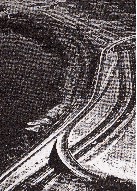
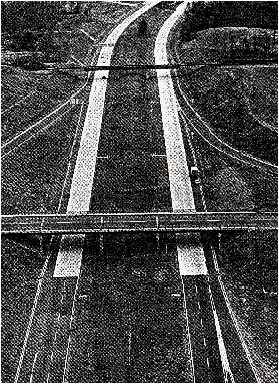
These 1962 photos show early sections of I-91 looking north at EXIT 2 (MA 83) in Springfield (left photo), and looking south at EXIT 28 (MA 10) in Bernardston (right photo). The 55-mile-long I-91 was not completed through the commonwealth until 1970. (Photos by Massachusetts Department of Public Works.)
BUILDING I-91: As the 1950's came to a close, two sections of I-91 - 6.8 miles from the Massachusetts-Vermont border south to a temporary junction with US 5 / MA 10 in just south of the Bernardston-Greenfield border (and south of EXIT 28), and 4.1 miles from the Connecticut-Massachusetts border north to EXIT 3 (US 5 / South End Bridge) in Springfield - were under construction. These initial sections were completed during the summer of 1960. (Part of the southernmost section of I-91 was built atop the existing US 5.)
Two additional sections followed in 1964: a short 1.2-mile-long segment connecting EXIT 3 to former EXIT 6 (Union Street / Springfield Center), and a 7.8-mile-long segment between EXIT 21 (US 5 / MA 10) in Northampton and EXIT 24 (US 5 / MA 10) in Whately. This was followed in 1965 by an 8.5-mile-long segment connecting the already Northampton-Whately and Greenfield-Bernardston sections, and in 1966 by the opening of a 15.1-mile-long segment between EXIT 14 (I-90 / Massachusetts Turnpike) in West Springfield and EXIT 21.
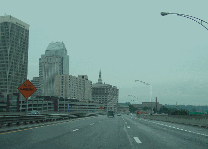
The final 6.3 miles through Springfield, Chicopee and West Springfield were the most contentious along the route. Design for this section began as early as 1962, when six alternative plans were presented before public hearings. Work on this final segment of I-91, which is comprised of a mix of viaduct (particularly in downtown Springfield) and ground-level highway, did not begin until 1966. This segment included interchanges with I-291 (which was under construction at that time) and I-391 (which had just been approved in 1965), as well as rebuilt ramps at EXIT 14 to connect with the Massachusetts Turnpike and local streets in West Springfield. Construction of I-91 left perhaps it biggest scar in downtown Springfield and the city's North End, where the highway severed the Connecticut River from the rest of the city, just as the adjacent railroad did a century earlier. When it was completed in 1970, a dozen years of building nearly 55 miles of highway finally had come to an end.
CONNECTING THE "KNOWLEDGE CORRIDOR:" I-91 is the primary link in the popularly named "knowledge corridor" of college towns between New Haven and Greenfield. It handles approximately between 65,000 and 90,000 vehicles per day (AADT) along the segment between the Connecticut-Massachusetts border and EXIT 16 (US 202) in Holyoke. This southerly section is comprised mostly of six lanes (three in each direction), except for a short four-lane segment in the area of the South End Bridge. The close proximity of the Connecticut River and adjacent Amtrak right-of-way to the immediate west, residential development to the immediate east, and the piers of the South End Bridge make widening this section to six lanes difficult.
As for the four-lane segments, I-91 handles approximately 35,000 vehicles per day through the Northampton area, about 25,000 vehicles per day from Hatfield north to Greenfield, and about 15,000 vehicles per day from Greenfield north to the Massachusetts-Vermont border.
A steel guardrail barrier separates the northbound and southbound carriageways along the southernmost stretches of I-91. Just north of EXIT 13, the two carriageways begin to separate, and a wide grassy median separates the roadways. As the highway continues north toward Vermont, the wide median becomes more forested.
The speed limit on I-91 is 55 MPH from the Connecticut-Massachusetts border north to EXIT 2 (MA 83) in Springfield, 45 MPH from EXIT 2 north to EXIT 8 (I-291 / Springfield Expressway) in downtown Springfield, 50 MPH from EXIT 8 north to the Connecticut River Bridge, and 55 MPH from the Connecticut River Bridge to EXIT 13 (US 5) in West Springfield. The remainder of I-91 is posted at 65 MPH.
CHANGES FOR INTERCHANGES: In the city of Springfield, the Massachusetts Highway Department (MHD) is finishing up long-term work on rebuilding entrance and exit ramps through Springfield. To rectify the problem of weaving caused by tightly spaced ramps, which has contributed to accidents over the years, the MHD demolished two entrance and exit ramps between EXIT 4 and EXIT 7, and is rebuilding them with different configurations. The parking structure underneath the I-91 viaduct has complicated the ramp reconstruction project. This project was completed in November 2005. Further north, the MHD completed rehabilitation and resurfacing work on the entrance and exit ramps at EXIT 10 (Main Street) in late 2004.
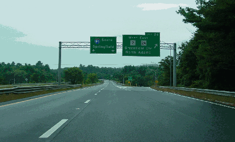
In 2004, the MHD announced plans for a fully directional interchange at EXIT 19 (MA 9 / Bridge Street) in Northampton as part of the "Connecticut River Crossing Transportation Study." This interchange currently consists of only two slip ramps (from I-91 northbound to MA 9, and from MA 9 to southbound I-91). The expanded interchange would provide three additional ramps, including a dedicated loop ramp from northbound I-91 to westbound MA 9. The $13 million project likely would not begin until at least 2015.
This 2003 photo shows the southbound I-91 at EXIT 26 (MA 2 WEST / MA 2A EAST) in Greenfield. (Photo by Jim K. Georges.)
RELIEVE THE LONGMEADOW BOTTLENECK: I-91 should be widened to three through lanes in each direction through the area of the South End Bridge. This may require rebuilding the approach piers to the South End Bridge (US 5) and realigning adjacent rights-of-way.
REBUILD EXIT 13: The tightly-spaced, modified "figure-eight" interchange at EXIT 13 (US 5) in West Springfield should be replaced by a modern single-point urban interchange (SPUI).
SIX LANES TO NORTHAMPTON: I-91 should be expanded to three lanes (from two) in each direction as far north as EXIT 19 (MA 9) in Northampton.
SOURCES: "Highway and Bridge Surveys: Preliminary Survey," Progress Report of the Committee on Highway and Bridge Surveys of the Surveying and Mapping Division, American Society of Civil Engineers-Journal of the Surveying and Mapping Division (July 1958); "The Use of Diagrams in Highway Route Location: An Experiment" by Christopher Alexander and Marvin L. Manheim, Massachusetts Institute of Technology (1961); "A Report of Progress," Massachusetts Department of Public Works (1962); "The Massachusetts Highway Story," Massachusetts Department of Public Works (1969); "US 5: A Highway to History" by Robb Strycharz, Chronos Historical Services (2001); "Forest Park Sports Public Courts for Players, and a Whole Lot More" by Ken Smith, The Boston Globe (11/07/2004); "A Plan for the North End Campus" by Diana Bernal, Erin Camarena, Beatriz de la Torre, Helen Donaldson, Christopher Hodges, Amanda Ikert and Steven Lenard, Massachusetts Institute of Technology (2004); Connecticut River Crossing Transportation Study, Massachusetts Highway Department and Federal Highway Administration (2004); John F. Carr; Robert Cote; Jay Hogan; Neil Kelly; Dan Moraseski; Scott Oglesby; Alexander Svirsky; Dan Vincent.
I-91 shield by Ralph Herman. Lightposts by Millerbernd Manufacturing Company.


