
|
|
||
|
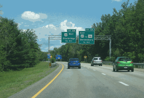
This 2017 photo shows the northbound I-395 approaching EXIT 11 (US 20, former EXIT 6) in Auburn. The conversion to mile-based exits took place in the summer of 2021. (Photo by Steve Anderson.) |
||
|
Length: |
||
|
11.9 miles (19.2 kilometers) |
||

|
FROM WORCESTER SOUTH INTO CONNECTICUT: In 1947, the Massachusetts Department of Public Works (MassDPW) proposed a north-south expressway corridor through central Massachusetts. The "Relocated Route 12," which was to connect Worcester with Connecticut to the south, was indicated as an early action proposal on the statewide expressway plan. It was to handle traffic from the existing MA 12, a two-lane road constructed in the 1930s. |
||
|
During the 1950s and early 1960s, new highways such as the Massachusetts Turnpike (I-90) and the Worcester Expressway (I-290) were constructed through the Worcester area. With congestion growing on existing two-lane roads, it soon became apparent that new radial highway capacity needed to be added. In 1965, the MassDPW Central Corridor Traffic Study reiterated the need for the "Relocated Route 12" expressway. The study proposed that the MA 12 Expressway - which was re-designated MA 52 in 1967 - serve not only as an extension of I-290, but also as part of an expanded arterial network in the Worcester area. It was estimated to cost $20 million for right-of-way acquisition and construction. |
||
|
Construction of the MA 52 Expressway began in 1965 at the intersection of I-90 (EXIT 12) and US 20 (EXIT 11) in Auburn. This early construction, which was part of the I-290 contract, was completed in 1968. One year later, MA 52 was completed through the town of Webster, from EXIT 4 (Cudworth Road) south to the Massachusetts-Connecticut state line. |
||
|
HELD UP BY ENVIRONMENTAL CONCERNS: Just south of EXIT 11 (US 20) in Auburn, the proposed route of the MA 52 Expressway was to border Eddy Pond. Since it was considered 4(f) parkland area by the Federal government, the MassDPW was required to conduct studies on potential impacts on Eddy Pond, as required by 1966 Federal law. Later, with the passage of even tougher Federal and state environmental regulations in the early 1970s - new laws became retroactively applicable to previously approved Federal highway projects - the MassDPW had to develop a new environmental impact statement on the remaining 7.4 miles of the unfinished expressway. |
||
|
The design characteristics of the MA 52 Expressway were revised as follows: |
||
|
More than a decade later, another opportunity arose to create an Interstate highway along the Route 52 corridor. In 1983, the Connecticut Department of Transportation (ConnDOT) traded in the Interstate highway mileage for the once-proposed, but never built section of I-84 (between Bolton and the Connecticut-Rhode Island border) for the CT 52 Expressway. The Federal Highway Administration (FHWA) accepted the ConnDOT Interstate trade-in, and accepted the new I-395 designation for CT 52. At the same time, the FHWA extended the I-395 designation northward into Massachusetts, along the existing MA 52 Expressway. |
||


|
However, the route almost became I-99 in 1983. The I-99 designation was considered for the Route 52 corridor in Connecticut and Massachusetts, but ConnDOT objected to the proposed designation, citing that the state-designated Route 99 went through six towns in the central part of the state and would have required extensive redesignation of an established state road. MassDPW did not raise any similar objection. |
||
|
According to the Massachusetts Department of Transportation (MassDOT), I-395 carries approximately 20,000 vehicles per day (AADT) at the Connecticut-Massachusetts border; this volume rises to approximately 40,000 vehicles per day near the I-395 / I-290 / I-90 junction in Auburn. North of EXIT 12 (I-90 / Massachusetts Turnpike) in Auburn, the four-lane I-395 becomes the six-lane I-290. |
||
|
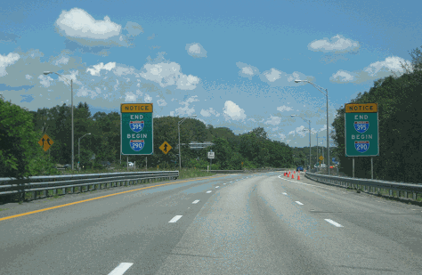
This 2017 photo shows the northern terminus of I-395 at EXIT 12 (I-90 / Massachusetts Turnpike) in Auburn. At this location, the route continues northeast as the Worcester Expressway (I-290). (Photo by Steve Anderson.) |
||

|
SOURCES: "Central Corridor Traffic Study," Massachusetts Department of Public Works (1965); "Massachusetts Route 52: Final Environmental Impact and Section 4(f) Statement," Massachusetts Department of Public Works (1975); "Massachusetts Highway Exit Numbering Complete" by Jim Kenney, The Republican (9/07/2021); Massachusetts Department of Transportation; Matt Kivela; Robert A. Malme; Dan Moraseski; Scott Oglesby; Alexander Svirsky. |
||
|
INTERSTATE 395-MASSACHUSETTS LINKS: |
||
|
INTERSTATE 395-MASSACHUSETTS CURRENT CONDITIONS: |
||
|
INTERSTATE 395-MASSACHUSETTS VIDEO LINK |
||

|
THE EXITS OF METRO BOSTON: |
||

|
Back to The Roads of Metro Boston home page. |
||
|
Site contents © by Eastern Roads. This is not an official site run by a government agency. Recommendations provided on this site are strictly those of the author and contributors, not of any government or corporate entity. |
||