

|
|
||
|
This 2016 photo shows the southbound I-295 approaching EXIT 7 (US 1A / Franklin Street) in Portland. Exit numbers were not changed along the original "Portland Loop" section of I-295 because the exits already were spaced approximately one mile apart. (Photo by Steve Anderson.) |
||
|
Length: |
||
|
53.1 miles (85.5 kilometers) |
||
|
"I don't think the present DOT could put a highway through Portland the way we did it then because of the environmental reasons" - former State Highway Commissioner David H. Stevens on the difficulties encountered building I-295 through Portland and South Portland |
||
|
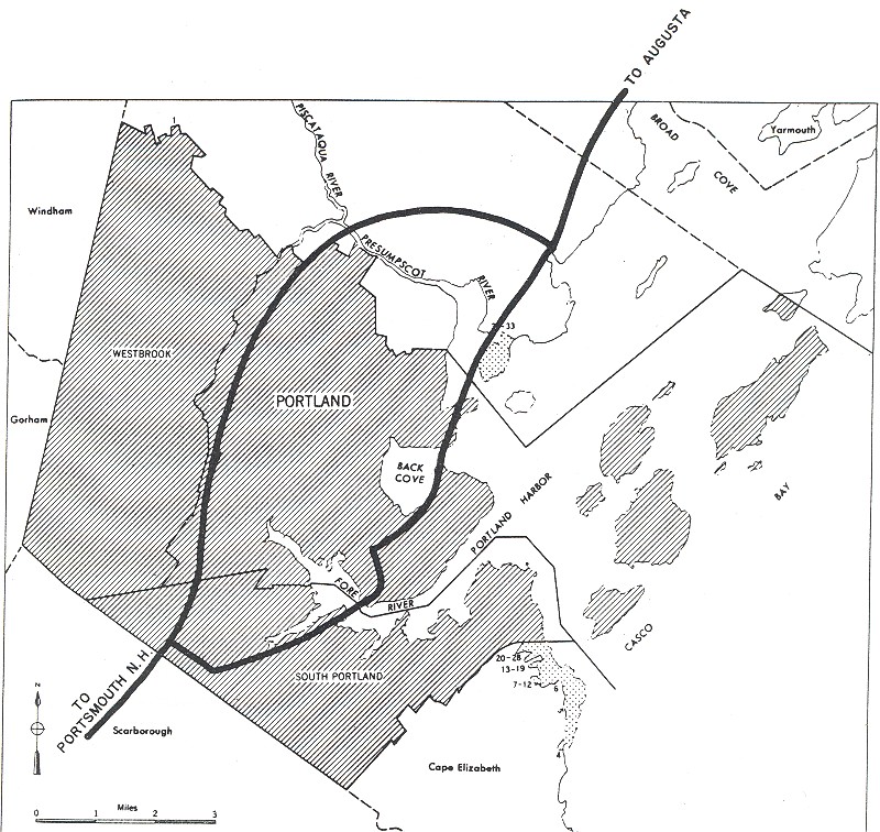
THE PORTLAND LOOP: Conceived in the early 1950s as a bypass of US 1 through downtown Portland, the 11-mile-long Portland Loop was included in preliminary plans developed by the Bureau of Public Roads (BPR) in its "Yellow Book" of proposed urban freeways. The four-lane freeway was to extend from the Maine Turnpike (I-95) at the current EXIT 45 in South Portland north to Falmouth, where a separate US 1 freeway was being planned to extend north to Brunswick. |
||
|
Even before the current I-295 became eligible for 90 percent financing on the route in 1956, Maine officials had initiated work on a one-mile-long section of the highway north of Portland's Back Cove (and north of downtown) two years earlier. At the southern end of the route, the state highway department purchased right-of-way along Long Creek in South Portland. The original plans called for I-295 to cross the Fore River from South Portland to Portland over the then-new Veterans Memorial Bridge (built in 1954) and entering Portland along the Valley Street-St. John Street corridor (US 1), but officials decided against this plan because the Veterans Memorial Bridge did not meet Interstate highway design standards. |
||
|
With the southernmost seven miles of I-295 awaiting construction, Maine highway officials entertained a proposal to push the proposed Interstate out of South Portland and extend it west along the "Westbrook Expressway" corridor. The plan, which was pushed by local officials in Westbrook and Gorham, was to be a bypass of the existing ME 25. |
||
|
CLAY CHAOS AND OTHER CONSTRUCTION WOES: As work progressed on the southern section of the Portland Loop during the second half of the 1960s, engineers discovered a vexing problem. Marine clays in the I-295 right-of-way had the potential to create instability in the roadbed through land slippage, poor foundation support, and insufficient drainage. To remedy the problem of unstable marine clays, engineers drilled more than 500 vertical drains in Portland and South Portland. These drains were filled with sand to stabilize the soil. |
||


|
LEFT: This 1958 photo shows the "Relocated US 1" through Freeport, which is now part of I-295. RIGHT: This 1959 photo shows the widening and upgrading of Tukey's Bridge in Portland to Interstate standards. (Photos from Highway News and the Maine Department of Transportation archives.) |
||


|
These photos from the late 1960s show construction crews drilling sand drains along the route of the future I-295 in Portland and South Portland. More than 500 of these drains were drilled and filled with sand to stabilize the marine clay, which if left unchecked would have damaged the I-295 roadbed prematurely. (Photos from the Maine Department of Transportation archives.) |
||

|
THE FORMER I-95 SECTION: Construction of "Relocated US 1" began in 1951 with the building of a short concrete frame bridge over a railroad right-of-way between EXIT 20 (Desert Road) and EXIT 22 (ME 125 / ME 136) in Freeport. By 1957, a new four-lane freeway from Freeport north to EXIT 28 (US 1) in Brunswick opened to traffic. Four years later, the freeway was extended south from Freeport to the Falmouth Spur and I-295 in Falmouth. |
||
|
When the new "Relocated US 1" freeway opened, it had received a new designation: I-95. The I-95 designation continued south along the Falmouth Spur toward the Maine Turnpike. However, the extension of I-95 from Brunswick north to Gardiner stayed in limbo for years, given the priority of Maine highway officials to finish I-95 further north and the existence of another route - the Maine Turnpike (which did not have a designation at the time) - for through traffic. When strict new environmental regulations went into effect in 1970, officials had to re-submit plans for the missing Brunswick-to-Gardiner I-95 link. |
||
|
THE "I-95 COASTAL ROUTE" BECOMES I-295: To reinforce the notion that I-95 was the through traffic route and reduce motorist confusion, MaineDOT submitted plans to the American Association of Highway and Transportation Officials (AASHTO) to re-designate I-95 from Falmouth to Gardiner as I-295, and reverting the I-95 designation to the Maine Turnpike. Completing the "musical chairs" of designations, the I-495 designation on the Maine Turnpike (which came into being in 1987) was applied to the short Falmouth Spur; the I-495 designation is not signed on the spur. |
||

|
After five years of discussions between state and Federal highways officials, the AASHTO approved the re-designations effective in 2004. Upon the re-designation, I-295 now stretched 52 miles from Scarborough to Gardiner. |
||

|
This 2005 photo shows the northbound I-295 approaching EXIT 1 (US 1) in Scarborough. (Photo by Alex Nitzman and Carter Buchanan.) |
||
|
IMPROVING I-295: According to MaineDOT, I-295 carries approximately 80,000 vehicles per day (AADT) through the Portland area. This volume dwindles down to about 30,000 vehicles per day along the Freeport-to-Brunswick section and about 15,000 vehicles per day along the Brunswick-to-Gardiner section. |
||
|
In 2007, MaineDOT devised a long-range proposal to widen I-295 to six lanes (from four) from EXIT 2 (Scarbourgh Connector) in South Portland north to EXIT 9 (US 1) in downtown Portland, and from EXIT 11 (I-495 / Falmouth Spur) in Falmouth north to EXIT 15 (US 1) in Yarmouth. The two new lanes would be built in the median strip, requiring the construction of a concrete ("Jersey") median barrier. The state anticipates a 20 percent increase in traffic along I-295 from Scarborough to Brunswick, but in public hearings held in early 2008 the widening proposal was panned by those who favored upgraded rail service north of Portland. |
||

|
This 2013 photo shows the northbound I-295 approaching EXIT 28 (US 1) in Brunswick. (Photo by Alex Nitzman and Carter Buchanan.) |
||

|
The state should proceed with plans to widen I-295 to six lanes (from four) from EXIT 2 (Scarbourgh Connector) in South Portland north to EXIT 9 (US 1) in downtown Portland, and from EXIT 11 (I-495 / Falmouth Spur) in Falmouth north to EXIT 15 (US 1) in Yarmouth. |
||

|
SOURCES: "South Portland Route Wins Over Westbrook Expressway," The Portland Evening Express (5/02/1964); "New Portland Interstate Route," The Portland Evening Express (2/15/1968); "Repaving Starts Along Interstate 295," The Portland Press-Herald (9/15/1994); "Change Could End Confusion Over Exits," The Portland Press-Herald (7/06/1999); "Night Work Needed for Ramp, State Says" by Justin Ellis, The Portland Press-Herald (10/23/2006); "Maine's Interstate Highway System: An Investment in Safety, Mobility, and Prosperity," Maine Department of Transportation (2006); "Crowd Criticizes I-295 Widening" by Tess Nacelewicz, The Portland Press-Herald (1/31/2008); Eric D. Bryant; Scott Oglesby; Alexander Svirsky. |
||
|
INTERSTATE 295--MAINE LINKS: |
||
|
INTERSTATE 295--MAINE CURRENT TRAFFIC CONDITIONS: |
||
|
INTERSTATE 295--MAINE VIDEO LINKS: |
||

|
THE EXITS OF METRO BOSTON: |
||

|
Back to The Roads of Metro Boston home page. |
||
|
Site contents © by Eastern Roads. This is not an official site run by a government agency. Recommendations provided on this site are strictly those of the author and contributors, not of any government or corporate entity. |
||