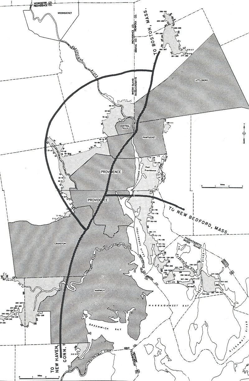
EXTENDING THE PROVIDENCE BELTWAY INTO MASSACHUSETTS: When the Rhode Island Department of Public Works (RIDPW) developed plans for its Interstate highway network, it envisioned a western loop encircling the Providence metropolitan area. Beginning in Warwick and ending in Pawtucket, the beltway was to be routed along RI 5 and RI 116, providing relief to North-South Expressway (originally planned as US 1, currently I-95) through Providence. Since original plans called for the route to be entirely built in Rhode Island, the Massachusetts Department of Public Works (MassDPW) did not develop any plans for this highway.
In the late 1950's, highway officials in Rhode Island and Massachusetts altered the route of the proposed I-295. By extending the route further north, the I-295 beltway was to provide additional traffic relief through the Pawtucket area, and for the first time, furnish expressway service for Woonsocket, Rhode Island and Attleboro, Massachusetts. The Federal Bureau of Public Roads (BPR) soon accepted the revised I-295 proposal.
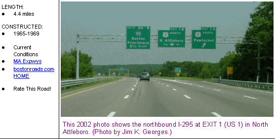
Design of the $6.5 million Massachusetts section of I-295 began in late 1961. The six-lane expressway has only two cloverleaf interchanges: EXIT 1 (US 1) in North Attleboro, and EXIT 2 (I-95) in Attleboro. (Prior to EXIT 2, northbound I-295 narrows down to two lanes, and finally to one lane.) After four years of construction, the MassDPW opened I-295 through the commonwealth in 1969. However, it was not until 1975 when the last section of the I-295 beltway opened through Rhode Island.
According to the Massachusetts Highway Department (MHD), I-295 carries approximately 40,000 vehicles per day (AADT).
EXTENDING I-295? When the MassDPW designed I-295 in the early 1960's, it provided highway stubs and ramps for a potential extension of I-295 to the east of I-95 in Attleboro. In 1966, attention shifted to providing a full beltway around the Providence metropolitan area, requiring the cooperation of Rhode Island and Massachusetts highway officials. Officials in both states sought Interstate funding for the eastern half of the beltway.
Two years later, when the Federal Highway Administration (FHWA) authorized 1,500 new Interstate miles nationwide, it added a new I-895 designation for the continuation of the Providence Beltway to the east and south of I-95. In the commonwealth of Massachusetts, the proposed I-895 was to extend through the communities of Swansea, Rehoboth and Attleboro. It was scheduled for completion by 1975. Due to intense community opposition, the MassDPW canceled the eastern half of the beltway - the section of I-895 from I-195 north to I-95 - in 1971.
However, along the route of the canceled I-895, the Massachusetts Highway Department (MHD) has long-range plans to construct an "Attleboro Connector," a divided highway spur that will connect the town to the interchange. No definitive plans have been developed by the MHD and the Southeastern Regional Planning and Economic Development District (SRPEDD) for the planned connector, which is expected to extend east to MA 152 (North Main Street), and possibly to MA 123 (Pleasant Street).
John Cairns, contributor to bostonroads.com, voiced the following thoughts on the proposed Attleboro Connector:
When the I-95 / I-295 interchange is ever reconstructed, a connector to downtown Attleboro would be a most logical component, especially since downtown Attleboro would likely benefit from the improved access (the downtown has been decimated by the opening of nearby malls). The population density through the likely routing of the connector is quite high, so it will be interesting to see the reaction of the local population when this proposal is disclosed more publicly.
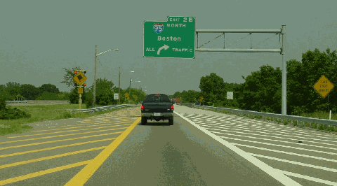
I-295 comes to an abrupt end at this half-completed cloverleaf interchange with I-95 in Attleboro. Over the years, there have been plans to extend I-295 to the east and south, and after 1968, under the I-895 designation. (Photo by Jim K. Georges.)
In Attleboro, EXIT 2 on I-295 should be reconstructed to provide a two-lane left exit from northbound I-295 to northbound I-95 (possibly as a flyover ramp), and a two-lane right exit from southbound I-95 to southbound I-295. Provisions also should be made for a future Attleboro Connector.
SOURCES: "Rhode Island Roads," Rhode Island Department of Public Works (1956); "Industrial Development and Highway Planning in Rhode Island," Arthur D. Little, Inc. (1959); "A Highway Program for Rhode Island," Rhode Island Department of Public Works (1959); "A Report of Progress," Massachusetts Department of Public Works (1962); "The Massachusetts Highway Story (1949-1969)," Massachusetts Department of Public Works (1969); Massachusetts Highway Department; Southeastern Regional Planning and Economic Development District; John Cairns; Chris O'Leary; Dan Moraseski; Paul Schlichtman; Alexander Svirsky.
I-295 shield by Ralph Herman. Lightpost by Millerbernd Manufacturing Company.


