
|
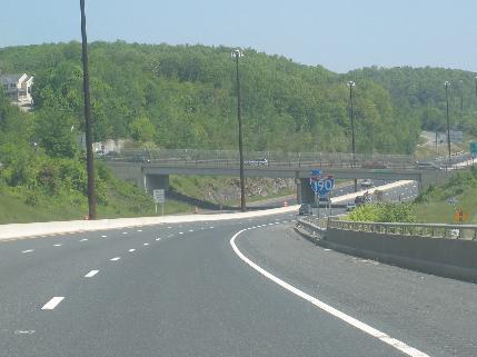
This 2005 photo shows the northbound I-190 at EXIT 2 (Ararat Street) in Worcester. (Photo by Steve Anderson.) |
||
|
FROM WORCESTER TO LEOMINSTER: As early as 1958, the Massachusetts Department of Public Works (MassDPW) began preliminary planning and engineering studies on a proposed controlled-access bypass of MA 12 from I-290 (then designated MA 122A) in downtown Worcester north to MA 2 in downtown Leominster. The MA 12 Expressway, as it was originally designated, was to be part of a much larger north-south expressway extending south to Connecticut. |
||
|
In 1965, the MassDPW incorporated the MA 12 Expressway as part of an expressway system serving central Massachusetts. Included in the "Central Corridor Traffic Study" were never-built loops around the western edge of Worcester, and around the eastern edge of Leominster. Two years later, Governor John Volpe approved the north-south freeway - now designated MA 52 - as an extended north-south route connecting Webster (on the Massachusetts-Connecticut border) with Leominster. The route was to connect to the south with the CT 52 Expressway (now designated I-395). |
||


|
During the next three years, the MassDPW held public hearings on possible locations for the Worcester-Leominster route. The original routing was to be roughly along the existing MA 12, but was changed amid concerns from residents in West Boylston and Leominster: |
||
|
In 1973, state and Federal agencies approved the final alignment and environmental impact statements. That year, the FHWA approved a new Interstate designation - Interstate 190 - for the MA 52 Expressway north of I-290 (Worcester Expressway). Some of the newly approved Federal funding came from unbuilt highway projects in the Boston area. |
||
|
POLLUTION CONCERNS HALT WORK, BRING CHANGES: In 1980, the U.S. Environmental Protection Agency (EPA) ordered the MassDPW to stop all work on I-190. The EPA cited concerns that heavy rains would send excessive amounts of dirt and other contaminants into nearby Wachusett Reservoir. State officials complied with the EPA order, but went to court to dispute the EPA findings and resume construction. In 1981, the U.S Court of Appeals in Boston ordered that work resume on I-190, ruling that the environmental impact statement filed by the FHWA was adequate. |
||
|
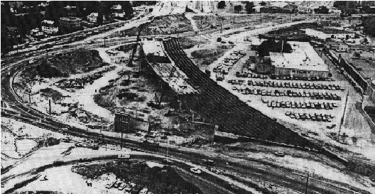
This 1979 photo shows I-190 under construction through Worcester. The highway was completed in 1983. (Photo by Massachusetts Department of Public Works.) |
||


|
NORTH TO NEW HAMPSHIRE? The 1965 "Central Corridor Traffic Study" proposed an extension of the MA 12 Expressway along the MA 13 corridor through Leominster, Lunenburg and Townsend to the Massachusetts-New Hampshire border. Extending 15 miles north of MA 2, the MA 13 Expressway was estimated to cost $14 million, and was expected to carry 15,000 vehicles per day (AADT) some 20 years hence. |
||
|
Beginning in 1970, officials from Massachusetts and New Hampshire submitted plans to the FHWA for a 63.6-mile-long Interstate highway connecting I-290 in Worcester with I-293 in Manchester. Two years later, Connecticut officials joined those from Massachusetts and New Hampshire to create a continuous Interstate highway corridor from New London, Connecticut north to Manchester, New Hampshire. |
||

|
SOURCES: Master Highway Plan for Worcester, Massachusetts Department of Public Works (1951); "Central Corridor Traffic Study," Massachusetts Department of Public Works (1965); "Report on the Status of the Federal-Aid Highway Program," Committee on Public Works, U.S. Senate (1970); "Design Hearings for Interstate 190," Massachusetts Department of Public Works (December 1974); "Pollution Threat Halts I-190 Work" by Jerry Ackerman, The Boston Globe (4/19/1980); "I-190 Gets Court Go-Ahead," The Boston Globe (2/11/1981); "In the Shadow of the Hub No More," The Boston Globe (4/10/1983); "Kings of the Road" by Ruth Trask, WPI Journal-Worcester Institute of Technology (July 1998); "Holden Weighs Losses, Gains" by Jean Laquidara Hill, The Worcester Telegram and Gazette (12/06/2006); Central Massachusetts Regional Planning Commission; Massachusetts Highway Department; Town of West Boylston; Chris Blaney; Jay Hogan; Dan Moraseski; Scott Oglesby; Paul Schlichtman; Alexander Svirsky. |
||

|
INTERSTATE 190 LINKS: |
||
|
INTERSTATE 190 VIDEO LINK: |
||
|
INTERSTATE 190 CURRENT CONDITIONS: |
||

|
THE EXITS OF METRO BOSTON: |
||
|
VIEW OR SUBMIT YOUR RATING TO RATETHEROADS.COM: |
||

|
Back to The Roads of Metro Boston home page. |
||
|
Site contents © by Eastern Roads. This is not an official site run by a government agency. Recommendations provided on this site are strictly those of the author and contributors, not of any government or corporate entity. |
||