Master Highway Plan (1948)

The following report on the proposed expressway system for the Boston area was published by William F. Callahan, commissioner of the Massachusetts Department of Public Works. It can be found at the Rotch Library, Massachusetts Institute of Technology.

SUPPLEMENTARY MATERIAL:

INTRODUCTION


For 300 years, Metropolitan Boston has been the hub of New England's transportation facilities. A seaport of renown, Boston now promises to become an air terminal of equal international importance. Railroads radiate to the north, south and west, while more than one hundred highways cross a cordon line around the metropolitan area. This accessibility promotes active trade and generates the employment to support the population of one of the world's truly great cities.

All of the people and all of the goods, whether they arrive in Boston by air, sea, rail or highway, are transported to their ultimate destinations over the streets of Boston and of the many other cities and towns comprising the metropolitan area. Superimposed on this movement is the daily travel of the residents to and from the numerous colleges and universities, the office buildings, the retail stores, the industrial plants, and all the other traffic generators of the area. It is now known for the first time that these trips by automobile, by truck, and as passengers of public carriers exceed two million people daily.

Many of the streets of Boston and in the surrounding cities and towns were intended for no more voluminous traffic than a few wagons per day and an occasional rider on horseback. These narrow streets are in no sense adequate for the movement of automotive traffic, and in some cases cannot even furnish proper access to abutting property for the delivery of goods. There are a number of fine arterial streets and parkways in the area, however, which through constant improvement have served the needs of traffic reasonably well until recent years.

As in all other large American cities, improvement of traffic facilities has been curtailed during the past two decades, first of a result of the Depression and then because of the shortages of manpower during World War II. During this same period, and despite the retarding factors mentioned, vehicular traffic in the Boston metropolitan area, as measured by gasoline consumption, has increased by 50 percent, and is currently growing at an amazing rate.

Greater Boston is no worse off or traffic facilities than other cities of comparable size. All of them are planning new urban highways that will cost many millions of dollars in each city. Boston is perhaps fortunate in not having spent large sums, as several other cities have done, for traffic improvements that are obsolete when measured against present standards for urban highways. Boston can now profit by the mistakes and experience of other cities, and can build with confidence a modern system of traffic facilities.

Your Joint Board has very wisely concluded that it is time to review past accomplishments, assemble the best available information and ideas for needed improvements, and then prepare an integrated Master Highway Plan. This plant to provide for the future needs of highway traffic must be comprehensive enough to accomplish this objective, and yet be within the financial means of the community.

In preparing such a plan, your consultants have drawn freely on the talents and past labors of the many local agencies and groups that have studied and reported on traffic and highway problems of the area. Most of the ideas contained herein were proposed first by others. A large number of reports were utilized in the preparation of these plans. Proposals for needed highways and other improvements have been taken from these reports without it being possible in all instances to give well-deserved credit. The consultants endorse, however, and assume responsibility for any opinions stated or plans proposed.

The successful culmination of an engineering, legislative and financial program to secure modern street and highway facilities for the Boston metropolitan area will require the best efforts of every individual and every agency concerned with this problem. In the accomplishment, there will be ample credit for all.

METHOD OF APPROACH


A great mass of relevant data was made available to your consultants as the basis for the conclusions and recommendations embodied in this report. The foundation of the entire Master Highway Plan rests on the facts derived from the origin and destination study of motor vehicles. These data were secured in the survey by the Massachusetts Department of Public Works with cooperation of the Public Roads Administration, Federal Works Agency. This information has been supplemented by traffic studies made by various agencies in all parts of the metropolitan area.

The consultants also had the benefit of the advice and counsel of numerous official and semi-official bodies, and that of individuals. This aid has ranged in degree from calling attention to troubling traffic spots to the submission of complete preliminary plans.

The consultants spent considerable time in the field to become familiar with the geography of the area, with the nature of the various existing traffic facilities, and with the characteristics of traffic. Reconnaissance surveys of potential rights-of-way for new highways were made on several times as many miles of routes as were finally incorporated in the recommended system of expressways. Studies were also made of the cost of alternate plans, both for rights-of-way and for construction, together with traffic-wise evaluations of such alternatives.

The 1948 Master Highway Plan for Metropolitan Area displayed this artist's conception of Boston's expressway system, looking north toward downtown Boston. The Southeast and Southwest expressways enter the city from the bottom of the map, while the Western, Northwest and Northern expressway diverge from the Inner Belt Expressway toward the top of the map. On the right side of the map, the Northeast Expressway crosses over the Mystic River on the Tobin Bridge, while the East Boston Expressway emerges from the Sumner and Callahan tunnels at Logan Airport. (Drawing by Massachusetts Department of Public Works.)

RECOMMENDED SOLUTION


A complete system of expressways to serve the entire area forms the backbone of the recommended solution to Metropolitan Boston's complex traffic problems. So that there may be no confusion in the use of terms, it should be clear that the word "expressway" as used in this report is synonymous with the terms "freeway" and "limited-access highway." Expressways in this sense are channels for the uninterrupted movement of motor vehicles. They are connected with the adjoining street system through properly designed entrances and exits at reasonable spaced intervals. Generally depressed below the level of the territory through which they pass, they occupy strips of generous width with properly landscaped side slopes, giving them a park-like appearance. They may be built as elevated structures, however, in areas of high property values, where a depressed roadway would be below sea level, or where existing underground structures such as subways make depressed roadways infeasible. In the outer portions of a metropolitan area where cross streets are infrequent, it is often possible to build expressways conforming generally with existing ground contours over considerable distances. On a true expressway of any of these types, the interferences and accident potentials of pedestrians, cross traffic, bus stops, parking maneuvers, and other traffic hazards are eliminated by physical means. Expressways may be restricted to private automobiles, or may be opened to general highway traffic. The expressways discussed herein are intended for the use of all types of vehicles unless otherwise explicitly stated.

Functional plans have been prepared for surface improvements in downtown Boston that are deemed sufficient to make possible the collection and dispersion of expressway traffic. These recommended changes will also expedite the movement of traffic to and from the area on other major arteries, present and proposed.

A network of principal streets covering the entire metropolitan area has been selected. It is recommended that the streets so designated be brought to maximum possible efficiency by the proper use of traffic signs, signals and markings; by the enactment of needed parking regulations and stringent enforcement thereof; by the installation of modern street lighting to bring the level of illumination on each artery to the standard recommended by committees of impartial authorities specializing in this field; and where appropriate, by more elaborate physical changes such as channelization, bypasses and grade separation structures.

These plans for new highway facilities and for improvements in the use of those now existing will not be adequate unless other plans now under consideration, or their equivalent, are carried out successfully. Among those complementary plans are the program for extensions and betterment of the rapid transit system, the union truck terminals proposed by the Boston City Planning Board, plans for an improved and relocated market district, and plans for off-street parking facilities not only in downtown Boston but also in other parts of the metropolitan area.

It should be emphasized that no one can ride to work on plans for highways. This report must be implemented by proper legislative action, by a sound financial plan and by a vigorous construction program to assure these recommendations being transmuted into steel and concrete.

THE EXPRESSWAY SYSTEM


The traffic analysis has shown that a number of well defined major desire lines of travel exist in the Boston Metropolitan Area. To serve the present and future traffic along these travel lines, a system of expressways has been developed to form the backbone of the highway transportation network. The data collected from the origin and destination survey have been used in the analysis of the proposed system of expressways to determine the location of the facilities that will meet the needs of the greatest number of motorists within and passing through the study areas. In selecting routes for analysis to determine the amount of traffic and the service that would be rendered, eight radial routes closely conforming to the major directional lines of travel have been chosen. Deviations from these direct lines of travel have been imposed in several instances, however, by such practical considerations as bays, hills and highly developed communities.

There are eight radial expressways included in the master plan, listed as follows:

  • East Boston Expressway (relocated MA 1A)
  • Northeast Expressway (relocated US 1 / unbuilt I-95)
  • Northern Expressway (relocated MA 28 / I-93)
  • Northwest Expressway (relocated US 3)
  • Western Expressway (relocated US 20 / I-90)
  • Southwest Expressway (relocated US 1 / unbuilt I-95)
  • Southeast Expressway (relocated MA 3 / I-93)
  • Central Artery (relocated MA 3 and US 1 / I-93)

Each of these radial routes would be connected to a central Belt Route (I-695). These expressways reflect the major desire lines of travel.

The Master Highway Plan displayed four different highway cross-sections: (1) a grade-separated section flanked by service roads, (2) elevated sections over the local street network, (3) embankments flanked by service roads, and (4) depressed sections through developed areas. (Figures by Massachusetts Department of Public Works.)

GENERAL CONSIDERATIONS


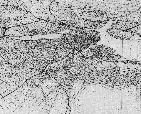
In developing the expressway system, it was necessary to make a thorough study of existing highways in order to analyze these facilities as feeders or supplemental routes, thus minimizing the number of expressways ultimately required to serve indicated traffic volumes. In this connections, the expressways have generally been located where they will not parallel or compete with existing adequate highways. The system has been so located as to provide for proper connections between the various routes and the existing and planned state and Federal highways, as the latter approach and penetrate the metropolitan area.

Four of the expressways will comprise parts of the proposed 40,000-mile network of Interstate highways to serve the entire United States. This system was originally proposed by the National Interregional Highway Committee and reported to the President of the United States in January 1944. It was approved by the several state highway departments and the Administrator of the Public Roads Administration, Federal Works Agency, on August 2, 1947. The recommended system is designed to fulfill the needs of interstate and intercity highway transportation necessary to the future economic welfare and defense of the nation. Under such a program, the Boston Metropolitan Area would be served by US 1 to the south via Providence, US 20 to the west through Springfield, US 3 through Lowell to the northwest, and by US 1 to the north through Newburyport. The present locations of these four routes must be improved, and in most cases, relocated before they will conform to Interstate standards of design for capacity, sight distances, grades, and limitation of access.

Since these highways have generally been found to be inadequate to carry heavy volumes of traffic, it is important that urban sections of the Interstate system be developed first. Therefore, Federal funds have been appropriated to aid in the construction of such urban portions of these routes. To qualify for these funds, such highways must be designed and built to high standards as limited-access highways or expressways.

In general, the expressways will require rights-of-way from 200 to 300 feet wide. Locations have been selected, therefore where such takings of real estate will not entail prohibitive cost. Long sections of sparsely developed property have been found for this purpose. Where populated areas must be traversed, the routes have generally been located in neighborhoods where real estate values are now low and where they are still declining. The new service provided by the expressways should arrest the deterioration of such neighborhoods and aid in their rehabilitation. Further studies were made of new residential and industrial developments and population trends within the areas traversed to determine the effect of these items upon the traffic potentialities and utility of each route. In laying out the system of expressways, special consideration has been given to the need for construction each route in stages over a period of years. Under such a program each unit as constructed should serve as a needed and efficient traffic artery while the balance of the system is being completed.

A further consideration in locating the master expressway system involved a study of other forms of transportation and plans for their improvement and extensions, in order to provide one integrated transportation system, rather than competing or parallel systems.

The locations of the various expressways are the result of preliminary surveys. Final studies of the individual routes required for design purposes may lead to deviations in alignments as great as several hundred feet from those proposed. It is certain, however, that alignments in the general locations indicated can be found for expressways conforming to all of the basic design standards.

DESIGN STANDARDS


Basic standards utilized in the location and design of the expressway system are in conformity with those proposed and adopted by the Federal and state governments for use on the Interstate highway system. While conformance with these standards is recommended by the interregional committee as a condition precedent to cooperation on the part of the Federal government in the construction of any route forming a link in the system, nevertheless the committee has recognized that in certain instances, topography, property values and other controlling features may prevent absolute adherence to the standards recommended. These standards, as applicable to both rural and urban expressway design, have been found to be necessary in their application because of the large volumes of high-speed mixed traffic using these highways. Many of these design features are also necessary in order to reduce the high accident rates now prevalent on most of the main arterial highways in the Boston Metropolitan Area.

As previously explained, all sections of the expressway system have been selected on the basis of the limited-access principle. Application of these basic standards and principles must be considered in classifying and designing expressways to accommodate safely the traffic volumes that they must be expected to handle over a period of at least 20 years as determined by the traffic analysis. A study of these volumes has indicated the number of traffic lanes required in the ultimate design.

Because almost the entire Boston Metropolitan Area is rapidly developing urban characteristics, it is recommended that all expressways herein be designed to urban standards. The established criterion requires that where traffic volumes are less than 20,000 vehicles daily (AADT), two lanes, each 12 feet in width, are required in each direction, separated by a suitable median divider. Where volumes are in excess of 20,000 vehicles daily, three traffic lanes in each direction are required.

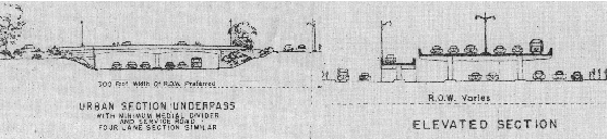
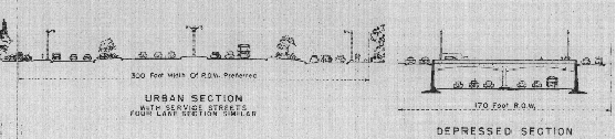
In applying the limited-access feature wherein right of access is confined to designated points or interchanges, a wide right-of-way is highly desirable. A width of 300 feet should be maintained wherever feasible in order to provide ample room for pavement, shoulders, side slopes, service roads, landscaped areas and interchange ramps. The typical cross-section contains six 12-foot-wide traffic lanes separated by a median strip of varying width. Four-lane sections are of similar design. Flanking the pavements will be two 12-foot-wide shoulders designed to accommodate heavy disabled vehicles. Surface drainage will be cared for in general by a storm water system, collecting water from curb inlets. To accommodate the heavy volume of mixed traffic, the designs incorporate pavements of adequate strength on a specially prepared 12-inch sub-base. In most sections, special consideration has been given to subsurface drainage for the entire graded section, as well as for the pavement base.

The accepted standards for horizontal and vertical curvatures and sight distances must be adhered to in order to provide a highway that will safely carry the volumes of traffic expected at a design speed of 50 MPH. The use of spiral transitions on horizontal curves is necessary.

Profiles are more or less fixed by the elevations of existing highways and railroads crossed by the expressways. However, where possible the "50-50" principle should be applied wherein the expressway grade is raised or lowered half the vertical separation distance, and the intersecting highway the remaining distance. In this manner, deep cuts and high fills are minimized on the expressways proper. A maximum three percent grade has been established as one of the governing conditions in this study. Both vertical and horizontal clearances at all railroad and highway separation structures should conform to the minimum requirements for Interstate highways. The use of collision walls at all piers and abutments is recommended. Special architectural treatment of these structures should be provided, and where exposed concrete is present, the surface should be protected with a stone facing.

In many urban districts, physical restrictions are such as to require the use of depressed sections, confined between retaining walls. On certain sections such as the Central Artery, an elevated highway design must be utilized.

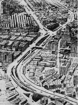
Ramp connections must be provided for egress and ingress at important intersecting highways. These ramps will connect to the expressway by means of long acceleration and deceleration transition lanes. The connection of ramps to existing streets must be channelized to provide safe turning movements at these points. At points where expressways intersect, directional interchanges will be provided, designed for normal expressway speed and capacity.

A typical "Y"-interchange would be used between three expressways. Where four expressways intersect, a directional cloverleaf or "braided" type interchange would be provided.

Because of the high speeds and large volumes of traffic on such expressways, auxiliary safety features must be furnished such as right-of-way fencing, guardrail, integral pavement markers, warning and directional signs, and roadway lighting. Large warning and directional signs must be placed well in advance of the designated points because of the high speeds attained.

On certain long sections of the expressway system, it may be desirable ultimately to install such conveniences as gasoline stations and rest rooms.

Landscaping of side slopes, median dividers and marginal strips will give the expressways a park-like appearance and absorb the hum of highway traffic. Adjacent property will be desirable for new buildings of all kinds - residential, industrial and institutional - because of the superior transportation facilities afforded and the attractive view provided. Special landscape treatment is recommended for the large areas at interchanges and access points to prevent erosion at these locations as well as for the aesthetic value.

This artist's conception from the mid-1950's shows the Central Artery as it makes its way through downtown Boston. Once regarded as a panacea for the city's traffic woes, the elevated Central Artery -- now part of I-93 -- is being replaced after a half-century of service with an underground freeway. (Figure by Massachusetts Department of Public Works.)